





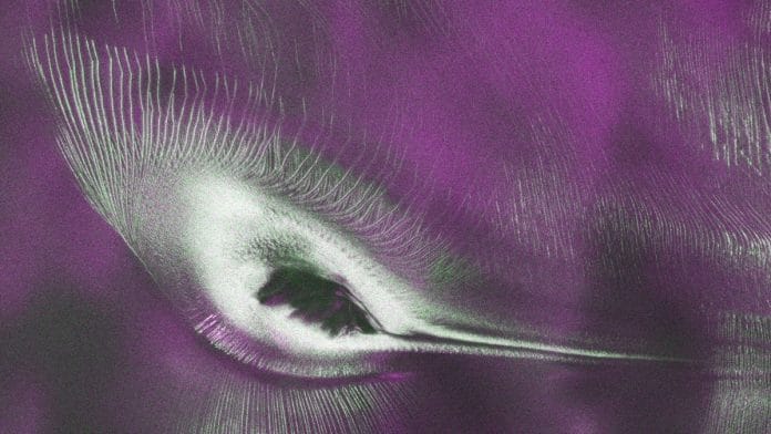


New Delhi: The NASA-ISRO synthetic Aperture Radar, or NISAR — India’s satellite partnership with the US — has captured an image of what looks like a giant hummingbird in Antarctica.
A NASA report said that this formation, nicknamed ‘the hummingbird’, was an illusion resulting from a combination of mountain, ice, and radar technology.
“An early image revealed the fractured, barren surface of an Antarctic landscape in stark detail. In a merging of science and serendipity, it also resembles something else entirely: a hummingbird,” said the report.
The images were generated by NISAR’s L-band instruments, which confirm the satellite’s capability to produce detailed imagery that is both informative and eye-catching.
The US space agency said that the colours in these images show differences in the way polarised microwave signals, which vibrate in different directions, interact with and reflect from the ice.
What the colours reveal
Over Antarctica, NISAR transmits radar waves toward Earth with a horizontal polarisation. The orientation of the signals that return — either horizontal, vertical, or both — provide clues about the object or surface that reflected them.
“Signals that come back with a horizontal polarization likely bounced off a more regular surface, such as smooth ice,” NASA said.
These signals appear as a mix of magenta, green, and white in the images.
The magenta represents signals that come back with a horizontal polarisation and were likely bounced off a more regular surface, such as smooth ice.
Similarly, signals that return with vertical polarisation may have refracted as they partially penetrated the snow and ice or scattered at different angles as they reflected off irregular surfaces, such as the faces of crevasses. Called volume scattering, these observations are displayed in green.
And then there is the white, representing areas in which magenta and green signals scatter back strongly, a possible indication that there is an equal blend of surface and volume scattering.
“The same scene viewed in optical light is almost entirely white with ice and snow. Slight shadows and rippling indicate the presence of the mountaintop, and textures in the surrounding area suggest the ice is not completely smooth,” NASA explained.
Also read:UN climate chief likens India’s clean energy growth to Tendulkar and Sooryavanshi
A precise instrument
Scientists said that while these images are remarkable to look at, they are proof of NISAR’s precision and its ability to track corners of the world that were earlier unexplored in such detail.
These images will help in observations related to glacier movements, retreat, and climate change in these regions.
NISAR is the most powerful Earth observation satellite, jointly developed by US’ NASA and India’s Indian Space Research Organisation (ISRO) — which is designed to produce high-resolution images and data on various aspects of the globe, including providing key information for predicting disasters like landslides, volcanic eruptions, floods, and earthquakes.
It is also the first satellite with dual SARs — L and S bands — operating in different frequencies. NASA’s JPL developed the L-band, while the S-band took shape in ISRO’s labs.
It was launched last year from India’s Satish Dhawan Space Centre in Sriharikota.
(Edited by Aamaan Alam Khan)