

")

The Border Roads Organisation is giving the final shape to an alternate 56-km road that will connect Sasoma in the Nubra Valley to the strategically important Daulat Beg Oldi, or DBO, Sector. The new road is via Saser La pass, which is 17,660 feet high.
The route will converge with the Darbuk-Shyok-DBO road at Murgo, reducing the distance from Leh to DBO by 79 km — from 322 km via DSDBO road to 243 km via the new road.
Strategic importance of DBO Sector
The DBO sector, also known as the Sub-Sector North (SSN), lies 60 km east of the Siachen Glacier/Nubra River and across the Saser Kangri ridge. This is the only area where physical military collusion between Pakistan and China is possible. If India were to lose control of this sector and the Saser La pass, the People’s Liberation Army (PLA) would make our defences in the Siachen Glacier untenable.
A notable feature of the DBO Sector are the Depsang Plains, which are an extension of the disputed Aksai Chin plateau, situated at a base height of 5,200 meters (17,000 feet). The Depsang Plains are interspersed with gradual hills ranging from 5,500 to 6,000 meters in height (18,000–19,500 feet). These plains are irregular in shape and measure 60-70 km from west to east and 40-50 km from north to south.
To the north, the Depsang Plains are bounded by the Karakoram Range, while the eastern boundary is defined by the Lak Tsung Range which forms the western watershed of Karakash River. To the south lies the Shahi Kangri Range. The terrain, which includes gradual hills, can be easily negotiated by wheeled and tracked vehicles, making it suitable for mechanised operations. It is also the only area that provides direct access from India to Aksai Chin.
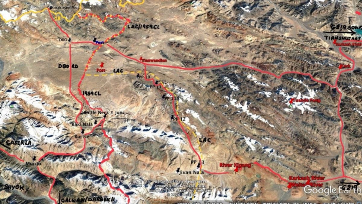
Annotated Google Earth Image of DBO/SSN Sector
The 1959 Claim Line runs north to south from the Karakoram Range via Bottleneck/Y-Junction and further south to Jivan Nala. Prior to 1962, in the northern half of the plains India’s posts were 5-10 km to the east of the 1959 Claim Line. In the southern half, our posts were 30-40 km east of Bottleneck. At the time of the 1993 ‘Agreement on the Maintenance of Peace and Tranquility along the Line of Actual Control in the India-China Border Areas’, in the northern half of the plain opposite DBO airfield, the LAC and the 1959 Claim Line coincided. In the southern half, east of the Y-Junction/Bottleneck, the LAC was at a distance of 18-20 km. However, India never physically occupied the southern half of the plains and with a base at Burtse, the Indo-Tibetan Border Police patrolled up to Patrolling Points (PPs) 10, 11, 11A, 12, and 13.
In May 2020, the PLA intruded and established a blocking position at Y-Junction/ Bottleneck to prevent patrolling up to PPs 10, 11, 11A, 12, and 13. Thus by default, it secured 600-800 square km of Depsang Plains, which India has not physically challenged so far. The DBO airfield is only 10 km from the 1959 Claim Line and the distance to our strategic road varies between 7-10 km. The entire DBO sector can be cut off by an offensive through Raki Nala, Jivan Nala and to the west from Bottleneck.
Due to the absence of road communications, until 2013, we only had a token presence in the DBO/SSN sector. Post the 2013 stand-off, we gradually built up the strength to a brigade. With effect from May 2020, India has also positioned a strong Combat Group of Mechanised Forces. Our strategy for deterrence relies on imposing prohibiting casualties in a protracted defensive battle. However, the logistics of this sector continue to pose a challenge due to vulnerability of the road communications.
Also read: Army is the only thing standing between Manipur and chaos. Time for govt to review approach
Road connectivity to DBO Sector
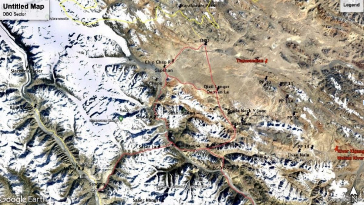
Annotated Google Earth Image showing roads to DBO Sector
In 1962, we had one battalion with two additional companies defending the DBO/SSN sector. This force was maintained by air, using the DBO airstrip and by porters/ponies/Yaks via Saser La – Murgo. The airstrip went into disuse after 1962 and the troops stationed there were maintained by airdrops. The airfield was reactivated in 2008 and thereafter has been upgraded to be used by C-130J Super Hercules aircraft. However, the airstrip can only be used for pre-hostilities buildup as it is within artillery range and would be rendered unusable in war.
Keeping in view our vulnerability, we began constructing two roads to SSN sector in 2007. The first was from Sasoma in Nubra River valley via Saser La pass – Murgo to DBO. The progress was slow and by 2020, only an un-metalled track was available for use in summer. This road is now nearing completion as reported by The Tribune. It has now been metalled and the Saser La potion will be paved with concrete interlocking tiles that can withstand damage by snow. But since Saser La gets heavy snowfall in winter, the road can only be used in summer and early/late winter, unless we build a tunnel under Saser La pass. A detailed project report for construction of the 4-km tunnel is under preparation.
The second road, which is 255 km long, was built along the Shyok River valley from Darbuk via Murgo and Burtse and it was completed in 2017. While this is considered an engineering marvel due to its passage through the gorges of Shyok River, it runs parallel to the LAC up to Murgo. The junction of Shyok and Galwan rivers is only 5 km from the LAC. The road can also be cut off at Murgo via Jivan Nala and at Burtse via Raki Nala. Furthermore, even as you move north, the road is only 7-10 km from the LAC/1959 Claim Line.
In order to partially offset this vulnerability, another road has been constructed to the west from Qizil Langer, located north of Burtse. It leads towards Gapshan and then turns east to DBO. Additionally, a number of lateral roads have been built for deployment of troops west of DBO.
Unfortunately, the new road via Saser La only partially reduces the vulnerability as it turns southeast from Saser Brangsa to converge with the DSDBO road at Murgo. Thus, the vulnerability of being cut off by the People’s Liberation Army via Jivan Nala at Murgo and via Raki Nala at Burtsa will remain.
The only solution is to urgently create a tunnel under the Saser La pass and build a new alignment from Saser Brangsa to the northeast along the Shyok and Chip Chap rivers via Chapo and Gapshan. A 4-km tunnel has been approved and work is likely to begin in the near future. Not much progress has been made on the new road due to the construction challenges. A rough alignment can be identified from satellite imagery about 15 km south of Gapshan along Chip Chap/ Shyok Rivers, and another 15 km north along Shyok River from Saser Brangsa. The remaining 25-30 km stretch between these points has a number of glaciers to the west of Shyok River and the alignment perforce has to be to its east cutting through steep slopes. This terrain is most treacherous but human endeavour can always find a way. Gapshan is already connected by a 20 km road to DBO.
Development of multiple road axes to the DBO Sector will not only strengthen its defences, but also provide the armed forces a launch pad for offensives into the Aksai Chin. The new road from Saser Brangsa to DBO via Chapo-Gapshan will be the shortest and most secure. It does present an engineering challenge but I have no doubts that the BRO will rise to the occasion.
Lt Gen H S Panag PVSM, AVSM (R) served in the Indian Army for 40 years. He was GOC in C Northern Command and Central Command. Post retirement, he was Member of Armed Forces Tribunal. Views are personal.
(Edited by Ratan Priya)