


With the Harappan Civilisation trending on social media throughout the last week of May, a familiar set of arguments resurfaced. What began as a conversation about a seal excavated at Mohenjo-Daro soon developed into a wider debate about who gets to define India’s archaeological past and what constitutes legitimate archaeological interpretation. The arguments ranged from iconography to nomenclature. However, when the discussion turned to the spatial distribution of the Harappan sites, it often stopped at the size of the settlements. The debate quickly became an Indus versus Saraswati contest, with one side arguing that all major urban centres were located along the Indus and the other pointing to sites such as Rakhigarhi as a counter.
Yet, these debates missed a more fundamental archaeological question: what makes a settlement a city? And how do cities evolve with time? The significance of Harappan urbanism cannot be reduced to identifying the largest sites or claiming the earliest settlements. Archaeological evidence points to a complex network of settlements: some were big, while a majority were small rural settlements that developed over centuries. These settlements were linked through trade, resources, traditions, and shared inheritance.
However, the overall evolution of Harappan traditions as reflected in urban centres such as Rakhigarhi, Harappa, and Mohenjo-Daro, was often presented through oversimplification, a result of selective readings of archaeological evidence. It is not easy to interpret archaeological data, especially as the context is either lost or misunderstood. But the interpretation is neither black nor white but exists in shades of grey, constantly refined through new discoveries and fresh analysis
The challenge, therefore, is not to decide whether the Indus or the Saraswati hosted the largest cities, but to understand the processes that gave rise to one of the world’s largest civilisations. Before we debate in which river valley the largest cities were located, it is necessary to ask what archaeologists mean by a city in the first place. It is equally important to ask whether the modern location of these cities should matter, as the political boundaries that divide the Harappan landscape are recent.
| Wikimedia Commons
What is a city?
According to Walter A Fairservis, a city is the result of the centralisation of a variety of interdependent activities under an effective administration. The nature of the administration may vary, but certain commonalities prevail within the larger space. Such centres do not emerge in isolation. They develop from existing social and economic structures, and in turn, influence the surrounding landscape.
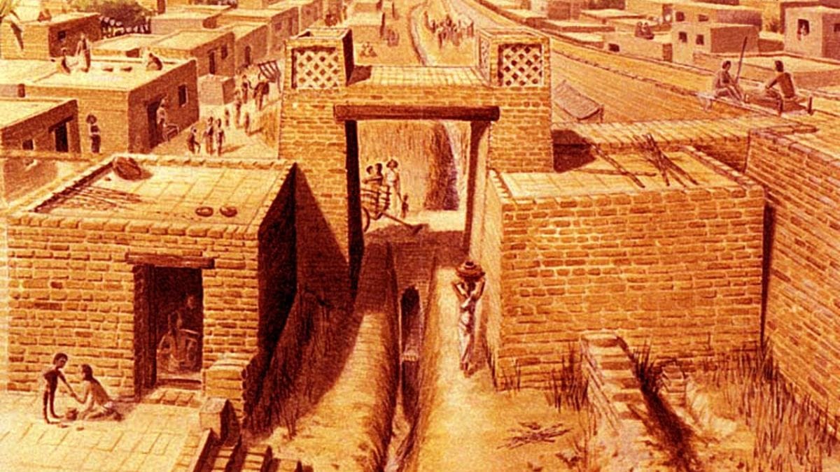
This definition is particularly useful when examining the Harappan Civilisation. Harappan cities did not appear suddenly, nor were they isolated. Rather, they emerged from earlier regional traditions and increasingly complex networks of production, exchange, and social organisation. Urban centres such as Rakhigarhi, Dholavira, Harappa, and Mohenjo-Daro display features commonly associated with urbanism, including standardisation in brick size and weights and measures, organised craft activities, a traders’ guild, technological development, and a well-maintained drainage system.
These features were the culmination of centuries of cultural development. As archaeologist Jonathan Mark Kenoyer has argued, Harappan urbanism grew out of early indigenous traditions while simultaneously interacting with neighbouring cultures. The Harappan region was surrounded by diverse communities across what are today India and Pakistan, and its urban centres developed through a long process of adaptation, innovation, and exchange. The rise of cities along the Indus and Saraswati systems was not the product of a single river, region, or group of people, but of broader social, economic, and cultural processes operating across an interconnected landscape.
Accordingly, where the early food-producing settlements had regional traits (before c. 3300 BCE), certain common features started to make way into the material culture by the mid-fourth millennium BCE. This is termed the Early Harappan phase, which lays the foundation for urbanism by the third millennium BCE. Around 2800-2600 BCE, common features and standardisation became more prominent. According to Fairservis, universally found bull figurines, human figurines, and painted motifs on pottery further emphasise a mutual tradition. Seals which possessed geometric patterns during the Early Harappan period now had Harappan letters and animal and human anthropomorphic figures engraved on them. Burial practices became another hallmark of Harappan tradition. While the settlement pattern remained largely regional and in tune with the ecology, it had bricks made in standardised size in a different ratio than those of Early Harappan bricks.
So, what many refer to as Harappan culture or civilisation is linked to only the urban phase. The Harappan traditions being hotly debated today often only refer to 800 years of urbanism.
Also read: This Harappan city holds the solution to India’s water crisis
No city evolves alone
Consider Delhi, a city of many cities. From fortified walls and gated cities of the past, the Indian capital has expanded exponentially in the last eight decades. Following Independence and the migration of lakhs during Partition, the city’s limits gradually absorbed older settlements and villages. Economic growth, industrialisation, and the rise of the service sector further extended urban development into neighbouring regions of Haryana and Uttar Pradesh, giving rise to the National Capital Region (NCR). During this transformation, places such as Gurugram, Noida, and Greater Noida evolved from largely agrarian settlements into major urban centres.
Ancient cities evolved in a similar fashion. Over 5,000 years ago, settlements such as Mohenjo-Daro, Harappa, Rakhigarhi, Ganweriwala, and Dholavira did not emerge in isolation. They developed with wider networks of villages, smaller towns, trade routes, and natural resources. With migration, cities expanded. Thousands of people flocked to them, which led to an architectural revolution, the development of a better drainage system, hierarchical division of settlements, water management systems, storage facilities such as granaries, ports, and, most importantly, markets.
However, not every settlement became a city. Many continued to function as villages, industrial centres, agricultural communities, craft-producing centres, and trading outposts. Together, these settlements created an ecosystem where each played a distinct role within the broader Harappan landscape.
But why did only a few settlements evolve into cities? The answer lies in geography. The map of the Harappan civilisation shows that the five major cities—Rakhigarhi, Dholavira, Harappa, Mohenjo-Daro, and Ganweriwala—are located in different corners of the civilisation, representing its boundary. Harappa in Punjab likely acted as an important juncture for settlements in the north, especially when trading raw materials. Mohenjo-Daro in Sindh, closer to Rohri on the Indus, was at the south-western juncture of the realm. Dholavira, on the other hand, was strategically placed, connecting the Kutch and Gujarat to Mohenjo-Daro and beyond.
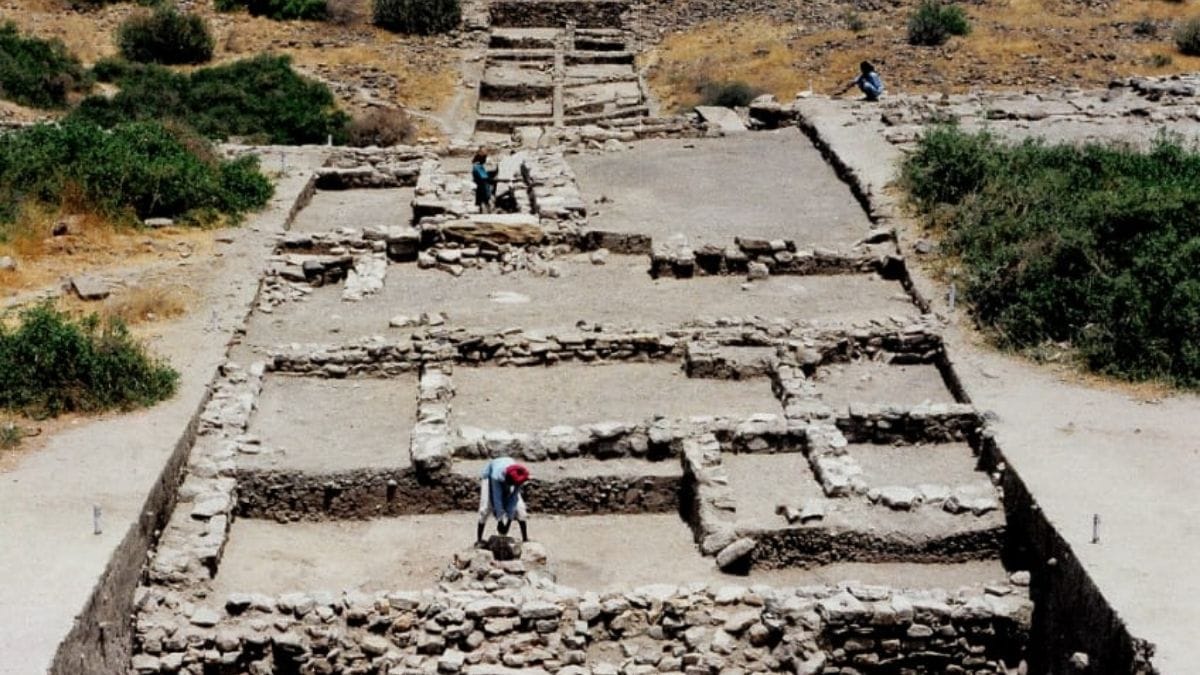
While excavating Rakhigarhi between 2021 and 2024, the team headed by Sanjay Manjul of the Archaeological Survey of India probed the reason behind the settlement’s evolution into an important urban centre at the easternmost zone of the civilisation’s expanse. Looking at the site, it was clear that even during the pre-urban phase, Rakhigarhi was a large settlement, probably the biggest in the Early Harappan phase.
During the urban phase, the city’s layout changed and became more structured and concentrated. While the excavations are still on, each year yields a new facet and new information about the people of Rakhigarhi.
Since the Harappans never lived in isolation, these city centres perhaps emerged out of necessity. Perhaps Rakhigarhi was an important link between the settlements on the Ganga, Yamuna, Doab, and beyond. Perhaps it was connecting the easternmost fringe of the civilisation to its westernmost settlements, similar to what Mohenjo-Daro did. While the latter was excavated for multiple seasons, Rakhigarhi, due to its sheer size, may take many more years to uncover. According to archaeologist Vasant Shinde’s estimates, the site spans over 500 hectares.
From an archaeological perspective, the more important question is not where the largest city was located, but how and why urban centres emerged across such a vast region. Archaeologically, a city is not defined solely on the basis of its physical size, but by the role it plays within a wider network. Its administrative functions, craft production, planning, and relationship with surrounding settlements are equally important in understanding urbanism. We must remember that cities are products of processes and not postal addresses.
Also read: The forgotten legacy of ASI’s Institute of Archaeology
On the flip side
It’s pointless to debate the size of settlements to divide what the border couldn’t. The ancient civilisation is not to be claimed based on modern national and state boundaries. But it is important to take ownership. Those who argued for Rakhigarhi must help archaeologists to protect the site. Many on social media may not even realise that RGR 6 (one of the mounds) has been completely destroyed, dug over 3 feet. Every day, a site is levelled to make way for a new apartment building. Soon, there may not be any trace of the past that we boast about online.
On the other hand, those who argue that the largest cities are only on the Indus should be ignored.
Disha Ahluwalia is an archaeologist and junior research fellow at the Indian Council Of Historical Research. She tweets @ahluwaliadisha. Views are personal.
(Edited by Prasanna Bachchhav)