





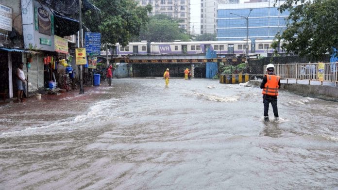


Mumbai: When heavy monsoon rains battered Mumbai continuously for a week last month, it didn’t take long for the cracks to show. Roads were inundated; train tracks were waterlogged; Traffic slowed to a crawl; and trees fell across the city, claiming three lives.
As the monsoon brought the city to its knees, the Maharashtra government declared a holiday for schools and colleges. Commuters struggled to get to work as trains were delayed because of the waterlogged tracks.
Monsoon flooding isn’t new to Mumbai. India’s financial capital gets inundated at least three or four times each year during the monsoon.
This is just one of many challenges Mumbai’s residents grapple with. Behind its glittering skyline, Mumbai has been plagued by a host of civic problems, from waterlogging and air pollution to overcrowded trains, housing issues and perpetual construction.
Experts ThePrint spoke to say the city’s ageing infrastructure and poor planning are responsible for its woes. They add that while multiple government agencies operate in the city, the biggest problem is poor implementation of development plans.
“Over the last 50 years, what has happened is that only 18-20 percent of the development plan is being implemented,” said urban planning expert Pankaj Joshi. “So the city has been growing without the implementation of a proper plan. A lot of issues like open spaces are not being addressed,” added Joshi, principal director of the Urban Centre, Mumbai.
Of these agencies, the Brihanmumbai Municipal Corporation (BMC), the country’s richest civic body with an annual budget of Rs 80,952 crore for FY 2026–27, is primarily responsible for the city’s maintenance. Other agencies, too, play a role in planning.
Infrastructure projects involve the Mumbai Metropolitan Region Development Authority (MMRDA), Maharashtra State Road Development Corporation (MSRDC), while Maharashtra Housing and Area Development Authority (MHADA) and Slum Rehabilitation Authority (SRA) oversee housing needs. At the same time, the Railways and Bombay Port Trust (BPT) also own land in parts of the city.
Over the years, BMC has worked on multiple flood mitigation projects. This includes Mithi river cleaning, pumping stations and holding tanks at low lying areas like King’s Circle, Hindamata. Currently, BMC is also working on the BRIMSTOWAD project (Brihanmumbai Stormwater Drain Project) to increase the stormwater drain capacity to drain out 50 mm rain per hour instead of the current 25 mm. MMRDA, meanwhile, is in the process of improving the urban rapid transit network by laying around 450 km of Metro network in the MMRDA region. Besides, projects aimed at easing connectivity in the city like Coastal Road, Worli-Sewri connector, Atal Setu are in various stages of completion.
“They are all engaged in a blame game and not doing anything particularly. But essentially, the main body is the BMC, which is the democratically elected body of representatives. This system of multiple agencies is not working at all,” Joshi told ThePrint.
For decades, Mumbai infrastructure grew at a pace that did not match its growing population. Over the last decade, the island city has seen rapid infrastructural construction, with bridges, expressways, sea bridges, Metro lines and redevelopment of old buildings changing the city’s skyline. But that has brought its own share of problems. With concrete, debris and barricades all over, the city has looked like a construction site for a decade now.
Also Read: Mumbai is running out of drinking water. A desalination plant in Manori is BMC’s solution
From islands to city
Geographically, Mumbai is a narrow wedge-shaped city running north to south, surrounded by the Arabian Sea on one side and the Western Ghats on the other. At one time, it consisted of seven islands that the British later reclaimed to create the island city about 200 years ago. The suburbs began to flourish in the 20th century, but its expansion largely continued along the north-south axis. East-west connectivity and expansion were limited.
The Great Fire of Bombay in 1803, which destroyed hundreds of homes and shops, is considered one of the transformative events in Mumbai’s urban development timeline.
“Till that time there was no building code. Expansion happened as families grew,” said city chronicler Bharat Gothoskar. The 19th-century cotton boom changed the face of the city, with wealthy residents settling in what today is South Mumbai, which was better planned, said Gothoskar.
When the plague struck the city in 1896, the government realised that city planning was important. The Bombay Improvement Trust was formed, which transformed Mumbai with better planning, sanitation, clean water and development, say experts.
“Many initiatives were undertaken for the wealthy and the middle class. Chawls were also constructed in place of slums for common citizens. The city that survives till now is because of the planning at this point of time,” Gothoskar said.
By the 1960s, Mumbai, which became a part of the newly carved state of Maharashtra, was about 467 sq km, stretching vertically and was controlled by the Municipal Corporation of Greater Bombay.
Its geographical constraints allowed it to expand largely northwards. Slowly, suburbs started developing.
The city’s first Development Plan was prepared in 1964 and released in 1967. Its provisions included an acre of open space per 1,000 people, while the Floor Space Index (FSI) was limited to 1.3-1.6 for the island city and 1 for suburbs. FSI is the ratio of a building’s total constructed floor area to the total plot area.
The first plan accounted for a population density of 250-600 residents per acre. This has gone up to around 30,000 residents per acre now.
The emphasis on open spaces and controlled FSI was meant to decongest the city. By the next 1991 Development Plan, the FSI for Mumbai island city was a uniform 1.3, while it was kept at 1 for the suburbs. But the opposite happened. As the economy opened up, people started gravitating towards the city, and since building permissions were restricted due to FSI limits, slums started mushrooming.
The current FSI permitted for builders is a variable component that could stretch up to 4 or 5 in some cases.
Currently, Mumbai has 1.28 sq m of open space per person, much less than the 10 to 12 sq m recommended by Urban Regional Development Plans Formulation and Implementation (URDPFI) guidelines.
“Right now, road network isn’t improving, sewage lines are not improving, but haphazard redevelopment is happening. By giving higher FSI, you are creating more problems because more people means more vehicles, while lanes are smaller. So I don’t think there is a holistic plan to redevelop areas like Dongri and Bhendi Bazaar,” said Gothoskar.
Current problems
According to the 2011 Census, Mumbai’s population is 1.2 crore, while experts estimate that figure today is nearly 2 crore. Over the past three decades, skyscrapers have come up in one part of Mumbai while shanties have mushroomed on the other side of the city.
Along with this, the city’s problems have multiplied.
Waterlogging during the monsoon is one of the major challenges, with infrastructure failing to keep pace. Joshi said most major global cities have about 60 percent green cover to allow water to percolate into the ground. That is not the case with Mumbai.
“It is covered in concrete. Even in societies, because of parking, most of the green cover has been covered in concrete, essentially reducing the absorbable area. So whatever rainfall we get, that needs to be drained, but that is not happening. Even if we create stormwater drains, they will not keep pace with the kind of concrete surfaces we are creating,” Joshi said.
The suburban railway network, the lifeline of Mumbai, often faces delays or trains are cancelled because the tracks are flooded. More than 75 lakh Mumbaikars use this railway network to travel across the city daily. Despite the construction of Metro lines, suburban railway lines are packed.
“The problem with the Metro line, apart from it being a bit expensive, is that it is hugging the western suburban line. Instead, if it had been in the hinterland and there was bus connectivity between the Metro and suburban railways, it would have probably worked better,” said Gothoskar.
However, experts say that the Metro network, once complete, will ease the pressure on suburban railways and roads.
Joshi added that climate change also needs to be considered while planning policies, given that changing rainfall patterns and erratic monsoons undermine all plans.
Stormwater drains are designed to drain 25 mm rainfall per hour. The BMC is planning to increase this to 50 mm per hour. “But if it rains 100 mm per hour, it becomes difficult to drain all the water. So with other factors like non-implementation of the development plans and over-concretisation, the problem will persist. And climate change is not making it easier,” said Joshi. Mumbai needs large underground storage tanks, similar to those in Tokyo, as well as grounds that can absorb rainwater, Joshi added.
Another problem is commute. Last-mile connectivity and expensive metro lines need to be improved, say experts. “The main problem right now is commuting. I am hoping that once the entire Metro line is developed, things will be better. There should be a disincentive to use private transport and incentives to use more affordable transport. Right now, the Metro is a bit expensive for the common man,” said Gothoskar.
Redevelopment of old buildings is another concern. With high-rise buildings being developed on the same plots, residents have less access to sunlight and fresh air. “I don’t see a sustainable development here because most of the densest areas had chawls earlier and you are ending up making them vertical chawls,” said Gothoskar.
Joshi added that Mumbai was falling years behind in planning.
“Metros and stormwater drain projects were all planned 40-50 years ago, and by the time they are implemented, the goal post has already shifted. On paper, everything looks fine, but implementation is a big problem,” Joshi said.
(Edited by Sugita Katyal)
Also Read: Rats at K Rustom, fungus at Parsi Dairy—why many are cheering FDA shutdown of Mumbai icons