


New Delhi: This year’s El Niño event is forecasted to be the strongest one in history, according to a report by the European Centre for Medium-Range Weather Forecasts published on 5 June.
The World Meteorological Organisation said there is an 80 per cent chance of the world experiencing an El Niño event in July-August 2026. By November, this probability increases to 90 per cent. In India meanwhile, the India Meterological Department (IMD) forecast a below average monsoon across the country this year.
“The science is clear: El Niño is arriving at our doorstep in the coming months with 90 per cent certainty. The world must treat it as the urgent climate warning it is,” said UN Secretary-General António Guterres in a statement on 3 June.
The El Niño Southern Oscillation is a climate phenomenon in which trade winds and surface temperatures over the Pacific Ocean change course, leading to large-scale disruptions in weather patterns across the world.
In North and South America, especially near the Pacific coast, El Niño leads to extreme rainfall, snow, and storms. In Asia, including India, Indonesia, Sri Lanka and even Australia, El Niño conditions are typically associated with weaker monsoons, and sometimes even droughts.
Here is the list of El Niño events since 1950:
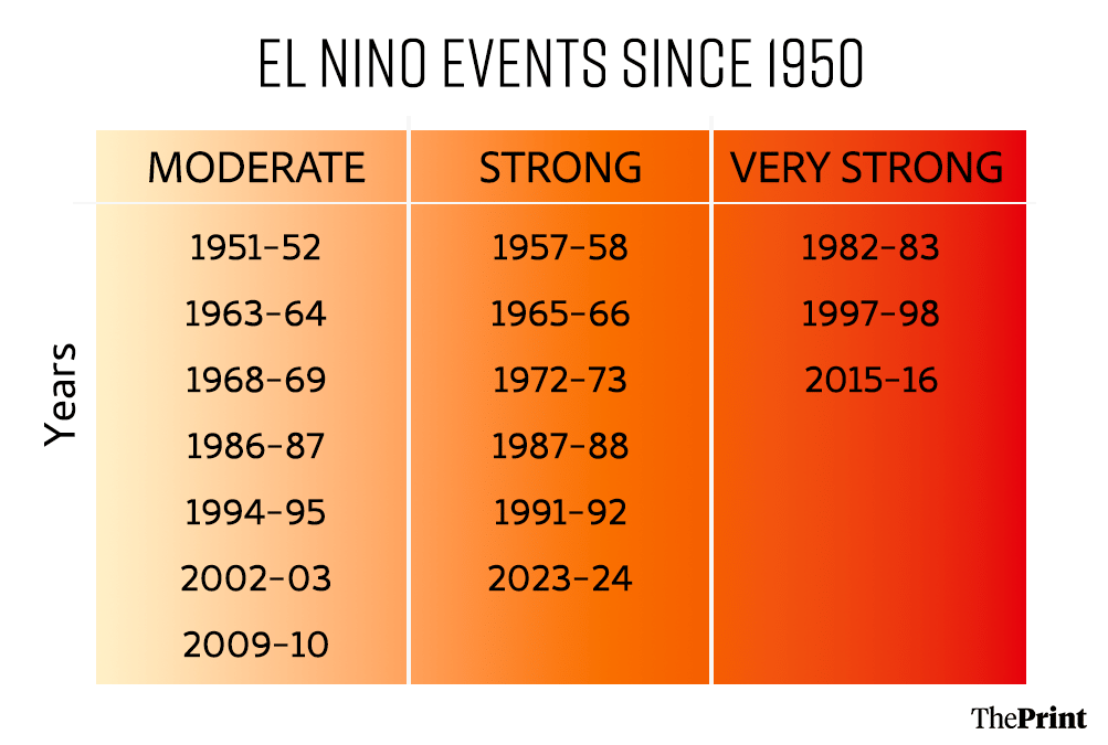
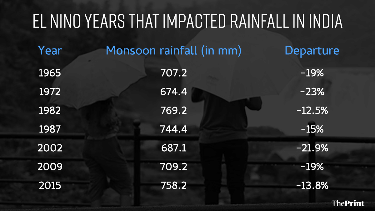
Since 1950 there have been 16 El Niño events, of which 7 have drastically impacted the Indian monsoon. During the other weather events, IMD data shows that the monsoon has either remained normal or reduced marginally.
However, the El Niño phenomenon has been tracked long before the emergence of modern weather forecasts. The term, meaning ‘little boy’ in Spanish, originated from Peruvian fishermen who observed warm waters in the Pacific Ocean in December. The Great Famine of 1877-1878 in India, which killed over 5 million people in British India, is also associated with strong El Niño conditions which led to low rainfall in South Asia.
As the world cautiously tracks the sea-surface temperatures (SSTs) in the equatorial Pacific Ocean as well as the direction of trade winds from east to west, some experts say the impacts of El Niño are already being felt.
“The El Niño is already impacting weather systems everywhere — the extreme heat this summer, the monsoon forecast and its late onset in India, we’re seeing it all around us,” said Akshay Deoras, a scientist at the Department of Meteorology, University of Reading.
Also read: What is Delhi’s O-Zone? A 9,700-hectare floodplain home to 91 unauthorised colonies
Indian monsoon failures due to El Niño
In the last 70 years, there have been three ‘very strong’ or super El Niño events globally – 1982-83, 1997-98, and 2015-16. The ‘strength’ of an El Niño is defined by the average change in sea-surface temperatures of the Pacific Ocean during that period.
An increase beyond 0.5 degrees Celsius above average is considered an El Niño event. In the three ‘super El Niño’ events, the sea-surface temperatures increased by more than 2 degrees Celsius above average.
In 1982 and 2015, the strong El Niño also impacted Indian monsoons, with below average rainfall and even drought-like conditions in some regions. However, in 1997, even though there were global atmospheric impacts from the phenomenon, the Indian monsoon remained normal, with no real change due to El Niño.
It is important to note that the El Niño does not result in a direct decline in Indian monsoons. During normal monsoons, a low-pressure area over the Indian subcontinent pulls in moisture laden winds towards it from the Indian ocean, which cause rainfall. However, during an El Niño, the increased warming over the Pacific Ocean leads to the moisture-laden winds being pulled that way instead, which eventually weakens the Indian monsoon winds.
But that is not the only thing influencing Indian monsoons. Another phenomenon called the Indian Ocean Dipole (IOD), a climate pattern, can draw warm waters towards the western Indian Ocean, leading to a strong Indian monsoon. The IOD can counterbalance the El Niño effect, and lead to rainfall in India and South Asia even during strong El Niño years.
“This is what happened in 1997. Even though El Niño was strong, we also had a positive IOD, which means that eventually there was only a 3% departure in the monsoon that year,” said Deoras. “So an El Niño year does not always mean drought or low monsoon.”
Also read: How a vaccine made from a patient’s own tumour can help keep skin cancer from returning
This year’s prediction
For 2026, the IMD forecast a ‘neutral’ IOD, meaning that its impact on Indian monsoon will be meagre.
Historical data shows that in the years when the IOD was unable to counteract the El Niño’s impact, India’s rainfall suffered heavily. India’s drought atlas over the last 100 years coincides precisely with El Niño Southern Oscillation (ENSO) years.
“The droughts in 2002, 1965, 1972, 1918, and 2009 were identified as the five most exceptional calendar year droughts in India,” found a 2024 study by IIT Gandhinagar.
The 2015-16 and 1997-98 El Niño events currently hold the record for the strongest ones till date, with sea-surface temperatures reaching 2.5 degrees Celsius above normal. However, the European Centre for Medium-Range Weather Forecasts predicts that this year’s sea-surface temperatures might top those, with predictions suggesting warming of over 3 degrees Celsius.
Added to a strong El Niño prediction is the existing context of fertiliser shortage in South Asia due to the impacts of the Iran war. The double whammy of lower than average monsoons and fertiliser availability challenges could lead to a weak agricultural output in India’s Kharif season, said a report by Investment Information and Credit Rating Agency, a credit rating agency affiliated to Moody’s Investors Service.
(Edited by Janaki Pande)