



Emblazoned on the line of vermillion flags billowing on the banks of the Lohit River, the blue seal of the four-clawed dragon warned Scottish politician William Dundas that his expedition had reached its end. “The southern frontier of Zayul on the borders of the Szechuan Province of the Chinese empire,” read the characters crudely inscribed on a wooden board, for the benefit of barbarians who might not recognise the logo. Local chieftains had been issued warrants of protection in the name of Zhao Erfeng—the commander who had conquered Lhasa the previous year, 1910—declaring their submission to their new ruler, the emperor in the Forbidden City.
For weeks now, outrage has been growing across India over news that the People’s Liberation Army troops have embedded themselves at multiple locations south of the Line of Actual Control in Arunachal Pradesh—this comes despite apparently successful diplomatic engagement which ended the long crisis that followed the Galwan Valley crisis of 2020.
Experts frequently assert these confrontations stem from differing perceptions of the border and LAC, yet there is too little understanding of what that means—leading many to conclude Beijing is negotiating in bad faith. The truth is more complex. Like the imperial cartographers who gifted—or cursed, if one wishes—India with their visions of its borders, Zhao Erfeng and his commanders carried their own maps, with a thick green line showing where their empire ended.
The lesson from Zhao Erfeng’s forgotten map is simple: Fighting on the LAC is a political choice, not the destiny of two great nations. Like all borders, the frontiers between India and China were made not from mountains and rivers, but imagination.
A map of nowhere
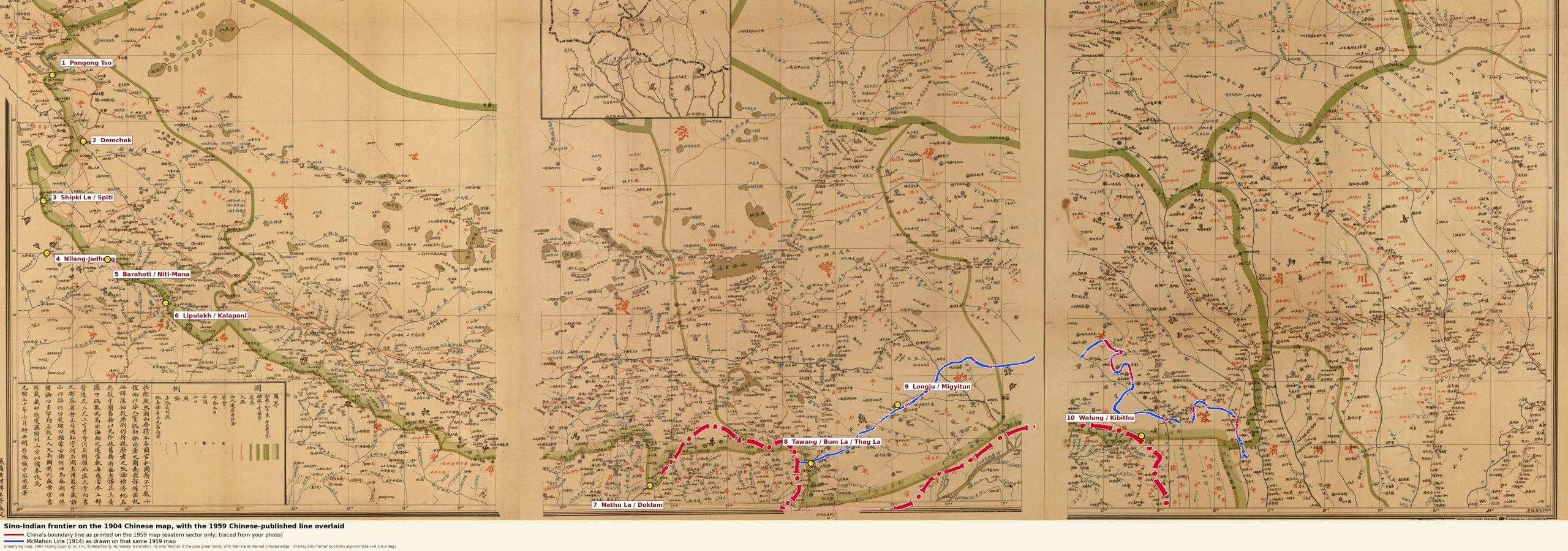
From the summer of 1904, as Francis Younghusband’s murderous assault on Lhasa was unfolding, China’s legation in Russia began working with the great cartographical house of Alexey Afinogenovich Ilyin in St. Petersburg to chart the borders of Tibet. The 1904 Xizang quan tu, which translates to the “Full Map of Tibet”, is now held in the Library of Congress—the very first with an explicit marking for 國界, or national boundary—was published under the signature of Chinese diplomat Hu Weide. A note states it drew on several sources, using imperial records and materials from the French expedition of Jules-Léon Dutreuil de Rhins and Fernand Grenard of 1890-1895.
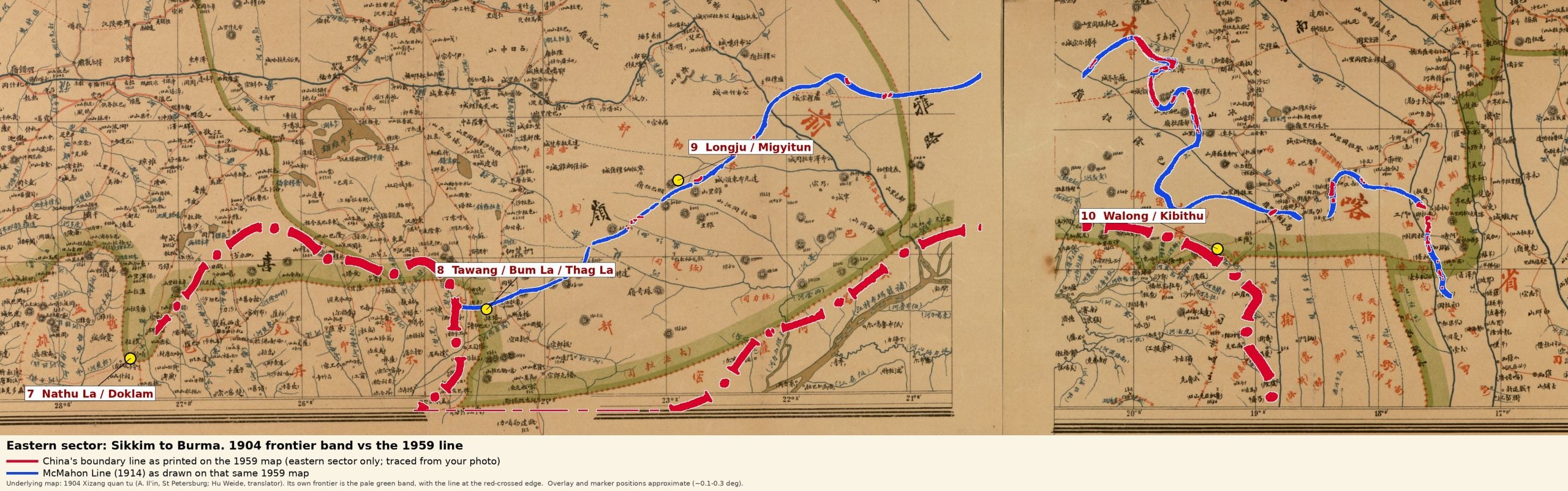
| Base map: Xizang quan tu (1904), A. Il’in, St Petersburg, Library of Congress Geography and Map Division. Overlay: boundary lines traced from the 1959 Chinese map submitted to India, from the private collection of Claude Arpi. Markers and overlay prepared with Claude (Anthropic) and positioned approximately
Since then, claims made by China have hewed closely to the border it asserted in the Xizang quan tu. From overlays made using Claude 5.5 in Map 1, it is clear the claims China asserted during border negotiations in 1959 ran well to the south of the border drawn in 1914 by British India’s Foreign Secretary, Henry McMahon (Map 2).
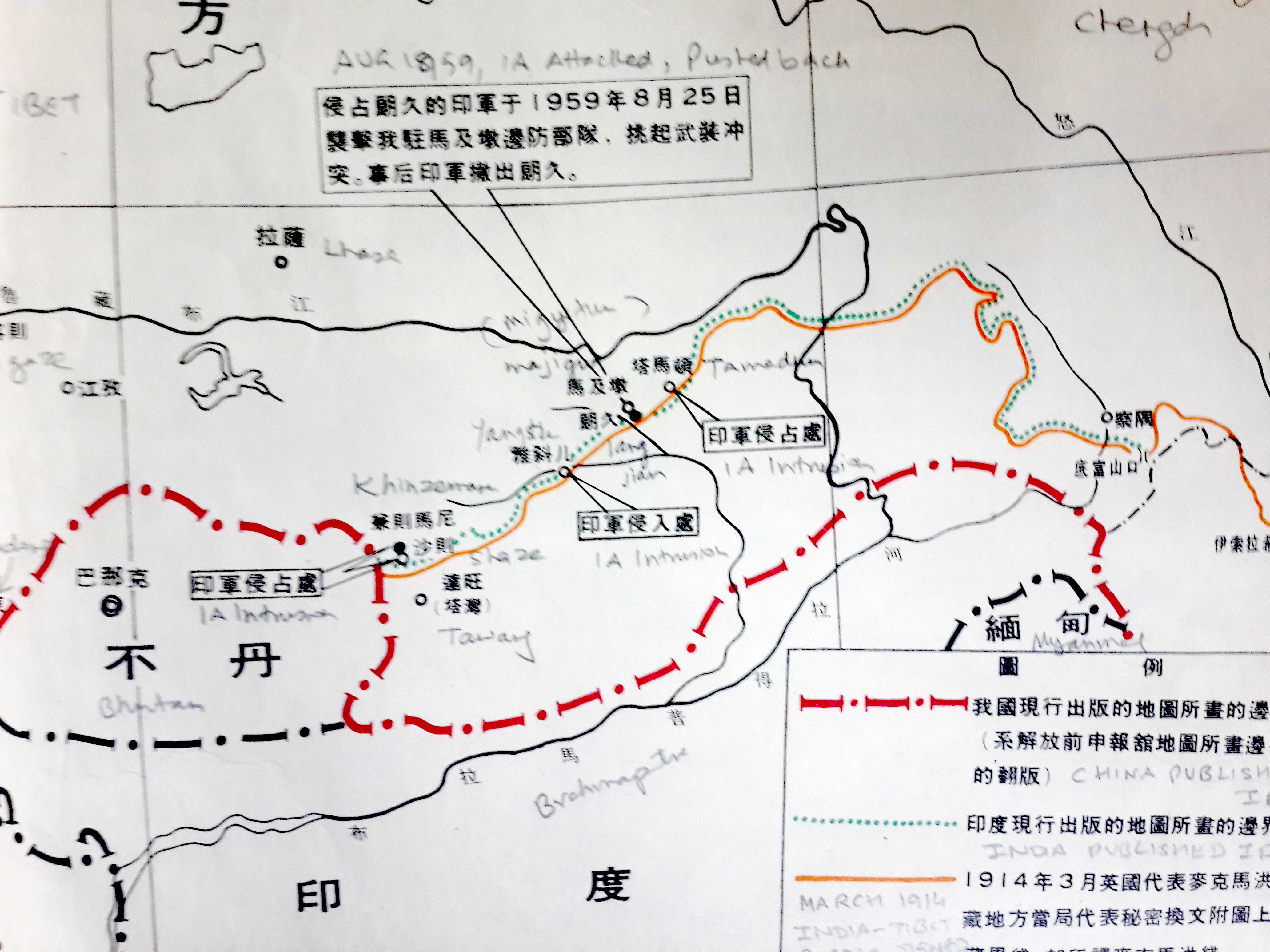
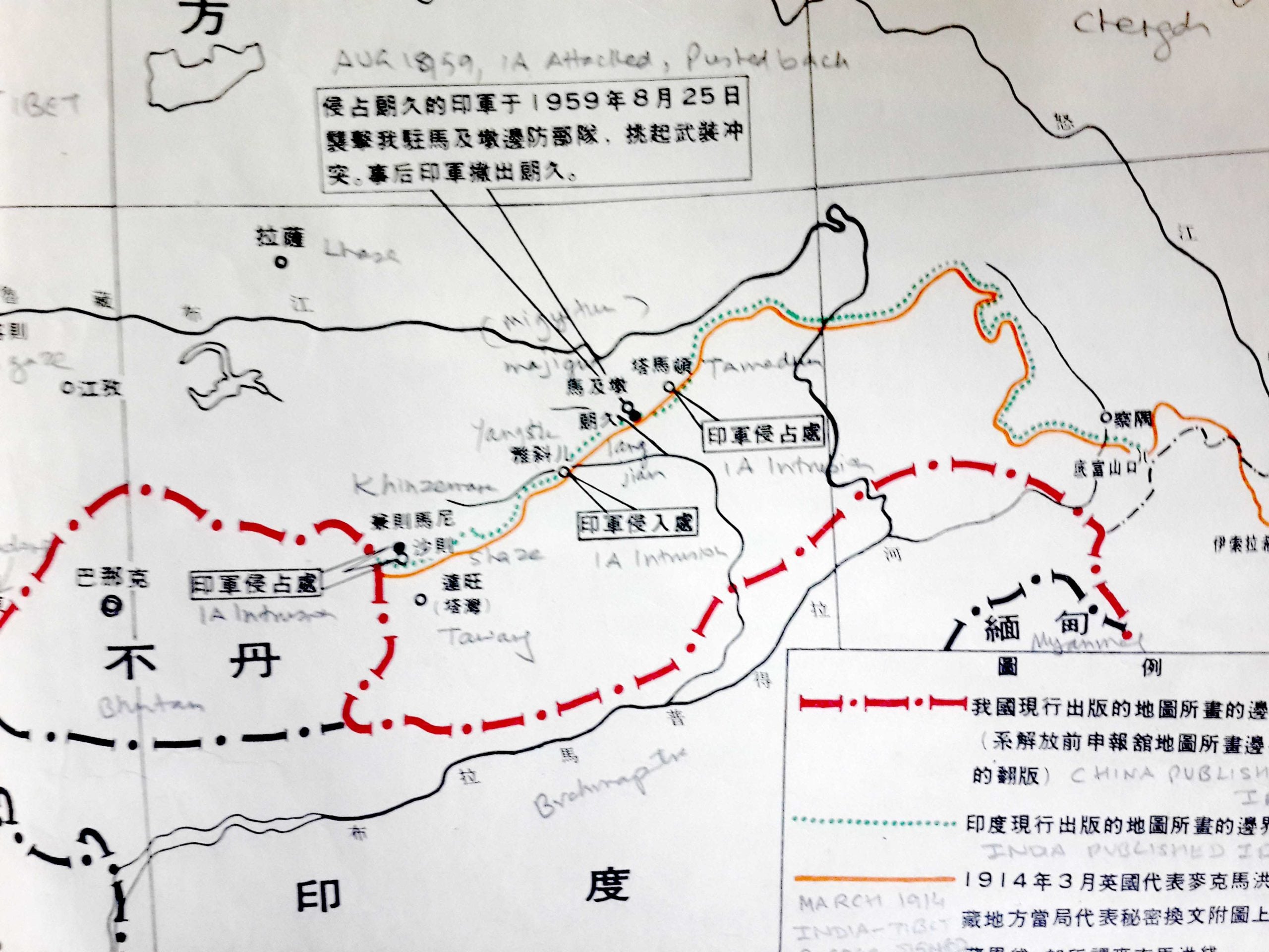
The 1904 border map in Ladakh—where no border was drawn by the British—also runs along much the same axis as the LAC today (Map 3). British India left behind no map of its borders with China in Ladakh and India, too, did not produce one until 1954, following up the cartographic exercise with troops on the ground (Map 4).
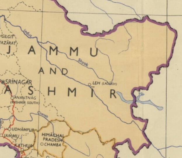
Yet, the Xizang quan tu elided over an important part of reality. Even though imperial China’s political life had been entwined with Tibet since at least the twelfth century, its suzerainty was notional. There were few imperial troops, and no actual border. Especially in regions like Kham, where real power rested with local strongmen and traders, who in turn maintained peace with ethnic groups like the Tagin, Adi, or Mishmi.
Lhasa, to take just one example, claimed suzerain power over Walong in Arunachal’s Anjaw district in the far east. There were only three ethnic-Tibetan hamlets in Walong, with just five homes. Among them, the Miju Mishmi only tolerated the Tibetans, on condition they pasture their cattle.
Also Read: China is fighting over names in Ladakh. India should notice who else is watching Beijing
An empire’s last gasp
The men bearing the flags of the four-clawed dragon, so the village chieftain of Mazanon told Dundas, had arrived in the lunar month of Tacheyi, in mid-1911, led by Chinese official La Toh, with some fifty sepoys carrying guns and a hundred coolies bearing their luggage. The troops crossed the Glei Dakhan pass, the 4,400-metre saddle that leads out of Tibet’s Nyingchi, and then crossed into the jungles around Walong.
This demonstration of sovereignty locked the two sides into a ritual that continues to be played out: each empire busied itself uprooting border pillars and markers the other put up.
Francis Younghusband’s assault on Tibet—set off by fears the Dalai Lama was negotiating a military alliance with Russia’s Tsars, through the Siberian-born courtier and monk Agvan Dorjiev—exposed the hollowness of both the suzerain and the vassal.
Tibetan soldiers, armed with little other than matchlocks and magical amulets, were mowed down in their thousands by British Army machine-guns. For its part, China proved utterly ineffectual in influencing the crisis and, upon discovering Great Britain had emerged as the primary power in the Himalayan region.
Languid imperial governance was now replaced by a determined effort to restore what remained of Beijing’s authority. The path was, ironically, opened by the British.Russia’s Catherine the Great had once briefly flirted with the idea of invading India, but was advised against it. Her hapless son, on the other hand, tried assembling a force of Cossack guerrillas for the expedition. Fearing an independent Tibet might encourage a revival of these dreams, the British recognised China’s suzerainty in 1906.
Following this, sweeping land and revenue reforms were initiated in Kham—and a subsequent rebellion was put down with genocidal violence by Zhao Erfeng. The campaign led imperial troops brushing up against the frontiers of British India.
Viceroy Charles Hardinge pushed back against an expensive deployment of troops in the mountains. The British navy, he argued, could bombard China’s ports when it wished. Figures in the imperial bureaucracy such as Arthur Hirtzel and former Lieutenant Governor of Bengal, Lancelot Hare pushed back, insisting China could in the future pose a threat to Assam’s lucrative tea estates.
Even as the debate raged, circumstance presented imperial hawks with a gift. Leading an expedition up Arunachal’s Siang Valley in March 1911, British officer Noel Williamson and tea garden doctor JD Gregorson were slaughtered with over forty servants, guards, and coolies after they rejected demands by the Adi tribe to leave their lands.
“Kebong Abors forbid going further. Saheb insists on going on into the village. My impression is we shall never return,” his servant wrote in a letter, which was received posthumously.
Four British Army brigades would hunt down the supposed perpetrators of the massacre. Local villages fought back, determined to punish the armed intrusion into their lands. The colonial military waged a war of brutal retribution, burning down entire villages until the Adi rebellion was crushed in 1912.
The bloodshed made clear that the peoples of the North-East borderlands, living beyond the pale of two great empires, did not care what lines on a map meant. For four decades, in the wake of the 1911 revolution that swept China’s last emperor from power, hope flickered that the kingdoms and chieftainships of the mountains might survive—and yet…
Also Read: How Chinese commentators are using Siang dam, Arunachal protests to revive territorial claims
The making of nations
Late in the spring of 1948, just months after the birth of their new nation, Apatani warriors armed with bows and arrows attacked the Assam Rifles outpost in Kure—not quite fast enough to catch the guards off guard. Three men were killed when the soldiers opened fire; later, the Assam Rifles shot dead two more men who resisted the burning down of their villages and granaries in time-honoured colonial tradition.
Five years later, Tagins attacked a government patrol in Achingmori, killing 47 people, including 27 Assam Rifles soldiers led by Major Ripudaman Singh.
Even though the military’s push for air strikes was rejected, the eminent soldier and administrator SM Krishnatry recorded that villages were burned down and livestock killed.
Lines had been drawn at the Shimla Convention in 1914, as the British Empire sought to capitalise on the weakness of China. The conference was called to create a new semi-independent buffer zone beyond the so-called Outer Line, the un-demarcated furthest boundary of the Raj.
The line drawn by McMahon in 1914 was rejected by China, which clung to its 1904 line. For its part, Great Britain did not publish its new borders until 1938. Tibet, meanwhile, refused to acknowledge the McMahon Line—which placed the Tawang Monastery in India—unless there was first a final border agreement with China.
From the map drawn in 1904, and those that followed it, it is clear the border China and India are fighting over was birthed by imperial intrigue, the imagination of bureaucrats, and the blood of communities who found themselves at war with nations they did not know existed.
To end the conflict, both the Chinese and Indians will have to accept that there is nothing inevitable, let alone sacred, about the lines dividing them.
Praveen Swami is a Contributing Editor at ThePrint. His X handle is @praveenswami. Views are personal.
(Edited by Insha Jalil Waziri)