


China is planning to construct its second major highway linking Tibet to Xinjiang, 65 years after the G219 highway was completed in 1957. G219 transgressed across the Indian territory in eastern Aksai Chin and the proposed highway cuts across it from the new bridge on the Pangong Tso and thereafter right across western Aksai Chin. This development has major political and military implications for India.
The South China Morning Post on 20 July reported that in addition to the existing highway, G219, China plans to construct a new highway – G695 – to connect Tibet and Xinjiang by 2035. The report highlighted that G695 is among 345 construction plans proposed in China’s new national programme, which aims to build a total of 461,000km (286,400 miles) of highway and motorway by 2035, to revive its faltering economy and boost consumer spending through infrastructure investment.
Alignment of G695
The approximate alignment of the proposed highway was mentioned in the media reports with reference to the counties through which it will pass: Maza in Xinjiang (130 km northwest of Karakoram Pass)—Zanda (opposite Himachal/Uttarakhand)—Burang (south of Mansarovar and 16 km from Lipulekh Pass on the LAC)—Gyriong (opposite Nepal)—Kamba ( 30 km north of Naku La in Sikkim)—Cona (30 km north of LAC in Tawang Sector)—Lhunze (70 km northeast of Cona). One expected the Ministry of Defence/Ministry of External Affairs to assess the alignment based on intelligence reports and terrain evaluation, only to be disappointed.
It was left to an amateur satellite imagery analyst who goes by the username ‘Nature Desai’ on Twitter to plot the approximate alignment on the map with respect to Eastern Ladakh based on OSINT and Chinese social media.
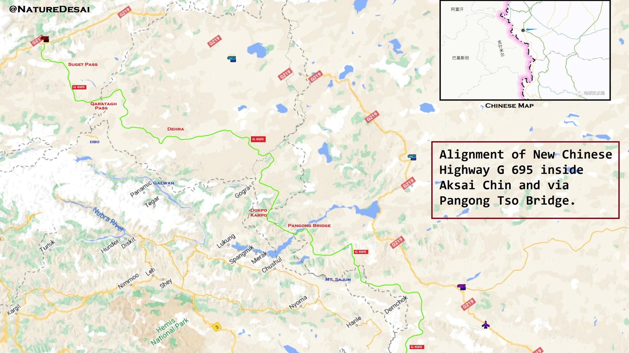
G695 is at an average distance of 20-50 km from the Line of Actual Control all along the border. In contrast, G219 was three to four times this distance. It will probably subsume all existing minor roads along its alignment. It is likely to be connected to the LAC and to G219 by existing/new lateral roads. China still has to overcome the innumerable problems of high-altitude terrain. However, it has the will, money, experience and modern technology to do so.
Also Read: The West is tired of China’s power games. India could take advantage
Political implications
China has a clear strategy to assert its sovereignty through the management/development of its border areas. President Xi Jinping has himself spelt out the theory for the defence of border areas: “Governing border areas is the key for governing a country, and stabilising Tibet”. This ongoing process has recently been formalised into a “Land Border Law” enacted on 23 October 2021 to consolidate China’s hold/claims over territories, which are occupied, disputed or vulnerable to insurgencies due to non-Han populations. To this end, it is constructing modern villages and roads/railway lines in border areas of Tibet and Xinjiang. As per Professor M Taylor Fravel, eminent China scholar at MIT, the modern villages and infrastructure construction are part of a Chinese plan of rural revitalisation, put in place in 2017 with a budget of $4.6 billion. A total of 624 model ‘Xiaokang’ (which literally means ‘well-off’) villages have been constructed in Tibet on/near the borders. The Chinese aim is clear—to ensure border control/consolidation while promoting economic development and tourism.
As per Jayadeva Ranade, former RA&W additional secretary, the border villages are also intended to create a buffer along the border to be inhabited by people loyal to the Chinese Communist Party and will provide a secure base for military operations in areas where the Tibetan population may turn hostile.
G695 fits well into the above plan. India must lodge a strong protest against the construction of the highway through our territory under the illegal occupation of China. We must not repeat the mistake made with respect to G219 in the 1950s.
The G219 highway, constructed from 1951 to 1957 through eastern Aksai Chin, had caught the Indian government by surprise. A feeble protest was lodged only on 18 October 1958 when an ‘informal’ note was given by the foreign secretary to the Chinese Ambassador: “The attention of the Government of India has recently been drawn to the fact that a motor road has been constructed by the Government of the People’s Republic of China across the eastern part of the Ladakh region of the Jammu Kashmir State, which is part of India.” The construction of G219 led to a reciprocal ‘forward policy’ by both sides to flag the frontier region and was one of the major reasons for the 1962 War.
It is surprising that India has not lodged a formal protest with respect to the proposed highway. On 21 July, the spokesperson of the Ministry of External Affairs, Arindam Bagchi, brushed aside the queries of the media, saying: “You were asking about a new highway, there is an SCMP report.” Linking his comment with another query with respect to Doklam he elaborated, “Look, I don’t want to get into commenting on media reports. I don’t even know accuracy, etc but let me make a broader point, particularly in the context of Doklam. Please be assured that government keeps a constant watch on all developments having a bearing on India’s security and takes all necessary measures to safeguard the same. I’ll make that as a general comment.”
The Narendra Modi government must not underplay this issue for the sake of improving bilateral relations. It had objected to the new bridge across Pangong Lake on the Chinese side of the LAC because it was in the territory illegally occupied by China. Why should it now dither when a highway is planned to be constructed across a vast swath of our territory? Moreover, it is not a “media report” but an official plan—National Highway Network Plan—authorised by the central government of China, so there’s no question about its authenticity.
Also Read: What the Chinese govt, media told people on two years of Galwan
Military implications
Since the standoff in Eastern Ladakh beginning in May 2020, China has been developing its border infrastructure at a rapid rate. The accommodation capacity has been increased from 20,000 troops in 2020 to 1.2 lakh troop. Captive solar energy and small hydel power projects have been constructed along the LAC, which enhances winter sustenance capability manifold. China has deployed approximately six combined arms brigades from the Xinjiang Military District, which are rotated after one year. The People’s Liberation Army is well prepared for the long haul.
However, due to the absence of or poor quality of north-south roads, it is extremely difficult for the PLA to carry out any inter-sectoral movement between Depsang Plains, the Galwan Valley, Chang Chenmo, north of Pangong Tso, south of Pangong Tso and Indus Valley Sectors. Any inter-sectoral movement requires 100-200 km movement east to G219 before affecting the north-south movement and then travelling the same distance west to the LAC. G695 will facilitate inter-sectoral movement and logistics of the PLA. It will also allow reserves and logistics to the centrally located apart from the overall development of the border region.
Also Read: India-China military talks have run their course. Live with status quo or sign a new agreement
Lessons for India
The lesson for India is that territorial integrity is best safeguarded by infrastructure development and settlements. It defies logic that Indians still have to get inner line permits to visit even the places of tourist interest[8] in the vicinity of the northern borders. We have had a Border Area Development Programme since 1986-87 for the security and well-being of the border population. However, development is marred by inadequate budget. In 2020-21, the government had allocated Rs 783.71 crore for the development of border villages and towns, out of which Rs 190 crore ($2.5 million) were allotted for the India-China border. Compare this with China’s $4.6 billion—$1.53 billion per annum for three years for 624 villages in Tibet. The same is true for a number of hydel projects approved for Ladakh and Arunachal Pradesh.
The government has given a great impetus to the development of border roads but the progress is very slow due to a lack of adequate budget, modern technology and tardy execution. China has set a target of 13 years to develop the over 2,000-km-long G695. It took us 20 years to develop the Atal Tunnel to avoid the Rohtang Pass and there are four more tunnels required to be constructed, on which work has not yet started before the Manali-Leh road becomes all-weather.
Open up the borders to tourism. No visit to South Korea is complete without going to the 38th parallel, the border with North Korea. The infrastructure and defences are awe-inspiring and a source of confidence for the domestic population. Do away with the colonial practice of inner line permits. Impose hefty entry/environmental taxes on visitors to earn revenue for infrastructure.
I recommend that apart from lodging a strongly worded protest against the proposed G695, India must immediately announce and vigorously execute the construction of a similar highway all along our border in a faster time frame.
Lt Gen H S Panag PVSM, AVSM (R), served in the Indian Army for 40 years. He was GOC in C Northern Command and Central Command. Post-retirement, he was Member of Armed Forces Tribunal. He tweets @rwac48. Views are personal.
(Edited by Srinjoy Dey)