


Guwahati: In a historic move last week, the Narendra Modi government at the Centre announced that it was withdrawing the Armed Forces Special Powers Act from several areas of Assam, Nagaland, and Manipur as a result of the “improved security situation”.
A statement from the Ministry of Home Affairs said there had been a 74 per cent fall in incidents of militancy in the Northeast in 2021 in comparison to 2014.
AFSPA gives sweeping powers to the armed forces in places declared as “disturbed areas”. This included arrests without warrant, and even killings, in certain situations.
Demands for AFSPA’s repeal had been growing since a “botched” security operation in Nagaland’s Mon. Six civilians were killed in the Army ambush and seven civilians and a jawan in the protests that followed.
ThePrint illustrates, with the help of maps, which areas are now exempt from AFSPA.
Also Read: Modi govt reduces areas under AFSPA in Nagaland, Manipur & Assam, 3 months after Mon incident
Assam
At the height of the ULFA-led militancy in Assam in 1990, the MHA had declared the whole state a disturbed area.
On 28 February 2022, the last time the Act was extended in the state, its entire area had been declared ‘disturbed’.
This status changed last week when the central government decided to withdraw AFSPA from 23 districts in Assam — Dhemaji, Lakhimpur, Majuli, Biswanath, Sonitpur, Nagaon, Hojai, Morigaon, Kamrup Metro, Darrang, Kamrup, Nalbari, Barpeta, Goalpara, Bongaigaon, Dhubri, South-Salmara Mancacha, Kokrajhar, Chirang, Baksa, Udalguri, Karimganj, Hailakandi — and the Silchar sub-division of Cachar district. As a result, AFSPA stands removed from 46,713.06 sq. km, or nearly 60 per cent, of the total geographical area of Assam.
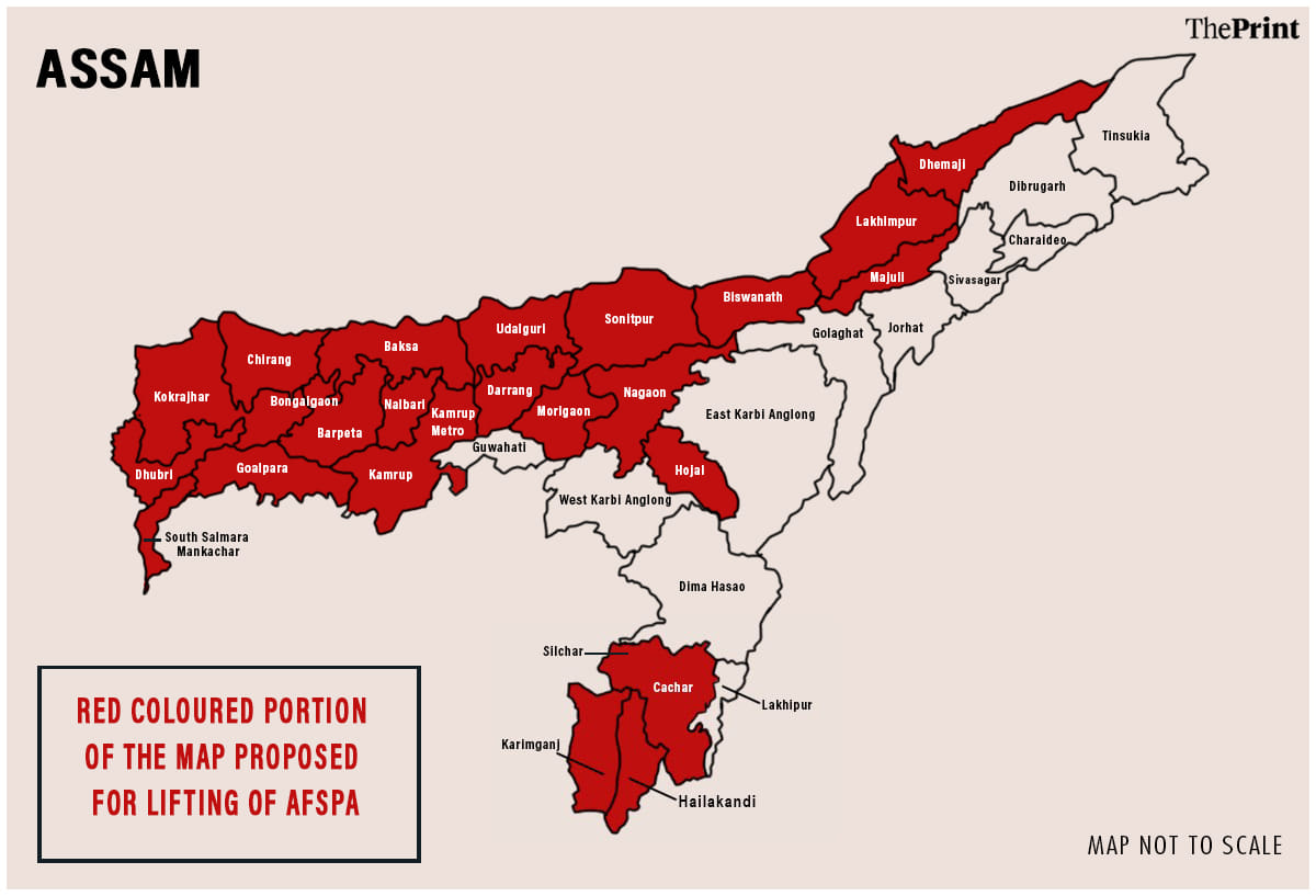
The Act still remains in force in Tinsukia, Dibrugarh, Charaideo, Sivasagar, Jorhat, Golaghat, Karbi Anglong, West Karbi Anglong, Dima Hasao, and Lakhipur sub-division of the Cachar district.
A note the Assam government issued last week after the Centre’s announcement said the Army is currently deployed in only five districts of the state: Tinsukia, Dibrugarh, Charaideo, Karbi-Anglong, and Dima-Hasao.
Manipur
In Manipur, AFSPA was imposed in the Naga-dominated areas of Ukhrul, Senapati, and Tamenglong in 1958, and then extended to Churachandpur and the Kuki-Zomi in the 1960s. It was extended later to the valley, where Meiti-based armed insurgency had taken root.
In December, the central government decided to extend AFSPA to the entire state, except for Imphal Municipal areas.
Last week, the central government withdrew the “disturbed area” status under the Act from 15 police stations across six districts of Imphal.
The areas where AFSPA now stands removed are Imphal, Lamphel, City, Singjamei, Sekmai, Lamsang, Patsoi police stations in Imphal West District; Porompat, Heingang, Lamlai, Irilbung police stations in Imphal East District; and the Bishnupur, Kakching, Thoubal and Jiribam police stations in the districts with the same respective names.
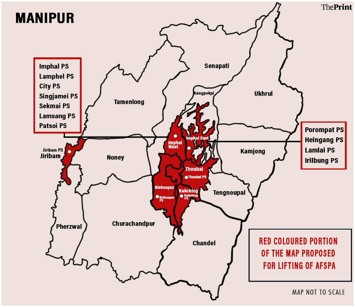
Significantly, all the police stations from where AFSPA was withdrawn are located in the valley, where the dominant ethnic Meitei population resides.
To put this into context, geographically, hilly areas, which comprise 90 per cent of the Northeastern state, are largely inhabited by tribals, while the ethnic Meitei group dominates the valley areas, which make up 10 per cent of the total land area.
Forty of the 60 assembly seats in Manipur — which recently voted in a Bharatiya Janata Party government under Chief Minister N. Biren Singh — come from the valley, while the hills account for the remaining 20. This makes the Meiteis a politically influential group. The Meitei-dominated valley seems to have contributed significantly to the BJP’s victory this past election — 26 of the BJP’s 32 seats in the assembly elections last month came from there.
Nagaland
The AFSPA was passed in Parliament at a time when an armed movement was waging in Nagaland, which started from the setting up of the Naga National Council. AFSPA was eventually imposed in the state.
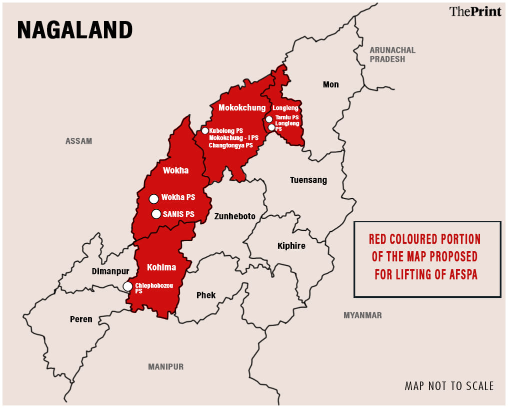
In December 2021, AFSPA was extended to cover the entire state of Nagaland. The Act has now been removed from Tuensang, Shamatore, and Tseminyu districts in the state, and eight police stations in four other districts. These are Chiephobozou in Kohima district; Wokha and Sanis in Wokha district; Tamlu and Longleng in Longleng district; and Kubolong, Mokokchung-I and Changtongya in Mokokchung district.
Why withdraw AFSPA now?
The ministry statement said there was a 60 per cent drop in the deaths of security personnel and an 84 per cent dip in civilian deaths, showing an “improved security situation” in the states.
The MHA press release said the decision was taken on the recommendation of “a committee constituted in this context for withdrawal of AFSPA in a phased manner”.
(Edited by Uttara Ramaswamy)
Also Read: Intel behind ‘botched’ Nagaland ambush will be probed too as tensions over civilian deaths grow