



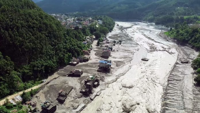
New Delhi: The next 48 hours will be crucial for Bihar and eastern Uttar Pradesh, which are likely to face the aftermath of the Bhote-Koshe flooding in Nepal, the National Disaster Response Force and the Central Water Commission have warned. Experts said that while a flood risk continues, the consolation is that the flow of the Narayani river has not risen to an alarming level on the Indian side.
A senior CWC official told ThePrint on Thursday that they were carefully monitoring water level discharged from the Nepal side to ensure that there is ample time for advance preparations in case a flood-like situation were to arise on the Indian side.
“We have been monitoring the water discharge levels and are also keeping track of the river water levels on the Indian side. We are releasing real time updates to the NDRF and the state disaster management teams,” the official said.
At 9 pm on Wednesday, the CWC had released its first advisory warning of a sudden rise in water level in the Trishuli river at Furke Khola in Nepal, around 160 km from the Indian border. They said that this rise was due to suspected flash flood activity near the Nepal-China border.
“The impact of the flood is likely to travel downstream in the Gandak river, in India,” the advisory read.
Just hours after the floods in Nepal, caused by a glacier collapse in the upper reaches of the Himalayas, the Indian authorities issued flood warnings for parts of Bihar and UP. According to NDRF statements, state governments have already been directed to evacuate districts that are closer to the Nepal border.
“We are constantly monitoring what could be the impact of the Nepal floods on the India side. We already have a reserve force, which is ready to be deployed in case the situation worsens,” said Narendra Singh Bundela, NDRF Inspector-General.
Also read: Nepal flash floods: What’s an ice-rock avalanche?
Why the alert for India?
Districts including East Champaran, West Champaran, Gopalganj, Saran, and Muzaffarpur in Bihar, and Maharajganj and Kushinagar in UP are at the greatest potential risk, experts said.
The reason behind a potential Indian impact is because the floodwaters from Nepal’s Bhote-Koshi-Trishuli system ultimately become the Narayani-Gandak river system upon entering India. This then goes on to join the Ganga, but the impact there is likely to be negligible.
Mahesh Palawat, Vice-President (meteorology and climate change) at the Skymet Weather Services, said that while the flood risk in India continues, the flow of the river as it has reached this side of the border has been coming down.
CWC data shows that water discharge from Valmikinagar barrage declined from 1.50 lakh cusecs at 11pm on Wednesday to 1.04 lakh cusecs on Thursday morning. Palawat said that there was also a forecast of moderate rain in parts of UP, but that is unlikely to have any impact on river water levels.
“They (the Nepal authorities) have been releasing water from the Gandak barrage since last night, but the good news is that once water hits the plains, it tends to scatter well and the risk of intense floods is not as high as it is in the mountains,” Palawat said.
(Edited by Aamaan Alam Khan)