


When India stops its unutilised share of Indus water from flowing into Pakistan, as Union Water Resources Minister Nitin Gadkari announced last week, it will hurt, among others, two major dams that serve the purposes of irrigation and hydroelectricity across the border.
One of them, Tarbela, is believed to be the largest earth-filled dam in the world.
The rivers that comprise the Indus Water System are split between India and Pakistan under the Indus Water Treaty (IWT) brokered by the World Bank in 1960.
Under the treaty, the waters of the three eastern rivers — Beas, Sutlej and Ravi — belong to India, while those of the western rivers — Indus, Jhelum and Chenab — serve Pakistan.
According to the IWT, India can use 33 million acre-feet (MAF) of water from the eastern rivers, but had so far been using only 31 MAF, allowing the rest to flow into Pakistan.
But that changed in 2016 when, after the Uri attack, the Narendra Modi government decided to stop the flow of these waters and divert them for use in Jammu & Kashmir and Punjab through three projects: The Shahpur Kandi dam project, the UJH dam project in Jammu & Kashmir, and a second Sutlej-Beas link in Punjab.
This was meant to send a strong message to Pakistan as the terrorists who carried out the attack on the Uri Army camp came from across the border. Gadkari’s statement, made in the wake of the 14 February Pulwama attack, also claimed by a Pakistan-based outfit (Jaish-e-Mohammed), was meant in the same vein.
As India goes through with its promise to “not let water and blood flow together”, ThePrint taps satellite imagery for a look at the dams and barrages in Pakistan that are dependent on Indian rivers.
Pakistan has four major dams, two of which draw water from Indian rivers. It also has 12 link canals (canals that connect rivers) that connect rivers from north to south — of these, three serve Pakistan’s strategic interests as well.
Also read: India won’t break Indus Water Treaty, but stop giving excess water to Pakistan
Tarbela dam
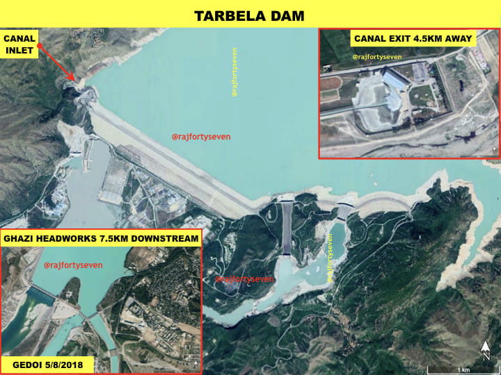
Tarbela dam, located near Swabi in Khyber Pakhtunkhwa, is believed to be the largest earth-filled dam in the world as well as the largest dam by structural volume.
It impounds the Indus river, creating a reservoir of 13.69 cubic kilometres (cu km) and a catchment area of 168,000 square km.
It has 17 turbines, with a maximum capacity of 6,300 MW.
The Tarbela dam has one canal exiting 4.5 km to its west, and another 7.5 km downstream. Both canals are used for irrigation systems, which form part of the Indus Basin Project as laid out under the IWT.
Mangla dam
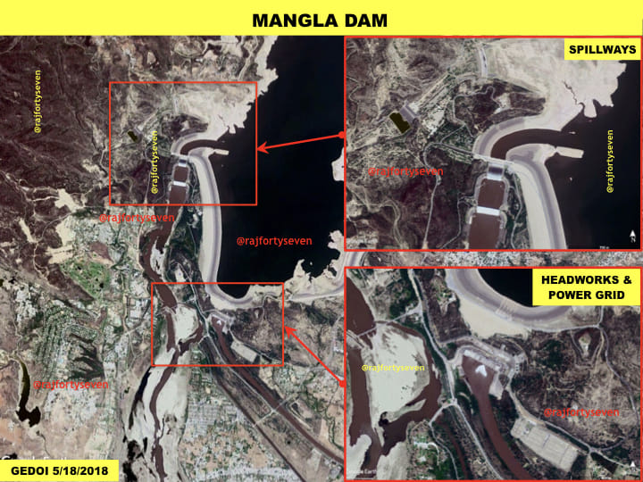
Mangla dam is located in the Mirpur district of Pakistan-occupied Kashmir (PoK) on the Jhelum.
It impounds the river to create a lake that holds 9.12 cu km of water and has a surface area of 250 sq km.
The Mangla dam has 10 turbines with a capacity to generate a maximum of 1,500 MW.
The dam has two spillways and a canal exit, which is used for irrigation purposes and also forms a part of the Indus Basin Project.
Marala barrage
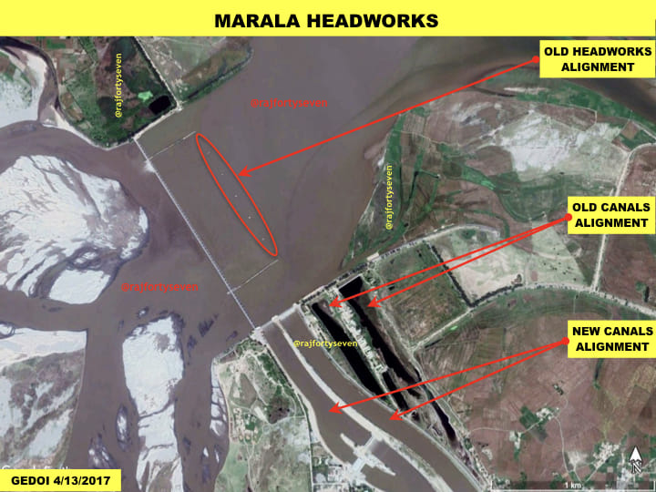
Barrages are smaller dams that are built to divert water for irrigation, instead of generating hydel energy.
Marala, located 20 km north of Sialkot city, is a large hydro-engineering project situated on River Chenab.
The barrage had to be shifted by more than 300 m due to heavy sediments in the headworks system (the apparatus for controlling the flow of water in a river or canal).
This barrage provides two irrigation link canals — the Marala-Ravi canal and the Bambanwala-Ravi-Bedian-Depalpur canal.
The Marala-Ravi link canal is almost 100-km long and has a capacity of 22,000 cusecs (cusec is the flow of one cubic foot per second), whereas the Bambanwala-Ravi-Bedian-Depalpur canal is 158-km long with a capacity of 2,200-4,200 cusecs.
Both canals provide irrigation in the plains of Punjab, as well as form a part of the Pakistan army defence posturing in the area.
Many Pakistani army units have their defences along these canals, which are meant to serve as obstacles in the face of an Indian offensive.
Rasul-Qadirabad-Balloki-Sulemanki
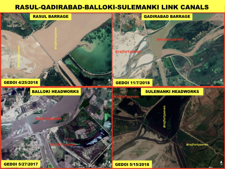
The four barrages located on Jhelum, Chenab, Ravi and Sutlej transport water for irrigation purposes throughout Pakistan Punjab.
The double canal emanating from Baloki headworks can flood areas to its west from below Chunian to Okara in Punjab, a plan believed to be aimed at blunting potential Indian armoured pincers.
The Sulemanki headworks, which is barely 2 km from the Indian border, supports three primary canals of the country: Pakistan Canal, Fordwah canal, and Eastern Sadiqia canal.
These three canals form a major part of Pakistan’s defence scheme, and cover areas right up to Fort Abbas on the countries’ border.
The Rasul-Qadirabad-Balloki-Sulemanki link canals total nearly 209 km, with a total capacity of 19,000 cusecs for the Rasul-Qadirabad branch, 18,600 cusecs for the Qadirabad-Balloki branch, and 15,400 cusecs for the Balloki-Sulemanki branch of the link canals.
Also read: Govt releases details on 3 river projects to divert waters away from Pakistan
Trimmu-Sidhnai-Mailsi-Bahawal
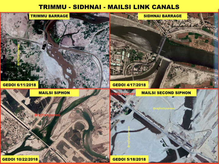
The Trimmu-Sidhnai-Mailsi-Bahawal barrages and siphon are mainly meant for irrigation purposes, carrying waters from the western rivers to the eastern side.
These canal networks provide waters to the more arid areas of western Punjab and eastern Sindh province.
The Trimmu-Sidhnai-Mailsi-Bahawal link canals total about 264 km in length, and have a capacity of 11,000 cusecs for the Trimmu-Sidhnai branch of the link canal and 10,100 cusecs for Sidhnai-Mailsi.
The latest satellite imagery from 2018 indicates a second siphon is being constructed with an additional bridge at Mailsi in Pakistan Punjab.
Indian plans
The dams on the rivers Ravi and Sutlej, like Ranjit Sagar and Pong, respectively, collect a lot of additional rainwater that is not utilised by India at all.
This water is released, at 12,000 cusecs, in a calibrated manner into the rivers that flow into Pakistan within a few kilometres from the dam sites.
When it stops the supply of water to Pakistan, India plans to utilise it for farming in J&K and Punjab, which also require the water urgently.
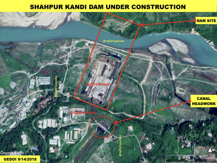
Construction of one of the projects that seek to divert the waters is underway and can be observed through satellite images.
It is being built at Shahpur Kandi about 7 km upstream of Madhopur headworks and the same distance downstream from the Ranjit Sagar dam.
The dam will have seven Kaplan-type generators with a capacity of 206 MW.