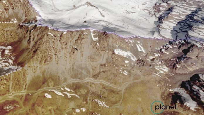
New Delhi: Over the past year, Indian and Chinese military have been beefing up their positions and infrastructure on Arunachal Pradesh’s Yangtse plateau, which witnessed a fierce clash between the two sides earlier this month, latest satellite images reveal.
A series of high-resolution satellite images put out by Canberra-based think tank Australian Strategic Policy Institute (ASPI) show both armies initiated major construction projects along the Line of Actual Control (LAC) in the region over the last 12 months — from multiple defence outposts to key access roads within a few hundred metres of the LAC.
With all eyes on the eastern Ladakh border, where India and China have been engaged in a standoff since May 2020, these satellite images highlight the dramatic shift in the region over the past year.
“Although Indian forces occupy a commanding position along the ridgeline, their position is not impregnable, especially in a scenario of open conflict where these current positions may not hold up to a concerted assault,” reads the report by ASPI.
Also Read: Why Yangtse in Tawang sector is the sore point China keeps returning to
What the images reveal
The report, which aims to contextualise India-China border tensions by examining the terrain in which the clashes took place, mentions India’s defence strategies in the region, including a network of six frontline outposts of the Indian army, consisting of a few buildings and layers of stone walls, along the LAC.
It also notes a forward base, approximately 1.5 km from the LAC.
While citing numerous Indian armed forces basings in the valleys below the Yangtse plateau — connected by steep dirt tracks — the report adds that the Army has over the past year restored many roads on the Indian-controlled side of the plateau, besides constructing new dirt tracks.
The report also suggests that though India has a dominant position along the ridgeline, its position is vulnerable, especially in case of open assault since access roads to many of the larger Indian Air Force (IAF) bases in the region are extremely steep dirt tracks, vulnerable to erosion.
“Satellite imagery shows that these roads are already suffering from erosion and landslides due to their steep grade, environmental conditions and relatively poor construction, and in open conflict, attacks on these dirt tracks would easily leave frontline positions cut off from resupply.”
On the Chinese positions and buildup, the report says that while their positions are much lower on the Yangtse plateau, the People’s Liberation Army (PLA) has over the past year made greater investment in infrastructure and construction of roads in the region than the Indian Army.
“China has upgraded several key access roads and constructed a sealed road leading from Tangwu New Village to within 150m of the LAC ridgeline, enhancing their ability to send troops directly to the LAC. There is also currently a small PLA camp at the end of this road,” notes the report, while exploring how these developments on both sides of the Yangtse plateau in Arunachal Pradesh’s Tawang sector led to the clashes earlier this month.
It further hints that it was the “construction of this new road that enabled Chinese troops to surge upwards to Indian positions during the 9 December skirmish”.
Noting that China was strategically disadvantaged in the region, the report suggests that it compensated for this ‘tactical disadvantage’ by swiftly deploying land forces in the area.
The report claims China’s lower position along the plateau and more Indian troops on the commanding ridgeline along the LAC puts the PLA at a disadvantage in the case of small clashes such as the ones reported on 9 December, but the dynamic shifts in the case of more significant clashes.
“But in a more significant conflict, the durable transport infrastructure and the associated surge capability that the PLA has developed could prove decisive, especially in contrast to the less reliable access roads that Indian troops would be required to use,” the report by ASPI argues.
(Edited by Amrtansh Arora)
Also Read: Did PLA force Galwan captives to make ‘confessions’? Footage surfaces in India-China video war


