



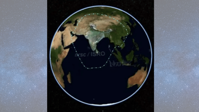
New Delhi: When people open Google Maps to find their way through a city, track a delivery or check the location of a vehicle, they often refer to the technology as GPS. But the American Global Positioning System is not the only satellite network capable of providing location services. India has its own regional alternative, called Navigation with Indian Constellation, or NavIC.
Developed by the Indian Space Research Organisation (ISRO), NavIC is designed to provide independent positioning, navigation and timing services across India and an area extending approximately 1,500 km beyond its borders. Its importance goes beyond helping people navigate roads. The system has potential applications in transport, maritime operations, disaster management, telecommunications and strategic activities.
However, maintaining an independent navigation network has proved challenging. ISRO is scheduled to launch its NVS-03 navigation satellite aboard the GSLV-F18 rocket from Sriharikota at 11.51 pm on 30 October. The mission is part of an effort to strengthen the constellation and improve the continuity of NavIC services.
What exactly is NavIC?
Originally called the Indian Regional Navigation Satellite System, NavIC is India’s independent satellite-based navigation system. Its name was introduced in 2016, when the original constellation was completed.
Unlike GPS, which provides global coverage, NavIC is a regional system. It was designed to serve India and the surrounding region, extending roughly 1,500 km beyond the country’s geographical boundaries.
The system was originally designed around seven satellites: three in geostationary orbit and four in inclined geosynchronous orbit. These satellites work with a network of ground stations that monitor the constellation, generate navigation data and maintain the accuracy of the signals.
NavIC provides two categories of services. The Standard Positioning Service is available to civilian users, while the Restricted Service is intended for authorised strategic users. ISRO has designed the civilian service to provide positioning accuracy better than 20 metres under specified conditions.
How does it work?
Satellite navigation systems determine a receiver’s location by measuring the time taken for signals to travel from satellites to the device.
Each navigation satellite transmits information about its position and the precise time at which a signal was sent. A receiver uses the time difference between transmission and reception to estimate its distance from the satellite. By combining measurements from multiple satellites, it can calculate its position.
At least four satellites are generally needed to determine a receiver’s three-dimensional position and correct for its own clock error.
This is why atomic clocks are essential. Even a tiny timing error can translate into a significant positioning error. NavIC satellites carry highly accurate clocks to ensure that their signals provide reliable timing information.
The system is also designed to work alongside other satellite navigation networks, including GPS, Russia’s GLONASS, Europe’s Galileo and China’s BeiDou.
Why does India need its own GPS alternative?
The main reason is strategic independence.
GPS is operated by the United States, while other major navigation systems are controlled by their respective governments. Although civilian signals are widely available, India cannot control the decisions made by foreign operators.
ISRO has said that NavIC was developed to reduce dependence on foreign satellite navigation systems, particularly for strategic requirements. An independent network gives India greater control over the availability of navigation and timing services within its coverage area.
There are also civilian and economic applications. NavIC can support vehicle tracking, maritime navigation, fleet management, disaster response and location-based services. Accurate timing signals are important for several sectors, including communications and infrastructure.
However, having a domestic system does not mean India must stop using GPS. Devices capable of receiving signals from multiple navigation constellations can combine them to improve positioning. NavIC is intended to provide an additional independent source rather than necessarily replace existing systems.
What is NVS-03 expected to change?
NVS-03 is the third satellite in ISRO’s second-generation navigation satellite series. The agency says the new-generation satellites are intended to maintain continuity of NavIC services while introducing additional capabilities.
The satellite will carry an indigenous atomic clock alongside procured clocks. It will also transmit signals in the L1 frequency band, in addition to the existing L5 and S-band signals.
The L1 band is significant because it is widely used by other satellite navigation systems and can make NavIC compatible with a broader range of receivers. The first second-generation satellite, NVS-01, launched in May 2023, also introduced an indigenous atomic clock.
NVS-03 is part of a planned series of five second-generation satellites, NVS-01 to NVS-05. Its launch is an important step, but the satellite will need to reach its intended orbit, undergo testing and be commissioned before it can contribute to operational services.
Can NavIC replace GPS?
Not entirely, at least not in the sense of providing the same global coverage. NavIC is a regional system, and its primary purpose is to serve India and neighbouring areas.
Its immediate challenge is ensuring that enough healthy satellites are available to provide dependable positioning services. Technical problems with navigation satellites and their clocks have affected the system’s ability to maintain its intended capabilities.
The NVS-03 mission is therefore important, but one launch cannot resolve every challenge. ISRO will need to deploy and maintain the remaining next-generation satellites, ensure the reliability of their clocks and ground infrastructure, and encourage manufacturers to build compatible receivers.
India has already established an independent navigation system. The larger task now is to make it consistently reliable and widely usable. NavIC does not need to eliminate GPS from Indian devices to serve its strategic purpose. It needs to ensure that India has a navigation network it can depend on even when access to foreign systems cannot be taken for granted.