



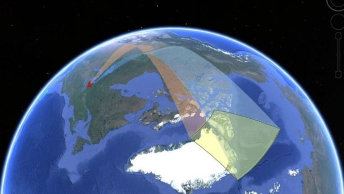
New Delhi: A Cold War-era radar technology is making a comeback as countries navigate increasingly accessible Arctic shipping routes. In a new paper, titled ‘Arctic Ocean Surveillance with HF Skywave Radar’, physicist Stuart Anderson of the University of Adelaide explained how the US and Canadian militaries are using high-frequency skywave radar for surveillance and navigation in the Arctic, even as receding sea ice opens the region to new shipping and fishing activities.
“In the context of global warming, the Arctic sea ice is rapidly receding, and the possibility of navigating the Arctic shipping route continues to increase,” said a 2024 study published in the journal Communications Earth & Environment.
Latest estimates show that the Arctic region is warming at roughly four times the global average, meaning sea ice is melting faster than in previous decades. Satellite tracking by NASA and other global agencies shows that Arctic sea-ice extent has continued to decline, resulting in far-reaching consequences for the global climate, sea levels and marine life.
Another major impact of the melting, however, is that the Arctic is being viewed as a viable route for shipping and maritime transport. This is because these routes can reduce journey times compared with traditional maritime routes such as the Suez Canal.
At the same time, the Arctic is seeing a growing race for resource extraction, with the World Economic Forum estimating that over $1 trillion will be invested in the region by 2030 in mining, oil, gas and infrastructure projects.
This new Arctic race, however, has also increased security challenges for countries, as major powers including the US, Russia, China and Canada compete for influence in the region.
Anderson’s paper builds on this changing landscape and examines how the US and Canada are investing in high-frequency radar systems to meet their surveillance and navigation needs in the Arctic.
Importantly, Anderson explained how these systems were last extensively developed and funded in the 1980s during the Cold War, but are now seeing a resurgence because of the geographical and operational constraints of the Arctic region.
Why HF Skywave Radar?
Conventional microwave radar technologies use high-frequency signals that travel largely in straight lines, meaning they cannot detect objects beyond the Earth’s curvature. While this technology provides high-resolution sensing and imaging and works well in many other parts of the world, the geography of the polar regions creates a need for longer-range systems.
Skywave over-the-horizon (OTH) radar, according to Anderson’s paper, operates at lower frequencies than conventional microwave radar but provides long-range visibility that is not limited to a direct line of sight. As the name suggests, it can see “over the horizon” and could be useful for surveillance across the Arctic.
OTH radar systems bounce signals off the upper atmosphere, specifically the ionosphere, and back towards Earth, allowing them to detect targets thousands of kilometres away. Modern threats such as long-range cruise missiles, hypersonic glide vehicles and stealth aircraft can evade or challenge traditional microwave radar systems, contributing to interest in OTH radar.
According to Anderson’s paper, several North American OTH radar deployments are currently being developed by the US and Canada. They are structured around the auroral oval, a high-latitude ring around the poles associated with the aurora borealis, or Northern Lights.
Open-source data show two proposed US and Canadian radars south of the auroral oval, referred to as Arctic OTH radars, and another further north, within the oval, known as the Polar OTH radar. Moreover, one Russian Konteyner OTH radar is already active, while another system is planned near Komsomolsk-on-Amur in Russia’s Far East to monitor Pacific airspace.
Also Read: Traffic jam in space, with a chance of collisions. European Space Agency’s warning
How To Adapt Radar To The Arctic?
The paper notes that even as the US, Canada and Russia deploy these radar systems, they will need to adapt them to detect ships and maritime threats as well as airborne targets, given the rapid changes taking place in the Arctic.
However, this will prove challenging. Even as the Arctic becomes more accessible than in previous decades, shifting icebergs and areas of thick sea ice can slow ships and complicate maritime surveillance, while the changing environment can also interfere with radar signals.
Additionally, the ionosphere, the atmospheric layer used by OTH radars to bounce signals over long distances, is disturbed around the poles because of the effects of the Northern Lights and solar winds.
Anderson suggested that these radar systems can be modified to account for these challenges, including through multi-antenna configurations, separated transmitters and receivers, and bistatic radar systems.
Edited by Maryam Hassan