

")

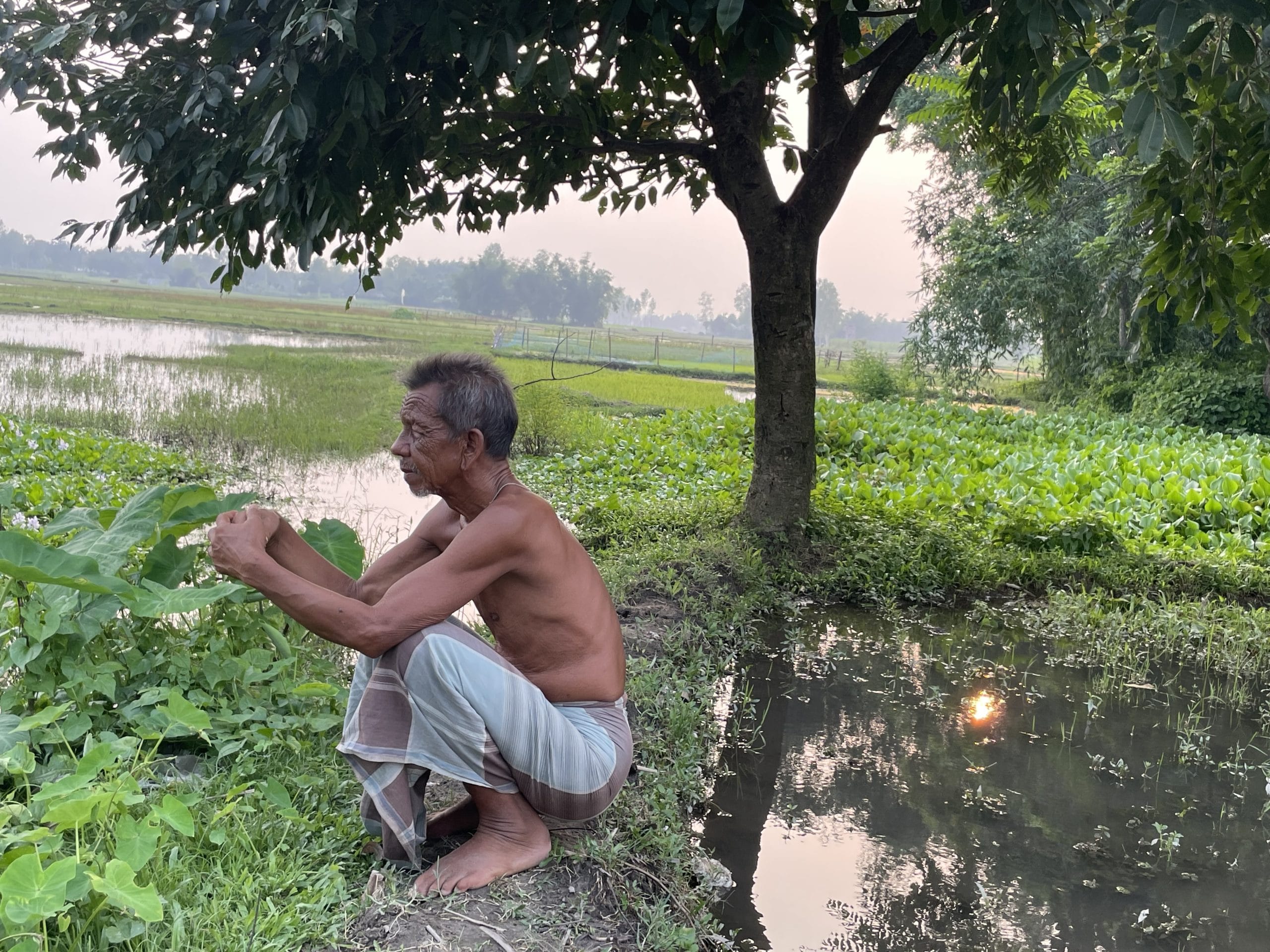
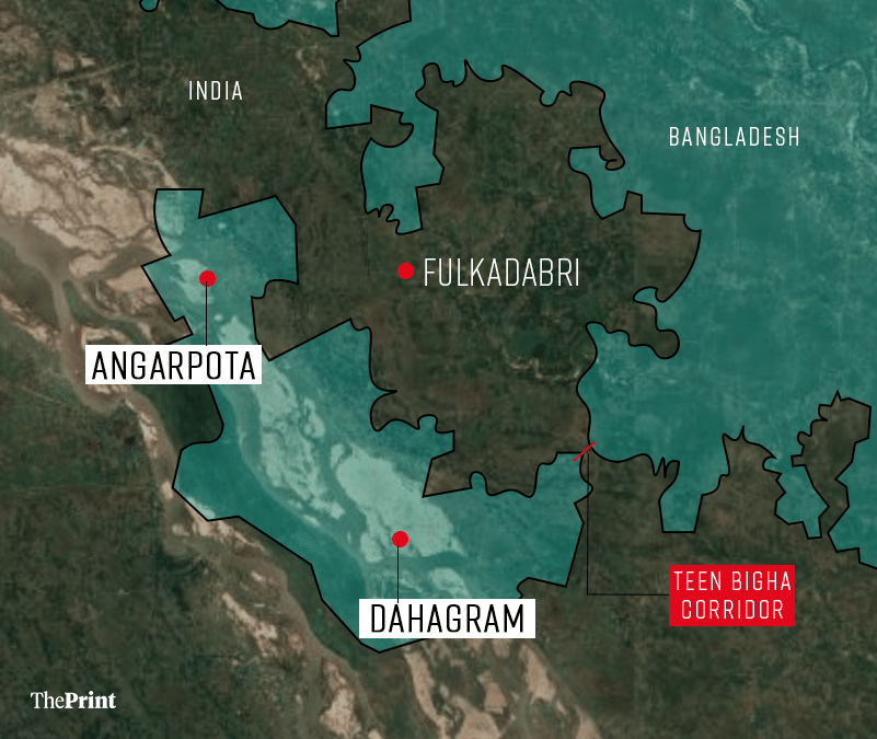
Jalpaiguri/Cooch Behar: Amidst a vast expanse of green marshy fields in Fulkadabri—a village in West Bengal’s northern border district of Cooch Behar—72-year-old Nityanand Barman squats with his legs folded close to his chest. Some parts of the fields belong to him and his family. The rest fall under the Bangladeshi enclave, Dahagram-Angarpota, which is surrounded by India on all sides.
For Barman, who would run across the fields as a child, going around the neighbouring enclave, the need for taar kata (fencing) is yet to make sense.
“Last year, there was a fire in a house in Dahagram-Angarpota. Before their (Bangladeshi) neighbours could reach the spot, our village boys rushed to help,” the farmer said. The enclave is located less than 100 metres away from his house, separated from Fulkadabri with a cattle fence.
Barman says he has never witnessed cross-border violence. “In our village, you can hear crickets, birds and sounds of the crops and trees swaying on windy days, but not those of conflict.”
However, the village’s peace did get interrupted twice over the past few weeks. On 23 May, officials of India’s Border Security Force (BSF) and the Border Guard Bangladesh (BGB) had to undertake a flag meeting after a fiery exchange between the two countries’ border guards over the Indian authorities’ attempt at mapping land for fencing around Dahagram-Angarpota.
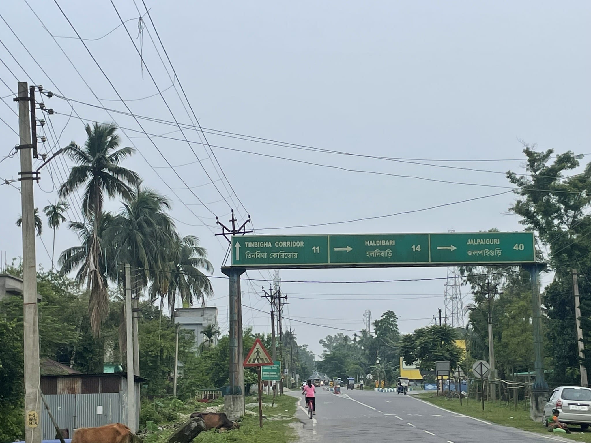
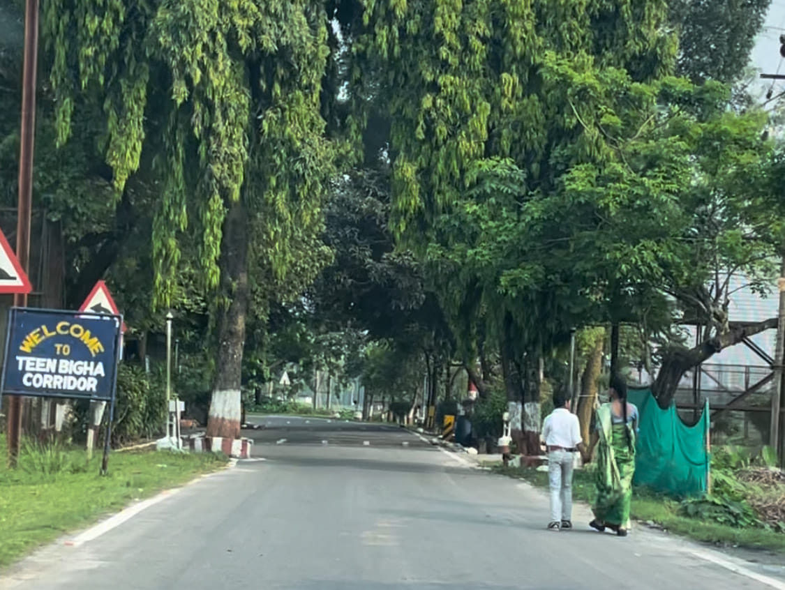
The adjoining Dahagram and Angarpota are connected to Bangladesh mainland by a narrow strip of land called the Teen Bigha Corridor. The corridor, carved out of Cooch Behar to allow the enclave’s residents access to the mainland, was leased to Bangladesh in 1992, years after the historic 1974 Land Boundary Agreement between Indira Gandhi and Mujibur Rehman.
Initially, the Jawaharlal Nehru government had intended on taking Dahagram-Angarpota under Indian territory and handing over South Berubari, a similar enclave in Jalpaiguri district, to the erstwhile East Pakistan, since the former was closer to India and the latter to East Pakistan.
However, residents of the largely Hindu-populated South Berubari moved court against the government’s plan. The Supreme Court ruled in 1965 that the ceding of Indian national territory to a foreign country diminishes India’s sovereignty, and hence, can only be done through constitutional amendment. Eventually, on 16 May 1974, under the Land Boundary Agreement, it was formally decided that India would keep South Berubari and Bangladesh would keep Dahagram-Angarpota.
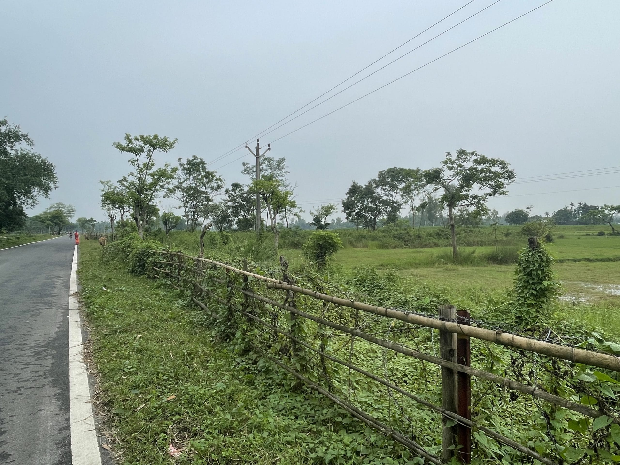
Now, decades later, with the border fencing process gathering pace in West Bengal under the Suvendu Adhikari-led BJP government, Dahagram-Angarpota’s geographical position—protruding into Indian territory—has put Indian authorities in a tricky spot.
“The central government wants to seal the entire India-Bangladesh border, but that would entail building a fence of 32 km around Dahagram-Angarpota,” says a senior BSF officer aware of the matter. The fence would have to be built on three sides of the area, barring the part of the enclave connected to Teen Bigha corridor, he explains.
But the bigger challenge before the BSF is negotiation with the neighbouring country. The land stretch identified for constructing the fence is at a distance of less than 150 yards from the International Border. “To secure this part of the country, we will have to build a fence comparatively closer to the International Border, but this is a serious challenge,” the BSF official tells ThePrint.
The Joint Indo-Bangladesh Guidelines for Border Authorities 1975 prohibits the construction of any defence structure by both countries on either side of the International Border to prevent any kind of escalation.
Face-off with BGB
Raising this very concern, the BGB on 23 May moved towards the 123 Andoran Khorkhoria area in Fulkadabri, following BSF’s attempt to plant flags to mark the upcoming fence. “The BGB officials and some villagers from Dahagram-Angarpota enclaves came rushing towards our village, when they saw BSF officials planting flags on our fields,” Barman recalls.
Tarun Ray, a 42-year-old resident of the village, chimes in. After an initial verbal exchange, there was “pushing and shoving” between the two countries’ border guards.
“Matters got so bad that the BSF took position and posed with their guns. They threatened the BGB that if they entered Indian territory, the BSF wouldn’t shy away from firing.”
According to Barman, the BGB accused the BSF of mapping a stretch 50 yards closer to the zero line within the Indian territory. “When the BSF was planting those white flags, the BGB objected and said that they could not construct a fence there and that the 150-yard rule must be followed.”
The matter escalated further and the BSF allegedly stopped all vehicular traffic on the Kuchlibari-Mekhliganj road that leads to Teen Bigha corridor.
Finally, a flag meeting at the battalion commander-level was organised to discuss the incident and determine further steps, it is learnt. “The BGB had earlier objected when the local authorities were trying to plant a solar panel in the neighbourhood as well, so we are analysing how we can fence the area without obstructing the lives of the Indian villagers in that area, while ensuring cordial relations with BGB,” says a second BSF official.
However, since the altercation, the BGB has intensified patrolling along the border in the area. “They have also asked local villagers of Dahagram and Patgram areas to maintain strict vigil of any movement from our (Indian) side,” the official adds.
Even days before, on 18 May, a similar face-off had taken place. According to Anup Ray, a panchayat member in 123 Andoran Khorkhoria, BSF officials were planting flags to mark a certain stretch, when BGB officials alleged that flags were being planted 10-20 yards from the zero line inside the Indian territory.
Historically too, the mapping for border fencing has been a contentious issue between India and Bangladesh.
In February 2006, the Manmohan Singh government had noted that the Bangladesh Rifles (BDR) was “objecting to construction of border fence within 150 yards of the international border on the plea that the construction of fence is a defensive structure and violates provisions of Joint Indo-Bangladesh Guidelines for Border Authorities 1975”.
S. Regupathy, then Minister of State for Home Affairs, had informed Rajya Sabha in a written reply that the Indian government was trying to convince the Bangladesh government that erection of the border fence does not violate the guidelines, as the fence is “mutually beneficial in curbing trans-border crimes”.
South Berubari
While clashes with the BGB have been creating constraints in the land acquisition process for fencing, the West Bengal government and BSF face another imminent issue. To plant a fence around the DAMP area, Indian authorities also have to acquire land in the South Berubari enclave, where residents are Indian citizens but their land records are either missing or have Bangladesh’s name.
Jagadish Roy Pradhan, chairman of Berubari Protirokha Committee, says that the villagers of Chilahati, Boroshoshi, Naotori-Debottar and Paranigram—under South Berubari—have no objection to handing over their land for fence construction, but the land documents first need to be transferred to bear the name of the Indian State.
“How can the authorities ask for land that has no official document showing it belongs to the Indian State?” he remarks. The Berubari Protirokha Committee has been leading the movement to seek recognition of the enclave as Indian territory and transfer of land records since the 1950s.
Pradhan adds that until the government gives them papers showing that the area has been added to Indian territory, they would not hand over their land. “Our ancestors challenged the Nehru regime’s decision to include South Berubari in East Pakistan then, and we will carry forward the same movement against the present government. We are ready to give our lives for this cause.”
If the authorities take the land without documentation, it would translate into them losing their claim to a rightful compensation, he further says.
The protests on ground have sounded alarm for the BJP-led West Bengal government. Sources say the opposition by South Berubari residents and the troubles with BGB have slowed down the land acquisition process.
“The BSF has been consulting local authorities on how to navigate the fencing of the Dahagram-Angarpota area, but the process on ground is very slow,” says a government official.
Meanwhile, state authorities have decided to seek both documents and possession backed by title deeds to frame land records for South Berubari residents. “The people in those former chitmahals (enclaves) will have to bring out documents, even if they are with kin in Bangladesh. How else will the government know if they own the land or are squatters?” the official adds.
(Edited by Mannat Chugh)
Also Read: The great Bengal border fencing project: In border villages, white flag means a new battle