


New Delhi: It has been over a year since India and Pakistan agreed to a ceasefire following Operation Sindoor. But even as the guns fell silent, India’s neighbour kept sharpening its knives. Over the past 16 months, Pakistan has been stacking up a constellation of spy satellites, specifically designed to continually monitor Indian territory.
Between January 2025 and June 2026, Pakistan launched six Earth-observation satellites, all placed in Sun-synchronous orbits that make them ideal for surveillance.
Collectively, these satellites are mapping Indian territory at least once every two days.
Using Apollo Mapping and SkyFi, ThePrint found that these satellites are carefully positioned to provide Pakistan with continual imagery of Indian territory. These satellites are also monitoring other territories of strategic significance, including Afghanistan, China, Iran and the northern Indian Ocean. This, experts say, could be to keep a close watch on India’s strategic movements beyond its borders, while also tracking the movement of critical assets such as naval vessels and India-bound commercial ships.
But land surveillance is not their only ammunition. These satellites can track military movements in real time and snoop into camouflaged assets with remarkable clarity.
And all of these satellites have come up in a matter of 16 months.
Experts are warning that the sudden revival of the Pakistani space programme, with technical and launch support from China, and the choice of orbit for these satellite deployments, might not be an innocent coincidence.
It is simple logic. A person with walking disabilities would not wake up one day and defeat Usain Bolt. There is much more to this — Former ISRO official
This spells an even more worrying trend against the backdrop of India’s own back-to-back launch failures over the past year, three of which involved strategic satellites.
Sudhir Pillai, former flag officer of the Indian Navy, said that the emergence of this constellation of “civilian” satellites, which just “happen to have military applications on the side”, is no coincidence.
“Between January 2025 and April 2026, SUPARCO placed roughly half a dozen satellites into orbit. That pace represents a structural discontinuity, not an incremental programme update,” Pillai wrote in a blog post.
“Its (the satellites’) orbital architecture, its sensor complement, and above all its institutional provenance tell a different and a more consequential story,” the post added.
After the 1990 launch of Badr-1, Pakistan’s first satellite, it took 11 years for the agency to conduct its next mission. After launches in 2001 and 2002, Pakistan’s next launch came only in 2011. Another followed in 2013, and then two each in 2018 and 2024.
The latest Pakistani launches
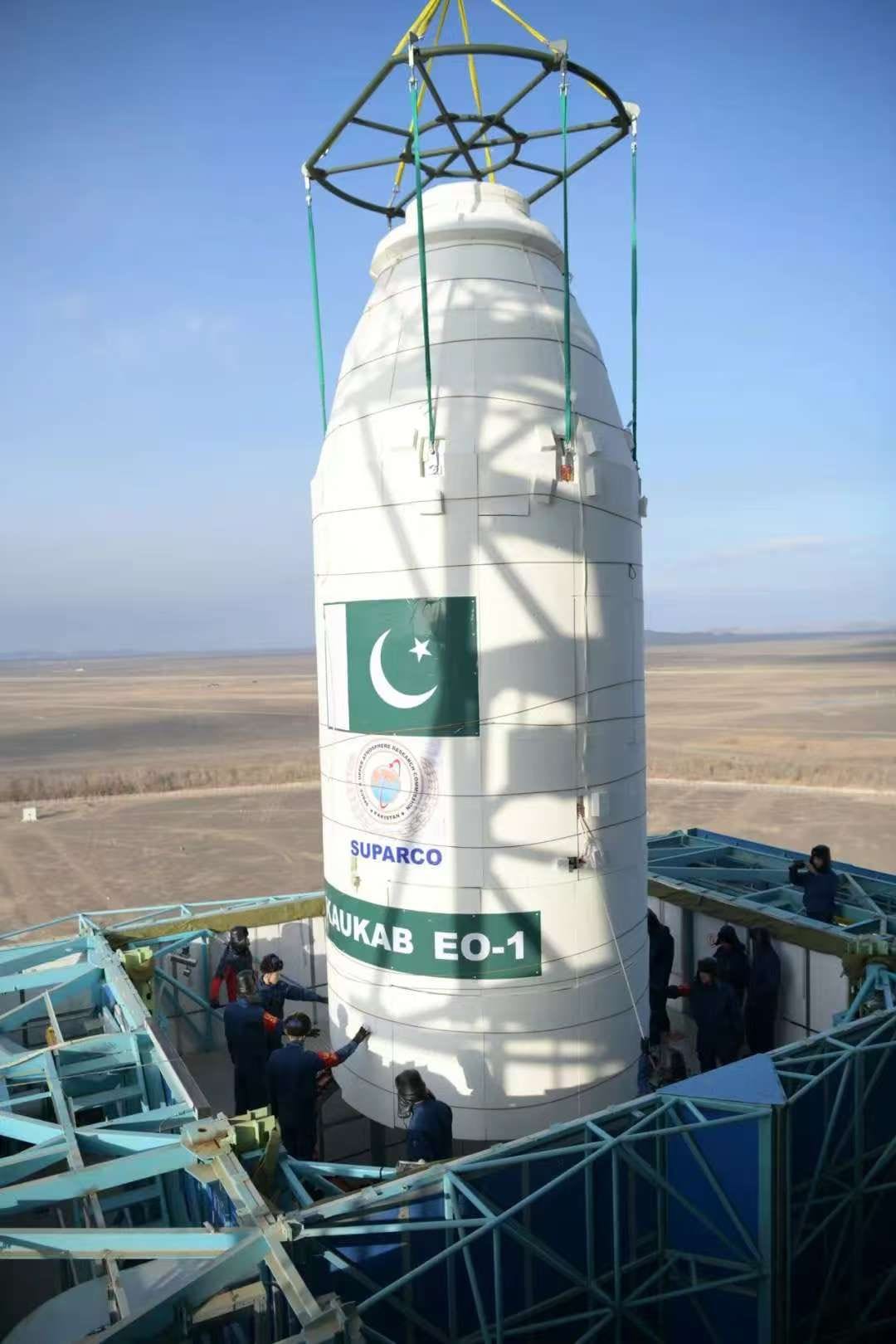
On 14 January last year, the Pakistan space agency, the Space and Upper Atmosphere Research Commission (SUPARCO), launched PAUSAT-1—an Earth observation 16U CubeSat—on board SpaceX’s Falcon9 rocket. The satellite was placed in a Sun-synchronous low-Earth Orbit (SSO), at an altitude of about 513 km and an inclination of 97.4 degrees.
Just three days later, the country launched another Earth-observation satellite, PRSC-EO1 (Pakistan Remote Sensing Satellite-Earth Observation 1). This was launched aboard China’s Long March-2D rocket. Both missions took place three months before the Pahalgam attack and three months ahead of India’s Operation Sindoor.
The back-to-back launches marked the beginning of a revival in Pakistan’s long-dormant space programme.
And Pakistan did not stop there. Since then, it has launched three more missions.
On 31 July last year, it launched the high-resolution Pakistan Remote Sensing Satellite-2 (PRSS-2) in collaboration with China. Then on 19 October, the Pakistani space agency launched HS-1, the country’s first hyperspectral Earth-observation satellite, designed to capture images across hundreds of contiguous narrow wavelengths.
The Chinese satellites monitor Indian territory more than even India does. Each inch of our territory is under surveillance — ISRO official
The imagery produced can identify camouflage, distinguish between different materials and spot structural changes on the ground.
This year, Pakistan launched two more satellite missions—PRSC-EO2 and PRSC-EO3—in February and April. Both missions are designed for high-resolution optical imaging and AI-assisted image processing. These capabilities allow them to monitor military installations and provide continual border surveillance.
Also read: How a Hyderabad pharma firm built a satellite that can spy on foreign assets in space
Why the orbit matters
Apart from the latest technology, these space missions have another thing in common.
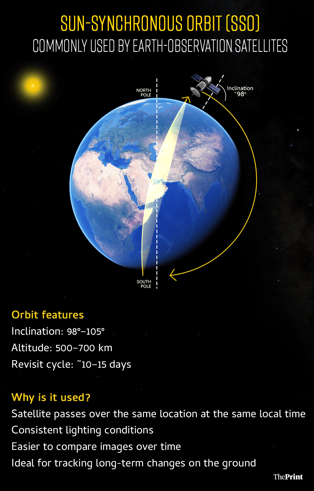
All of Pakistan’s recent satellites have been placed in an orbit that allows them to pass over the same locations at roughly the same time each time. This makes it easier to compare images over time and detect changes on the ground.
A Sun-synchronous orbit is a type of polar orbit in which a satellite remains in sync with the Sun. Because it matches the Earth’s movement around the Sun, the satellite passes over the same location at roughly the same local time every time.
But this is just the tip of the iceberg.
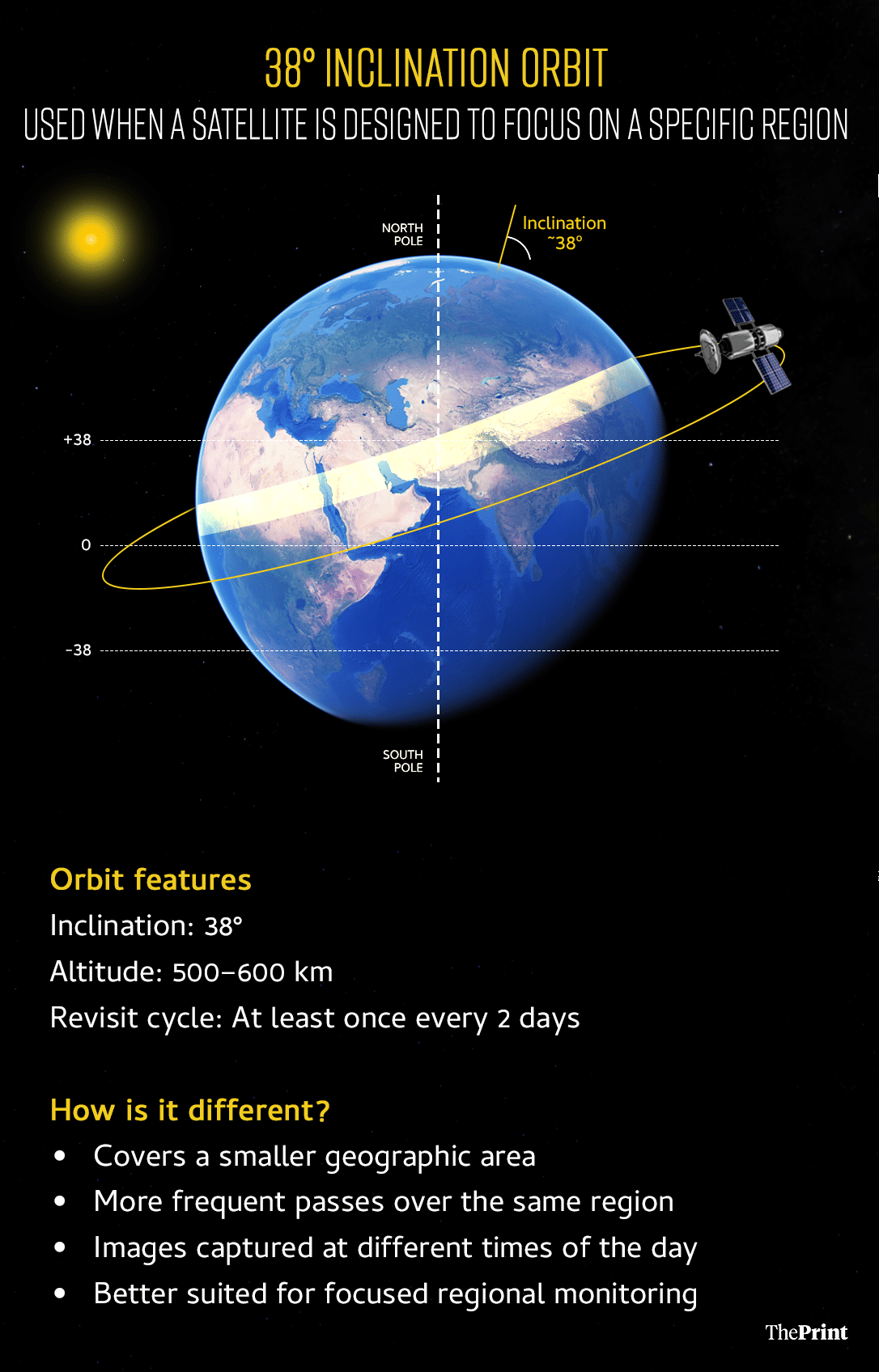
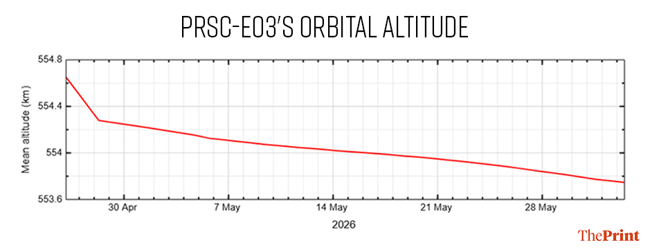
The real intention was recently exposed by COMSPOC, a US-based firm that provides commercial off-the-shelf software for space situational awareness. In a LinkedIn post, the company pointed out that Pakistan’s PRSC-EO3 was displaying an “unusual orbit for an optical satellite”.
Their findings showed that the Pakistani satellite is laser focused on Kashmir.
“Most optical LEO satellites use Sun-synchronous orbits (~97-105° inclination), which provide consistent lighting for imaging. PRSC-EO3 is in a 38° inclined orbit with 334 deg RAAN instead. This sacrifices global coverage and consistent lighting, but increases revisit rates over a specific latitude band: 20-40°N. That’s Pakistan, India, and Kashmir,” the post said.
This essentially means that PRSC-EO3 does not follow the typical Sun-synchronous orbit used by most Earth-observation satellites. Instead, it was placed in a 38-degree inclined orbit with a Right Ascension of Ascending Node (RAAN) of 334 degrees.

RAAN is an orbital parameter used to define the location and orientation of a satellite’s orbital plane.
The lower inclination narrows the satellite’s coverage area but increases the frequency with which it can revisit a specific region. In effect, the satellite sacrifices bigger global coverage in favour of more frequent monitoring of a smaller geographic zone.
According to COMSPOC, the satellite’s ground tracks are roughly between 38 degrees North and 38 degrees South. This range centres around India’s Jammu and Kashmir region and parts of north India, spanning latitudes from roughly 32°N to 37°N.
That means the satellite can pass over the region more frequently—potentially multiple times a day—allowing Pakistan to build a far denser stream of imagery than would be possible through a conventional Sun-synchronous orbit.
“Five remote sensing satellites in 16 months. All launched by China. All with orbits favouring South Asian coverage. The stated missions are civilian. The orbital architecture appears consistent with a multi-modal ISR constellation.”
These satellites can track movements in real time and also support precision-guided strikes.
Also read: Is India’s ambitious Mission Drishti ‘tumbling’ in orbit? Trackers raise alarm
Civilian satellites, military eyes
Experts said that these satellites might have been pitched innocently for agriculture, disaster management and telecommunication purposes, but their military uses cannot be overlooked.
Ashwin Prasad Rao, space strategy expert and staff research analyst at the Advanced Military Technologies and Outer Space Programme at the Takshashila Institution, told ThePrint that surveillance of India can come from three sources—dedicated military satellites, dual-use satellites that provide Earth observation, and commercial satellite services (such as Vantor, formerly Maxar).
“Effectively, most commercial Earth-observation imagery can be purchased or tasked by paying customers, including foreign governments, to image Indian sites,” Rao said. He, however, caveated that in today’s age, virtually every Earth-observation satellite designated for civilian use can also serve military purposes, and vice versa.
He added that the Sun-synchronous orbit is not an unusual choice for Earth-observation satellites.
Effectively, most commercial Earth-observation imagery can be purchased or tasked by paying customers, including foreign governments, to image Indian sites —
Ashwin Prasad Rao, space strategy expert
Rao pointed to the recent conflict in West Asia to illustrate how commercial imagery is neither neutral nor guaranteed.
On one side, US firm Planet Labs withheld imagery of Iran and the wider conflict zone in April 2026 after a request from the US government, switching to case-by-case “managed access”.
The episode served as a reminder that commercial providers can restrict imagery during a conflict at the behest of their home governments.
On the other side, the Financial Times reported, citing leaked Iranian documents, that Iran’s Islamic Revolutionary Guard Corps (IRGC) had acquired and tasked a Chinese-built satellite to monitor US military bases ahead of its strikes.
China denied the claim.
Rao said the denial itself is revealing: Iran reportedly owned and tasked the satellite rather than relying on China to operate it, allowing Beijing to plausibly claim that it had no role in directing where the satellite looked.
“That’s why they sell the capability instead of the service. You give someone the eyes in the sky and can still claim you had no hand in what they did with them,” he said. “In today’s world, you cannot do much about it. What India needs to do is understand that our territories are under constant surveillance and increase our own eyes in the sky.”
China-Pakistan partnership
Space and defence experts say that Pakistan’s space ambitions should not be viewed in isolation.
A former official of the Indian Space Research Organisation (ISRO), who has been tracking the Chinese and Pakistani space programmes, said that over the past few years the space efforts of both countries have increasingly complemented one another.
Their programmes, he said, are backed by active information sharing.
“The Chinese satellites monitor Indian territory more than even India does. Each inch of our territory is under surveillance,” the official said.
The official also said that open-source material has pointed to a China-Pakistan partnership during Operation Sindoor.
Though not confirmed, Pakistan is known to have relied on Chinese satellite constellations, including the Yaogan and Gaofan series.
While China’s space programme largely operates in secrecy, some of its satellites possess among the most advanced Earth-observation capabilities in the world.
Its Yaogan satellite series, which literally translates to “remote sensing”, is a space-based reconnaissance system with surveillance coverage over at least one-third of the Earth’s surface.
“Its resolution is enough to detect and likely classify large ships. These satellites provide high-resolution imagery and all-weather, day-and-night surveillance capabilities, even through cloud cover. One of the main objectives of the ‘Yaogan’ series of satellites is ocean surveillance, and the satellites can detect ships and early warning aircraft,” a 2025 report analysing China’s space-based surveillance capabilities by the Manohar Parrikar Institute for Defence Studies and Analyses (MP-IDSA) said.
The Gaofan and Ziyuan series can also provide high-definition 3D imagery and multispectral data.
A March 17 story published in Swarajya magazine, titled ‘China Has Built A Triad Of Satellites, Towers And Fibre To Never Lose Its Way In War. India Doesn’t Have One’, also highlighted the sharing network between China and Pakistan.
“China has also extended this advantage to its allies. In 2018, it gave Pakistan access to BeiDou’s military-grade navigation data, enabling far more precise targeting for missiles, aircraft and naval platforms,” the story by Prakhar Gupta noted. “Indian officials say Pakistan has since shifted entirely to BeiDou for both military and civilian use, eliminating its dependence on GPS.”
The unusual pace of Pakistan’s space programme
The sudden revival of Pakistan’s space programme last year, and the frequency of launches since then, has also raised suspicion.
Since 1961, when Pakistan’s space agency SUPARCO was established, it has conducted a total of 15 satellite launches — six of those launches have taken place in the last 16 months alone.
Before 2025, the programme had progressed at a glacial pace.
After the 1990 launch of Badr-1, Pakistan’s first satellite, it took 11 years for the agency to conduct its next mission. After launches in 2001 and 2002, Pakistan’s next launch came only in 2011. Another followed in 2013, and then two each in 2018 and 2024.
Experts warn that it is not just the number of recent launches (six), but also the speed at which they have occurred, that points to the possibility of external support.
Pakistan launched PAUSAT-1 on 14 January 2025. Just three days later, it launched PRSC-EO1. Within just six months, the Pakistani space agency launched PRSS-2.
There was then only a four-month gap between HS-1 and PRSC-EO2, followed by another two-month wait before PRSC-EO3.
For a programme that had historically moved at a crawl, these successive launches represent a dramatic shift.
This pace compares favourably with several far more mature space programmes. The European Space Agency (ESA), for example, averages six to seven launches a year, while India has maintained an average of around six orbital launches annually.
“It is simple logic. A person with walking disabilities would not wake up one day and defeat Usain Bolt. There is much more to this,” the former ISRO official said.
India’s lost focus
What is particularly worrying amid these developments is India’s own recent setbacks.
Between 2025 and 2026, India suffered losses in three strategic satellite missions. In January this year, ISRO failed to place its strategic satellite EOS-N1, also known as ‘Anvesha’, in its intended orbit.
EOS-N1 was a 150-kg Earth observation satellite built by the Defence Research and Development Organisation (DRDO). Designed as a hyperspectral imaging satellite, it was equipped to identify materials beneath multiple layers, detect camouflaged weapons and tanks, and monitor illegal movements around national borders.
It is precisely these capabilities, details that are often missed by the human eye and even by conventional optical-imaging satellites, that have made Pakistan’s recent hyperspectral launches noteworthy.
Experts have pointed out that ISRO may have misdirected its focus toward high-profile science missions such as Chandrayaan and Gaganyaan rather than more urgent strategic requirements in space.
Before this, in May last year, India’s EOS-09 satellite (RISAT-1B) also failed to reach its intended orbit.
EOS-09, another Earth-observation satellite weighing around 1,710 kg, was equipped with a C-band synthetic aperture radar (SAR). It was designed to provide high-resolution imaging even under adverse weather conditions, including heavy rain and cloud cover.
India’s ambitious navigation satellite programme, NavIC, also suffered a setback in January 2025 when the NVS-02 mission failed.
Experts have pointed out that ISRO may have misdirected its focus toward high-profile science missions such as Chandrayaan and Gaganyaan rather than more urgent strategic requirements in space.
The ISRO official who spoke to ThePrint said this is an era of rapid advances in space capabilities and there is nothing illegal about building a surveillance support system in orbit.
However, he argued, India needs to keep pace with its neighbours if it hopes to maintain an upper hand in a war situation.
“Information is everything in a conflict situation. We saw that during Operation Sindoor and we are seeing that in the US-Iran war too. The only way to counter surveillance is through surveillance,” the official said.
(Edited by Prashant Dixit)
They already had the chinese and turkeye satellites.
I think the word continuous and continuously should be replaced with continual and continually respectively.