



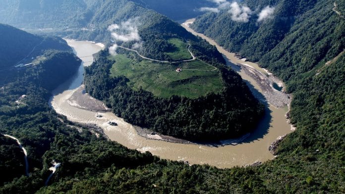
New Delhi: Tibet’s Yarlung Tsangpo River, which becomes the Siang and eventually the Brahmaputra in India, could see rising runoff and heightened flood risks in the coming decades, according to a new study by Chinese researchers. The findings come as China is building what is set to become the world’s largest hydropower project on the river’s lower reaches.
Published in the China Science Bulletin on 8 October, the study reconstructed the river’s history from 1325 to 2020 using tree-ring width technologies. The researchers combined this record with weather data from the region to project how the river could respond to future climate scenarios.
The study warns that climate-driven warming is fundamentally altering the river basin’s hydrology. This creates severe design, safety, and geopolitical complications for China’s planned $168 billion, 60,000-megawatt mega-dam in Tibet’s Medog—set to be three times the size of the Three Gorges Dam.
The construction of the project began in July 2025, raising geopolitical and environmental tensions between China and downstream nations over ecological damage and Beijing’s control over a river that sustains millions of people.
The study does not claim that China’s engineering or dam architecture will trigger floods down the river line into India. However, it emphasises the immense operational challenge of managing a mega-infrastructure project on a river experiencing volatile, climate-driven flow changes.
Here is what the research found, and what it means for China and India:
According to the study, climate change scenarios project a significant increase in the river’s runoff, heightening the frequency of severe high-flow events. Such events can increase pressure on river channels and make flood management more difficult.
Runoff refers to water flowing over land or through the ground into rivers. It is influenced by rainfall, snowmelt, and glacier melt, among other factors.
Nonetheless, higher runoff does not automatically mean more floods. The risk depends on how much water enters the river, how quickly it arrives, the river’s capacity to carry it, and whether heavy rainfall coincides with other extreme events.
The study also does not pinpoint exactly when a specific flood will hit. Instead, it maps out the big picture of how the river’s water patterns are shifting over time and flags the long-term dangers heading our way as the climate changes.
What is the significance of Yarlung Tsangpo River?
The Yarlung Tsangpo River originates at the Angsi Glacier in southwestern Tibet, near Mount Kailash in China. It flows roughly west-to-east across the southern Tibetan Plateau for more than 1,600 kilometres. Upon reaching the eastern edge of the Himalayas near the Namcha Barwa peak, the river takes a U-turn—the “Great Bend”. It plummets rapidly through the Yarlung Tsangpo Grand Canyon—the world’s deepest canyon—and cuts southward through the mountains.
The river enters India’s northeast region in the state of Arunachal Pradesh, where it adopts the localised name Siang. After tumbling down the mountains, it reaches the plains of the Assam Valley. Near the town of Sadiya, the Siang merges with two major Himalayan tributaries—the Dibang and Lohit Rivers. From this confluence onward, the river swells in width and takes on the name Brahmaputra.
The river continues westward across Assam before another sharp turn to cross into Bangladesh. In Bangladesh, it is known as the Jamuna River, which eventually merges with the Padma (Ganges) before merging into the Bay of Bengal.
In South Asia, the river functions as an ecological lifeline and a seasonal challenge, dictating the socioeconomic structure of Northeast India and Bangladesh.
The river also runs down through the steep, geologically volatile Himalayan terrain where seismic activity and frequent landslides create immense engineering hazards for large-scale water infrastructure.
Hence, any significant disruption to the river’s flow—whether driven by climate change or massive engineering projects—will trigger a geopolitical and ecological crisis.
What is China building on the river?
China’s massive installation will feature five cascading hydropower stations designed to exploit the steep Himalayan drop to generate clean energy. The project is located in the world’s deepest canyon, the “Great Bend”.
The project capitalises on the river’s dramatic drop through the Himalayan terrain to generate immense power. The facility will reportedly produce around 300 billion kilowatt-hours of clean electricity every year. While initial testing and grid connections are targeted for 2030, the entire mega-complex is scheduled to be operational by 2033.
While Beijing highlights the mega-dam as a leap toward clean energy, its unprecedented scale has triggered global anxiety.
“Once completed, the super-dam will dwarf the Three Gorges Dam on the Yangtze, currently the world’s largest. It is set to drastically alter water flows into India and Bangladesh, destabilise the region’s ecological balance, and significantly boost China’s geopolitical leverage over its southern neighbour and rival India,” geostrategist Brahma Chellaney posted on X.
India’s main anxieties stem from a lack of transparency regarding the project’s design and operations, particularly how future water storage and management choices might disrupt transboundary river flows.
“The Chinese side has been urged to ensure that the interests of downstream states of the Brahmaputra are not harmed by activities in upstream areas,” Indian foreign ministry spokesperson Randhir Jaiswal had said earlier. “We will continue to monitor and take necessary measures to protect our interests.”
Also read: Peddi is a shame Janhvi Kapoor says she will ‘always carry’
Why is India concerned?
New Delhi views Beijing’s upstream infrastructure through two lenses. First, the lack of transparency gives China upper-riparian leverage near the border. Second, trapping silt and altering natural water cycles threaten the fragile biodiversity of Northeast India and the Brahmaputra lowlands.
China’s project has also pushed the Indian government to accelerate plans for the Siang Upper Multipurpose Project (SUMP) in Arunachal Pradesh. It is designed as a strategic safeguard to regulate river flows and act as a water-storage buffer against sudden flash floods or artificial water shortages caused by China’s project.
However, they also trigger intense resistance over ecological devastation, forced displacement, and the destruction of indigenous communities.
For India, the challenge is to adapt to shifting river conditions without allowing every development to trigger immediate panic.
(Edited by Ratan Priya)