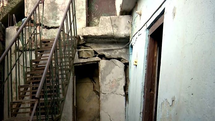
New Delhi: Land subsidence in Uttarakhand’s Joshimath town is due to a combination of factors including improper drainage systems, construction on unstable land mass without adequate checks, and deforestation, according to sources in the Modi government.
Panic consumed the town after sinking landmass left huge cracks in houses and roads, forcing hundreds to be evacuated. All nine municipal wards of the town have been declared “disaster affected” and “unsafe for living” under the Disaster Management Act.
The Union government has appointed teams of experts from the National Disaster Management Authority, IIT Roorkee, the Geological Survey of India, and the Wadia Institute of Himalayan Geology, among others, to inspect the area.
According to a source from one of the teams, the experts have called for a “detailed geotechnical and geophysical investigation” of the area to determine its carrying capacity. Other mitigation measures include conducting building vulnerability assessments, followed by a “repair and retrofitting strategy for the partially damaged houses”. Retrofitting involves making structures more resistant to seismic activity.
Data with the Chamoli district administration shows that at least 603 houses in Joshimath were found to have cracks. Relief efforts are likely to continue over the next few days.
Widening of the all-weather Char Dham road between Helang and Marwari has been stopped until further orders, as has construction work on the NTPC’s Tapovan Vishnugad Hydro Project and the Joshimath-Auli ropeway.
Experts say land subsidence in the area has been a long time coming because of anthropological pressures over an ecologically fragile area.
“There are many factors that have led to this. First, it is an old landslide zone which was pointed out in a report from 1976. Then, during the construction of a tunnel for the Tapovan Vishnugad Hydropower Plant in 2009, an aquifer was punctured, which led to considerable groundwater loss. We don’t know if that aquifer was ever recharged,” said Harsh Vats, a geologist and PhD candidate at the Indian Institute of Remote Sensing-Dehradun (IIRS-D).
“A third reason is major soil erosion because of the changing course of the Alaknanda river,” he added.
IIRS-D is conducting a “deformation study” using satellite imagery to determine the rate of subsidence over the last few years and whether it has accelerated in recent times. The study’s results are likely to be out next week, Vats said.
Also read: Green hydrogen in SIGHT, India has taken a leap. Now ensure it doesn’t end up being hot air
Warnings long ignored
Local residents and experts have long warned of land subsidence in the area. In 1976, a report by a Union government-appointed panel, led by bureaucrat M.C. Mishra, found that Joshimath lay over “a deposit of sand and stone — it is not the main rock — hence it was not suitable for a township”.
The report further warned against the removal and blasting of boulders along the hillside, that major construction activities should be restricted, and that water seepage from the soil should be properly removed through drainage channels to avoid landslides.
In 2010, now executive director of the Uttarakhand State Disaster Management Authority Piyoosh Rautela co-authored an article in the peer-reviewed journal Current Science that said the aquifer puncture for the Tapovan Vishnugad Hydropower Plant tunnel reportedly led to a loss of 700-800 litres of water per second, and up to 70 million litres of water per day.
“This sudden and large-scale dewatering of the strata has the potential to initiate ground subsidence in the region, thereby augmenting the problem of masses living in the area. Reduced ground moisture regime would result in depleted biomass availability and crop produce that would adversely affect the life support strategy of the masses. It would also impact floral and faunal diversity,” read the article titled ‘Disaster looms large over Joshimath’.
According to a report by IndiaSpend, villagers in Uttarakhand reported cracks developing in their homes even after the 2013 flash floods.
In 2021, a deadly ice-rock avalanche in the Chamoli district killed over 200 people and destroyed part of the Tapovan Vishnugad Hydropower Plant, possibly exacerbating the subsidence problem.
“The disaster led to the reactivation of multiple stabilised old landslide deposits between Reni and Marwari. In addition to this, approximately two-thirds of the landslides in the region (Alaknanda valley) were accelerated by anthropogenic intervention mostly by the removal of slope toes at road cuts,” read a paper submitted to the state government in May last year. The research was led by Sarswati Prakash Sati, a geologist with the Uttarakhand University of Horticulture and Forestry.
(Edited by Smriti Sinha)
Also read: Why Indian scientists are critiquing IPCC report — unfair burden on developing countries


