

New Delhi: Ever since China cut funding for the China-Pakistan Economic Corridor over corruption allegations, work on the trillion-dollar Belt and Road Initiative, President Xi Jinping’s dream project, has been progressing slowly.
India has also raised objections to the project a number of times, since the corridor passes through Pakistan-occupied Kashmir.
But now, satellite imagery shows that the CPEC has a weak link — the road through Gojal Valley in the Gilgit-Baltistan region of the Karakoram mountains. ThePrint takes a closer look at why it could be the Achilles Heel of the CPEC.
Massive landslide
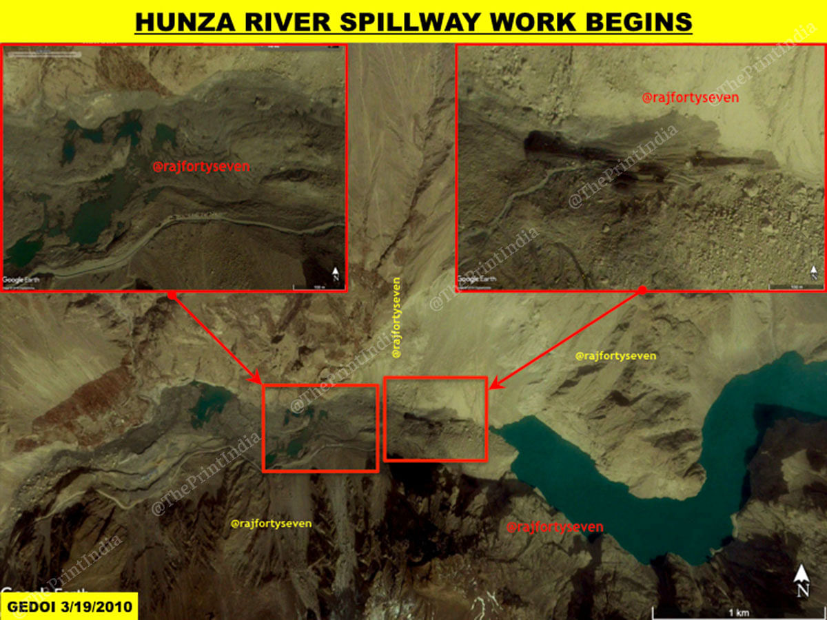
On 4 January 2010, a massive landslide occurred near Attabad, blocking the Hunza river and the Karakoram Highway (KKH). The enormity of the landslide was understood only by March 2010, when almost 30 kilometres of the KKH went under water and many villages upstream were flooded.
The 142 Road Maintenance Battalion (RMB) under the Frontier Works Organisation (FWO) was pressed into service, supposedly with the help of Chinese engineers, to create a spillway through 2.5 billion cubic feet of debris damming the Hunza river.
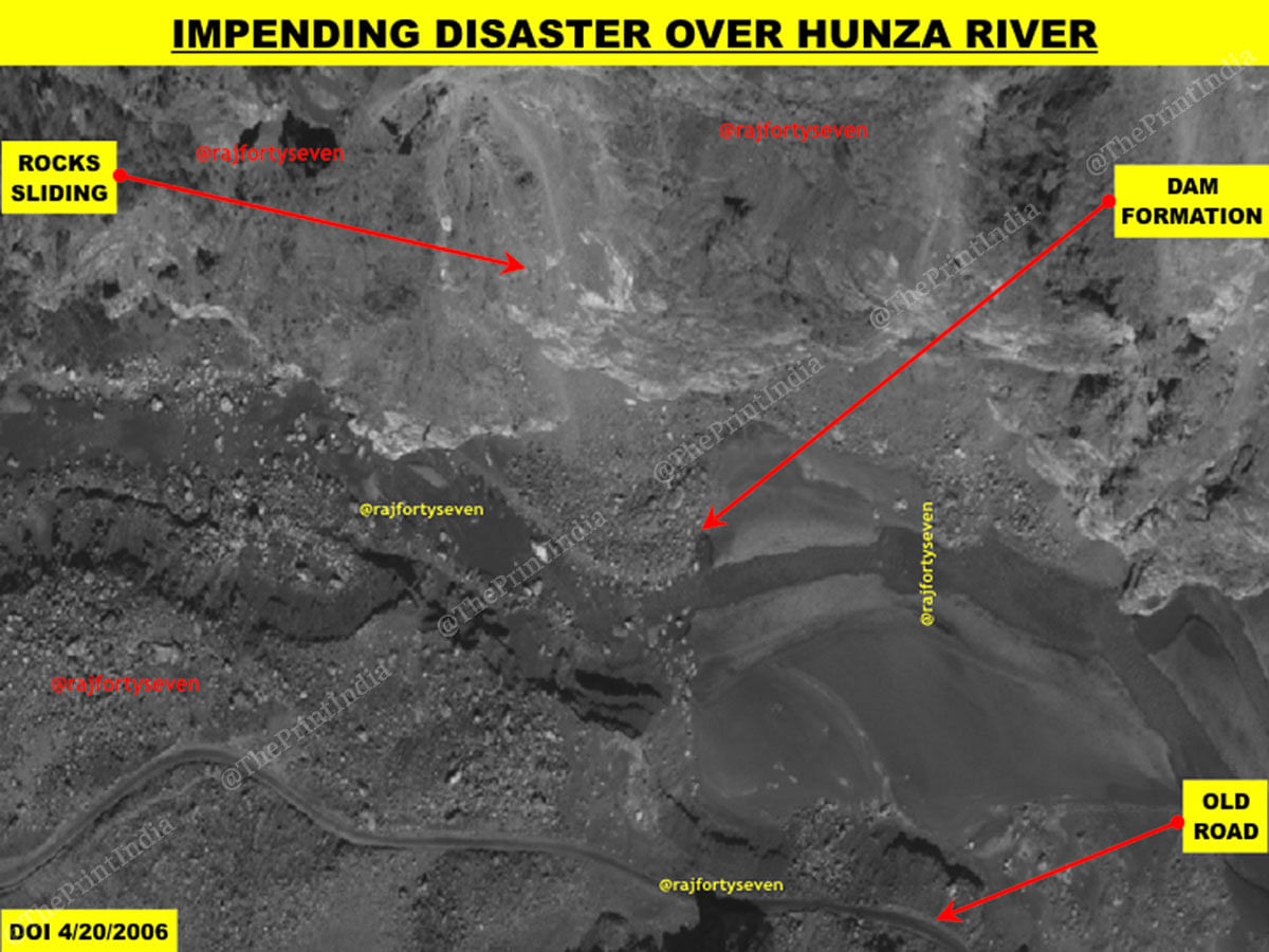
There were indications about an impending disaster on satellite imagery as old as 2006, since the landslide at Attabad became active. The image clearly shows a dam being formed across the river with boulders from the landslide, in an almost man-made fashion.
The difficult job of clearing the landslide started in March 2010, but hardly made a dent in the 130m-200m high natural dam.
The people of Gojal got frustrated due to apathy displayed by the government of Pakistan, and started working on the spillway, losing precious lives in the process.
The damming of the Hunza river waters created a huge lake, stretching up to 30 km behind the landslide zone, beyond the town of Pasu. Residents then started using the lake to travel by boat. Today, the Hunza Lake or Attabad Lake has stabilised at 9 km from the spillway near Attabad.
The massive efforts to open the road link were unsuccessful, so Pakistan sought the help of China and the World Bank.
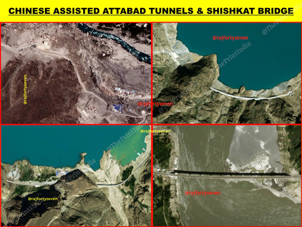
Five tunnels covering a total of approximately 8 km were dug, and in 2016, the KKH was finally reopened for through traffic after six-and-a-half years. The first large convoy sent on this road was a car rally from Beijing to Muscat, Oman.
The old Shishkat bridge, which had been washed away after remaining under water for four years, and a new bridge, whose piers had been completed before 2010, was finally constructed.
Status in different seasons
Although the KKH has been open for nearly three years now, traffic has to be restrained due to the tunnels en route being small in size, and not being able to take sustained two-way traffic.
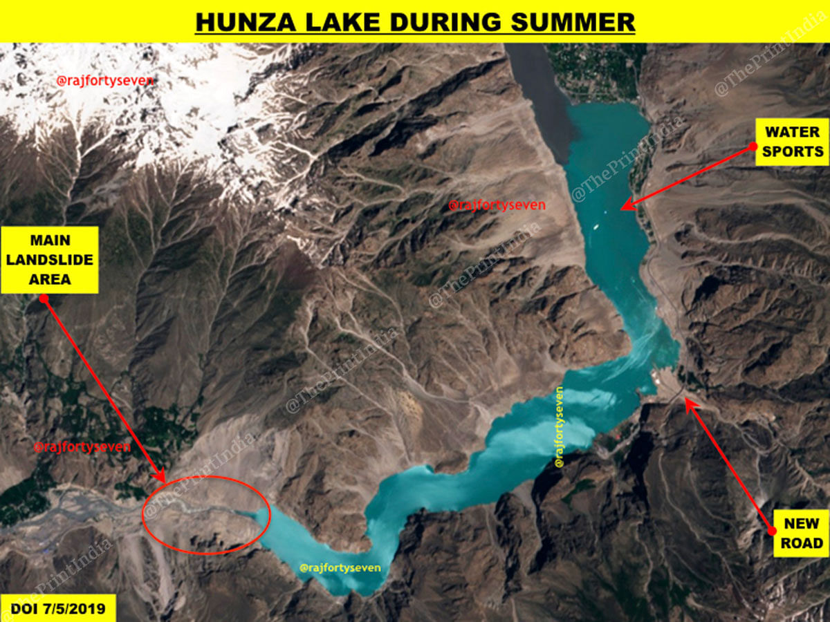
In summer, images from the last couple of months show a turquoise-coloured lake with some water sports taking place on it. The road is open for traffic, indicated by vehicles observed on the road.
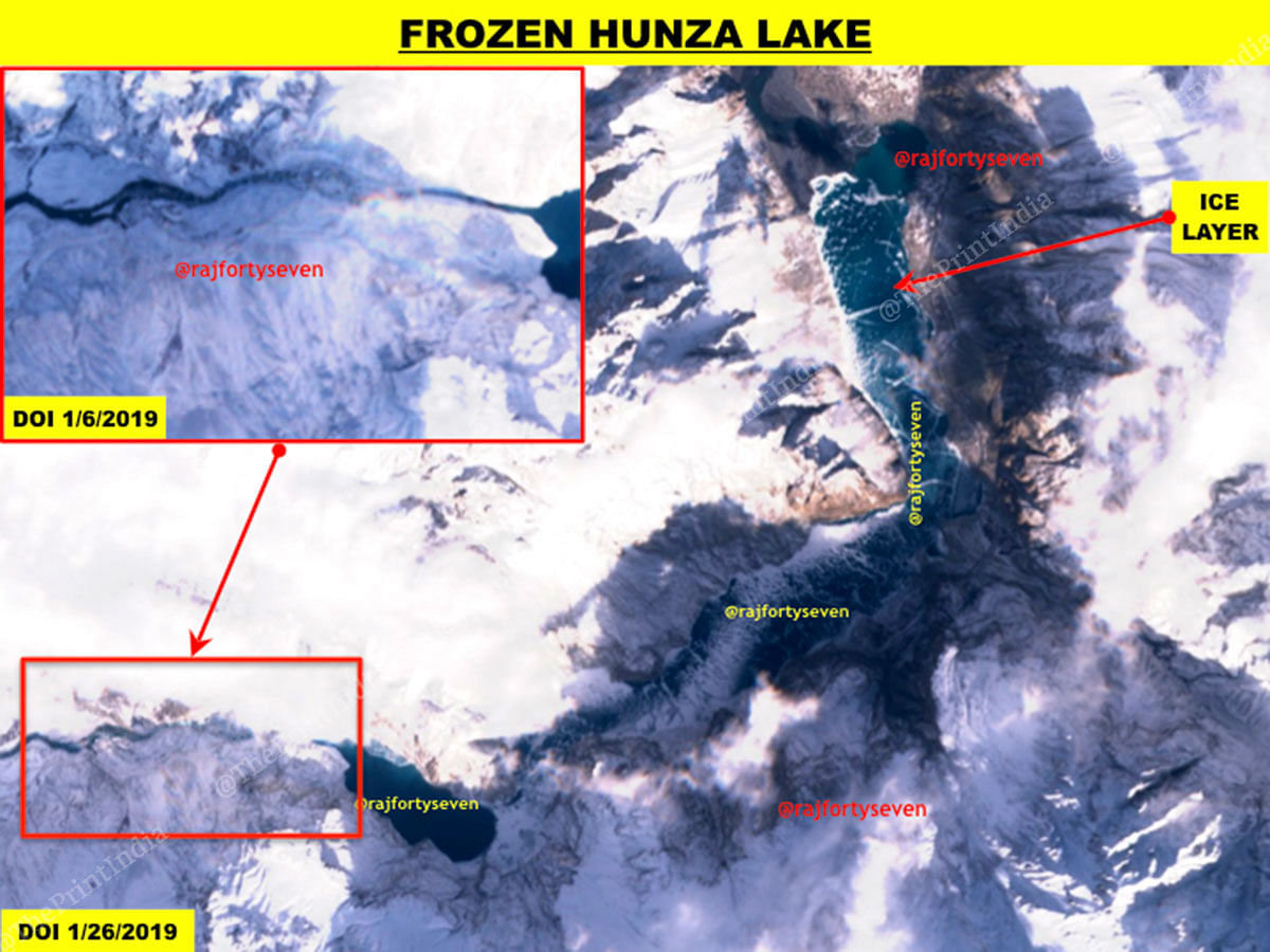
However, it is in the winter months, between October and March, that the road becomes a weak link for the CPEC, because it is blocked due to heavy snowfall and remains closed for traffic.
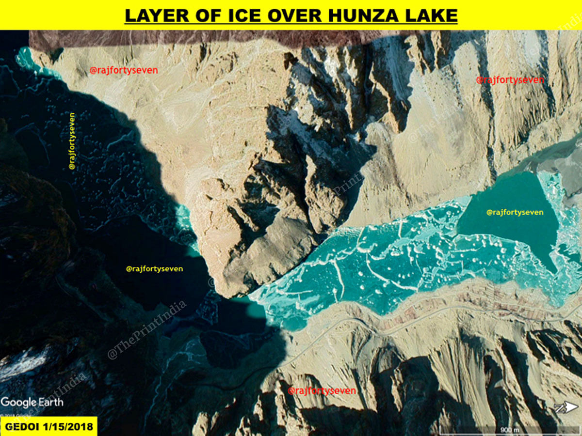
On clear days, satellite images display a frozen lake with an ice layer on the top. Those wishing to travel in and out of Gojal have to trek about 8-10 km on the lake with their loads.
The Chinese have not yet decided to invest in this area, possibly due to a combination of reasons, including pressure from India and other countries. But this weakness in the CPEC could also have factored into its hesitation.
Also read: The Chinese resort in Cambodia that can overnight be turned into a naval base
The CPEC is solely for the purpose of having a Chinese Army on the Pakistani soil and check India. Already as per the reports, the Chinese are already having seven thousand troops in Pakistan on the pretext of guarding the economic assets of the Chinese from being attacked by the Balochi insurgents. Pakistan has already become a Chinese colony of like North Korea. Pakistan is already started bleeding and will be further ruined under the Chinese debt trap.
Just like most Indians,you prefer living in fools paradise. The CPEC project involves a massive investment in Pakistan’s economic infrastructure. It’s going well as planned. For example, the sever power shortage of few years ago is now non-existent in Pakistan. More projects are at different stages of successful implementation. More are on the way. Chinese firms are now planning to shift many industrial units into Pakistan and that will not only bring jobs into Pakistan but advanced technology too. I can understand the frustration in Indians as they see our gain as their loss. Good luck guys. You failed before and you’ll fail future too.
Absolutely, Gulzar. All know Pakistan is doing so well economically. Disregard the Indians
This is a physical drawbacks of over enthusiastic Chinese engineers. Pakistanis were simply eager to get China involved in Kashmir.
Other drawbacks include, 14,000 feet passes connecting China with Pakistan which are vulnerable to weather conditions. The Chinese manufacturing on East Coast is 4,000 km away. That distance plus the high mountain passes, above described hazards, insurgency in Bulochistan and 2,000 km distance in Pakistan to sea, makes it totally uneconomical. Goods from China’s east coast can more economically come via Indian Ocean and can get to Africa and other Indian Ocean littoral states by sea, cheaper and faster than the unreliable mountain and desert road. Hence this road is unwanted and not needed. It is dream of politicians in China as well as Pakistan. Chinese wished to place their surplus export cash in useless projects like this. In fact, Pakistan got trapped into high interest, high cost project just to get China into India – Pakistan affairs.