


Tharparkar coal mining and power projects are barely 10 km from Indian border, have potential to cause environmental damage.
95 sq km area in the Rann of Kutch that has been virtually leased to China’s state-owned enterprises to mine coal can pose environmental and security threats to India.
The Tharparkar coal mining and power project, being set up by China, is 40 km from the Indian border in the Rann of Kutch while the Phase II project site is barely 10 km from the border.
The mining efforts may not take much time to be converted into any military misadventure by China or Pakistan. India could find it difficult to figure out how much tunnelling has been done underground at a depth of 125 m across the border.
An analysis of satellite images (dated 28 October) capturing the entire Tharparkar area reveals that 70 per cent of the project work is complete.
The China Pakistan Economic Corridor (CPEC) has changed many things in Pakistan, including government policies. And the Tharparkar coal mining project seems to be a part of this grand plan.
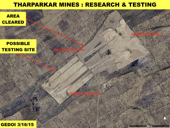
Pakistan has had no expertise at all in open pit coal mining until recently. A Chinese firm, Sinocoal International Engineering Research and Design Institute, came to its rescue. The ground research and testing had probably begun in 2015.
Thar coal is lignite (brown coal), a low quality coal used for electricity generation across the world.
Phase I of the project
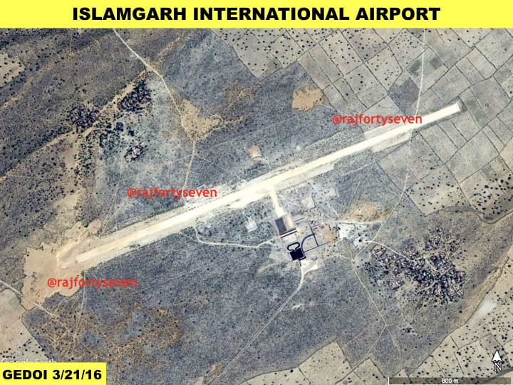
The main mine of Phase I of the project is located 25 km east/northeast of Islamgarh village of Tharparkar district of Sindh province. The Phase II is approximately 35 km southeast of Islamgarh.
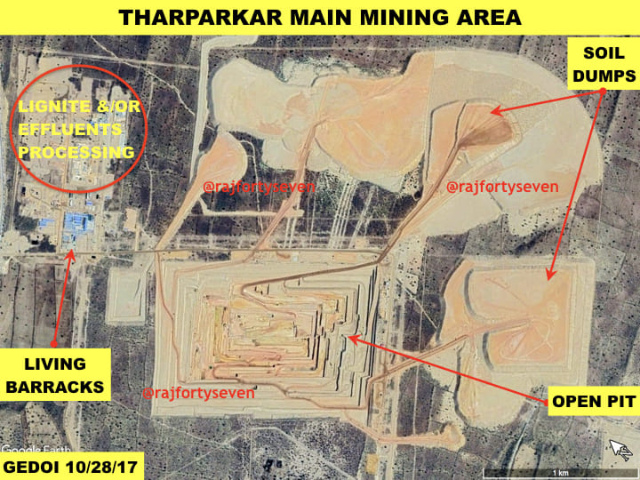
The main mine is approximately 1,400 m x 1,100 m at the top, 380 m X 130 m at the bottom and has a depth of 80-90 m.
The excavated soil is being distributed in piles to the east of the mine. There are seven groundwater collection tanks. Studies on open pit mines from across the globe show that there could be a danger of collapse after 100 m depth.
Power plant
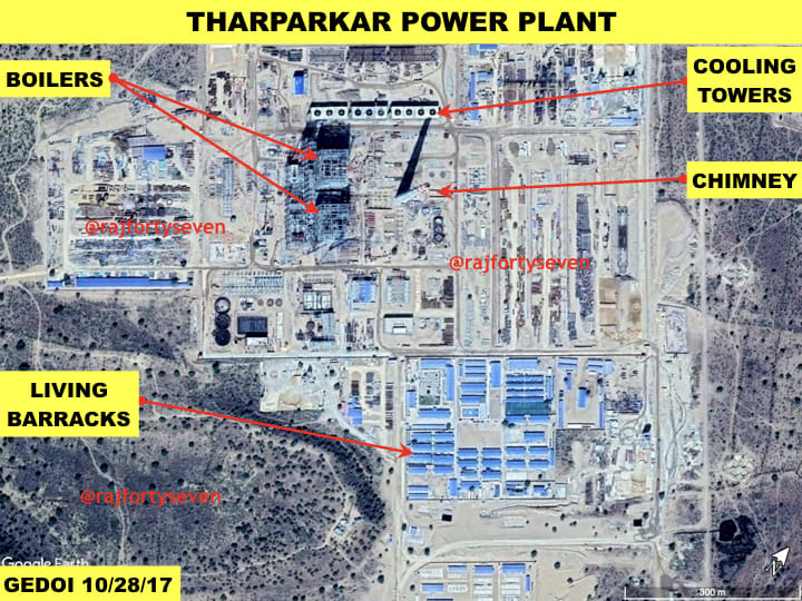
The China Machinery Engineering Corp (CMEC) is probably constructing the coal power plant, located 1.5 km north of the main mine, in a joint venture with Engro Powergen Thar (Private) Limited.
The CMEC has also agreed to further supply two 3,30 MW boilers to Engro for the Thar Phase II power plant.
The satellite images dated 28 October 2017 show that the power plant is 70 per cent complete with three crushers, two boilers and 10 cooling fans. A large chimney is also observed on the premises.
The round tanks, as seen in the images, will be used to manage exhaust gases and effluents from the power plant.
Administrative area
There is an administrative area 500 m north of the main mine. It has 20 living barracks, four to six office barracks and four motor transport garages. There is a dumping area as well. Some constructions near this administrative area suggest that it will either be an effluent disposal system and/or lignite processing system.
Some administrative and living barracks have been constructed near the power plant as well. These are possibly occupied by Chinese personnel.
There is no special housing project for Pakistani workers or people displaced due to project work.
Roads and airport
New roads are being constructed to all the 13 sites of this project. A rail connectivity is probably planned for the transhipment of coal from the project site towards Karachi. It could as well be planned towards Keti Bandar. The extracted coal could be exported via Keti Bandar, 300 km from the site. It is possible that exports will go through Karachi harbour until proper facilities are constructed at Keti Bandar.
An international airport has been constructed 18 km east/northwest of Islamgarh. It seems the small airport is meant for dual use — civilian and military.
Environmental hazards
The project was constructed without paying any heed to environmental concerns. A million trees have been cut and many more will be felled. This has endangered the flora and fauna in the entire area.
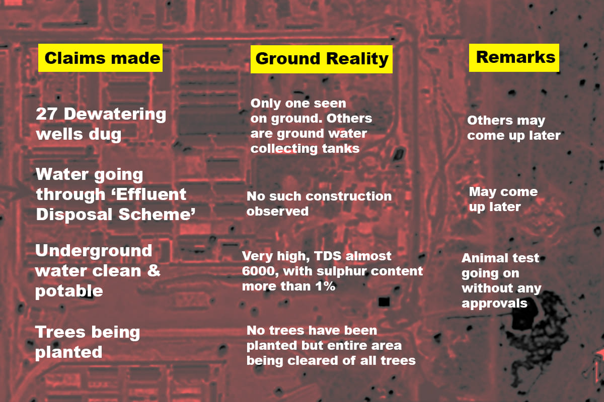 No dewatering wells are seen except just one near the power plant. No effluent disposal scheme is seen in satellite images either. A few ground-level water collection tanks are observed though.
The water has a very high level of total dissolved solids (TDS) — minerals, salts, metals or anions dissolved in water. A close analysis of the satellite images suggests that the water in these ground tanks is very heavy in sulphur content.
The depth of the first aquifer is about 125 m and the second is below the coal layer — 190-200 m depth. These aquifers are what make it very dangerous for the miners.
The Phase II mine is barely 10 km from the Indian border. China sitting at such close proximity to Indian border in Pakistan and taking 95 sq km of land on lease for 30 years can be a serious security threat for India.
Request confirm the place is Islamkot & not Islamgarh. Thx