


New Delhi: Australia rejected China’s maritime claims over the South China Sea and wrote to the United Nations Thursday, stating that there was “no legal basis for China to draw straight baselines connecting the outermost points of maritime features or ‘island groups’ in the South China Sea”.
In mid-July, in another substantial statement, the US government had also rejected nearly all of China’s claims over the South China Sea.
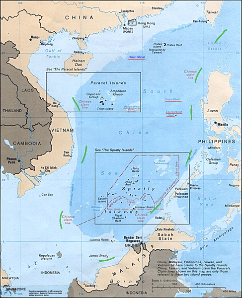
Southeast Asian countries like China, Vietnam, the Philippines, Brunei, Malaysia and Taiwan have disputes over the contentious South China Sea region for centuries. The two primary points of contention are the Spratly Islands and the Paracel Islands in the sea.
Beijing stakes claim to most of the region and at the heart of this claim is the U-shaped ‘nine-dash line’ that includes as much as 90 per cent of these waters. This dotted line was adopted from Chinese maps in the 1940s, and represents Beijing’s claim over the sea and all the land features that are contained within the line.
Here is a look at the origins of the nine-dash line, the history behind it and its meaning in geopolitical terms.
Origins of nine-dash line and what it means
China currently claims ‘indisputable sovereignty’ over the South China Sea, and some Chinese officials refer to it as the country’s ‘blue national soil’ — a term used to refer to the country’s offshore waters.
The origins of the nine-dash line can be traced back to the official maps made by the Nationalist Kuomintang (also known as the Chinese Nationalist Party) government before and after World War II, according to the book, Asia’s Cauldron, by US scholar and strategist Robert D. Kaplan.
Eventually, Mao Zedong’s Communist forces defeated the Kuomintang government, who then fled to Taiwan, establishing their rule there. As a result, both the People’s Republic of China and Taiwan officially claim ownership over the South China Sea.
The nine-dash line was originally an 11-dash line, and Chinese geographer Yang Huairen helped etch it. Yang was born in 1917 and pursued his education in the UK before being employed by China’s Nationalist government.
“In 1947, he worked on the map introducing the 11-dash line and 286 bits of rock and turf in the South China Sea. Yang helped to officially name each chunk of rock and reef, referring to the territory collectively as the ‘South China Sea Islands’,” noted a feature in Time magazine.
In 1949, when the nationalist government lost to the Communists, and relocated to Taiwan, Yang stayed back. However, he was eventually persecuted as an “anti-revolutionary academic authority” during the Cultural Revolution — a sociopolitical movement in China from 1966 to 1976 — for his role in the Kuomintang government.
But Yang’s conception of the U-shaped line would stay on. In 1952, the 11-dash line became the nine-dash line when in a moment of Communist camaraderie with Vietnam, Mao gave up China’s claims over the Gulf of Tonkin.
“Each of the dashes, according to both the Chinese and the Taiwanese, represents the median line between the islands within the South China Sea and the large landmasses comprising the sea’s littorals,” wrote Kaplan.
He also quoted Professor Kuan-Hsiung Wang of the National Taiwan Normal University, as saying, “The purpose of the dashes is to claim ownership of the islands and their offshore waters within the cow’s tongue, rather than ownership of the whole South China Sea itself.”
Also read: New US position on South China Sea raises risk of clash with China at sea
China’s ‘historical’ claims over the South China Sea
For long, China has argued that its claim over the South China Sea is historical in nature. Several Chinese analysts and academics contend that the islands of the South China Sea were first discovered by China’s Han dynasty more than two millennia ago.
According to Kaplan, these scholars have further argued that a Chinese mission in the third century A.D. to Cambodia “made accounts of the Paracels and Spratlys”. Then between the 10th and the 14th century, during the period of Song and Yuan dynasties, many official and unofficial Chinese accounts show the South China Sea to be within China’s national boundaries.
However, this ‘historical rights’ argument has been challenged on several fronts.
First, there is scant proof that China has controlled the South China Sea after the mid-17th century.
“Indeed, after a burst of seafaring exploration during the Ming dynasty (1368-1644), China’s emperors largely shut their empire off from the seas,” said Wang Ying, a Chinese marine geographer and a student of Yang, to Time.
She argued that as a consequence, there is scarce cartographic proof of China’s rights over the South China Sea.
Second, as argued by Kaplan, most of the land features and islands within the South China Sea are just “microscopic bits of earth with little history behind them and basically no civilians living on them”.
This complete lack of history and culture made it easy for China and even other Southeast Asian countries to turn them into “symbols of patriotism and nationhood”, he added.
Also read: Nothing fishy about India-US naval exercises. Message for China is to get ready to fight
The geopolitical significance of the nine-dash line
While the concept of nine-dash line has been around since 1947, for the longest time even the Chinese maps hardly gave it any prominence.
However, this began to change in 2009, when a map marking the nine-dash line was included in the documents submitted by China to the UN during a dispute with Vietnam.
Today, Chinese passports are “emblazoned with a map with nine dashes through the South China Sea”, as well as a tenth one that ensures Taiwan is counted as Chinese territory, noted the feature in Time.
However, there still exists great ambiguity over what China’s nine-dash line implies.
According to Wang, “The dash lines mean the ocean, islands and reefs all belong to China and that China has sovereign rights. But it’s discontinuous, meaning that other countries can pass through the lines freely.”
Other scholars, however, believe it represents a lot more.
Marina Tsirbas from the Australian National University fears that the nine-dash line is a “maximalist claim to sovereignty and control over all of the features, land, water, and seabed within the area bounded by the nine-dash line. This is indeed what many states fear.”
Also read: China has created challenges across the world, UK watching LAC situation — new British envoy
Chinese are thieves, spies and liars.
They just murdered 600,000+ innocent people all over the world.
chill there karen, not all chinese are like that