

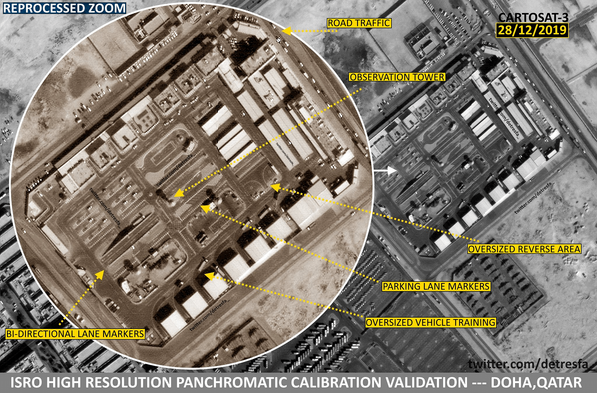
Bengaluru: You can see the parked cars and the road markings, even distinguish small vehicles from the larger ones — images taken by Cartosat-3, India’s most sophisticated satellite ever, are stunning observers with their clarity.
Earlier this month, the Indian Space Research Organisation (ISRO) released images captured by Cartosat-3 over Qatar.
The images are still being calibrated — or fine-tuned — to improve their quality, but even the unprocessed images offer a clear bird’s-eye view of the West Asian nation.
Meanwhile, social media users have begun processing the images released by ISRO to test their quality. The samples posted by one such Twitter user, @detresfa_, show a level of detail unprecedented for satellite images.
Reprocessed zooms of #Isro's recently released (ongoing-calibration) #Cartosat3 images show a MAJOR leap & upgrade of imaging capabilities, not only are distinctions in types of vehicles visible, road markings now show up as well
apart from other observations #India https://t.co/03ExO4cnKz pic.twitter.com/AciD8H8ssZ
— d-atis☠️ (@detresfa_) January 30, 2020
Zoomed-in images show vehicles slotted in parking lanes, which can be clearly seen as lines on the ground, and traffic too.
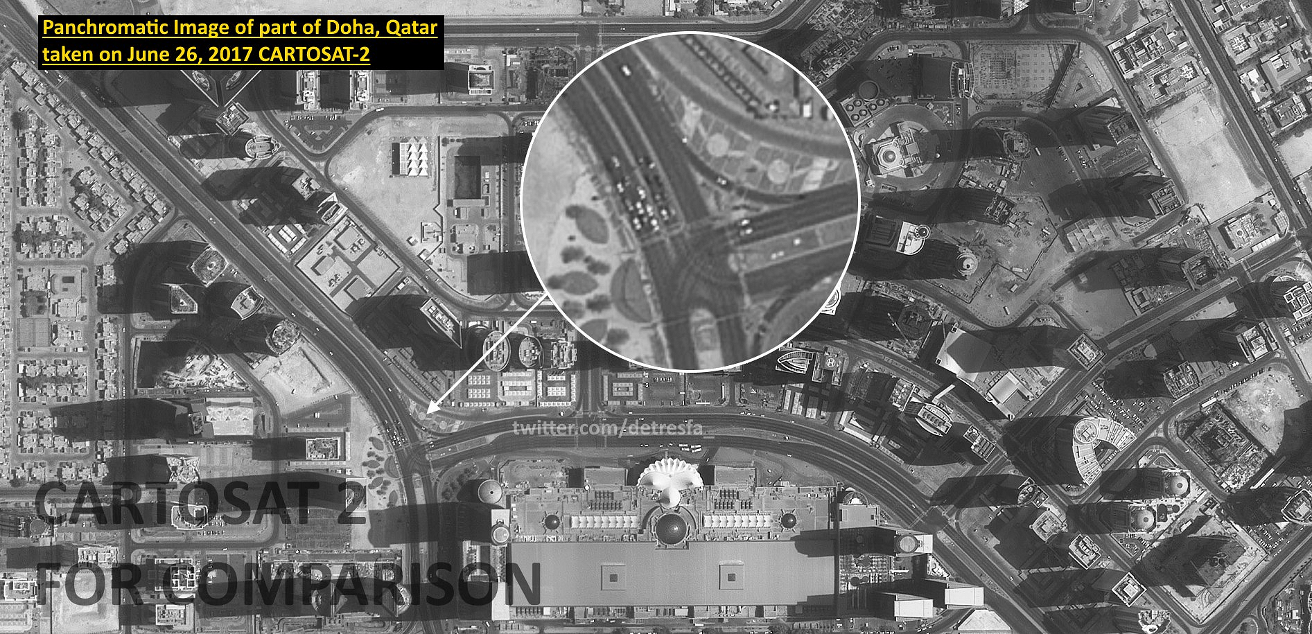
Comparison with images of Doha taken by Cartosat-3 predecessor Cartosat-2 reveal the impressive leap in technology at play.
Also Read: Cartosat-3 in space — here is how ISRO can now exploit its full potential
Best in the world
Cartosat-3 is a third-generation advanced satellite with very high-resolution imaging capability. The satellite will be used for a variety of earth-observation applications, such as cartography, weather mapping, forest surveys, urban planning, coastal studies, mineral prospecting, and, of course, military purposes.
One of its most important uses will include disaster relief operations, where such high-resolution imaging over a vast swathe of area can help save hundreds of lives.
It is a panchromatic, multispectral and hyperspectral satellite, all of which are characteristics that bolster the quality of images it captures.
Multispectral indicates that the satellite can see in three to 10 bands of the electromagnetic spectrum. The satellite’s multispectral resolution is 1.13 m with a 16 km swath in four bands.
Hyperspectral suggests hundreds of thousands of narrow bands being imaged. The satellite’s hyperspectral resolution is 12 m with 5 km swath.
Where Cartosat-3 stands out is in its panchromatic resolution. Panchromatic indicates its sight in the visible part of the spectrum — Cartosat-3 has a ground resolution of 0.25 m with 16 km swath. This means the satellite can pick out an object that is 25 cm long in an area 16 km wide.
Its imaging resolution is the highest ever developed by ISRO. Its panchromatic resolution is also the best known commercially for a satellite in orbit. With its imaging capacity, Cartosat-3 replaces WorldView-4, an American satellite with a resolution of 31cm.
The 1625-kg Cartosat-3 is the ninth satellite to be launched in the Cartosat series. The series has been active since 2005 with the launch of Cartosat-1 and will form a part of the ISRO’s Indian Remote Sensing Programme.
Also Read: Why ISRO’s Cartosat-3 is most complex and advanced satellite India has built