


Twelve days after the foreign ministers of India and China met in Moscow, the two sides held the much-awaited Corps Commander-level talks at Moldo to work out a comprehensive plan for disengagement and eventual de-escalation at the Line of Actual Control.
The joint statement released on 22 September says: “They agreed to earnestly implement the important consensus reached by the leaders of the two countries, strengthen communication on the ground, avoid misunderstandings and misjudgments, stop sending more troops to the frontline, refrain from unilaterally changing the situation on the ground, and avoid taking any actions that may complicate the situation.” A rather long sentence, but one that does not hold any hope that things will get better anytime soon. If anything, it is indicative of the diplomatic impasse and a likelihood of continuation of the volatile status quo.
I analyse the situation with respect to the People’s Liberation Army (PLA)’s physical control of the 1959 Claim Line with focus on Sub Sector North (SSN), popularly known as the Depsang Plains or Daulat Beg Oldi (DBO) Sector.
Also read: Xi’s motivations behind LAC standoff and why China has been hyperactive since 2017
PLA status — 1959 Claim Line
China’s immediate political and military aims — to prevent India from developing border infrastructure that threaten Aksai Chin and other areas captured before/during the 1962 War — are achieved by securing territory up to the 1959 Claim Line, first mentioned in Zhou Enlai’s letter to Jawaharlal Nehru. Since May this year, China has physically secured the1959 Claim Line in Galwan, Hot Springs-Kugrang River-Gogra and North of Pangong Tso. In SSN, it is yet to assert its physical presence, but has aggressively prevented our troops from patrolling up to the LAC. The deployment of our troops is restricted to the West of the 1959 Claim Line. The only other area left is Demchok, which being inhabited, may be left for later resolution/usurpation.
The 1959 Claim Line is strategic in concept and tactically forecloses all Indian options to threaten Aksai Chin and other areas under Chinese occupation. This line also makes our defences in SSN, Hot Springs-Kongka La-Gogra, and North of Pangong Tso extremely vulnerable to isolation and defeat.
In the next two months, both sides could prepare and settle for continuation of the status quo or either side may attempt to raise the stakes in tune with its political and military objectives. Given the differential in capabilities and the tactical advantages gained by the PLA through its preemptive operations, the probability of India raising the stakes is low. The likely pattern of a PLA offensive in a limited war has been discussed by me earlier. This analysis is restricted to examining the probability of the PLA securing the 1959 Claim Line through controlled escalation in SSN.
Also read: LAC crisis will be a long haul, can cost both India and China
Terrain evaluation of SSN
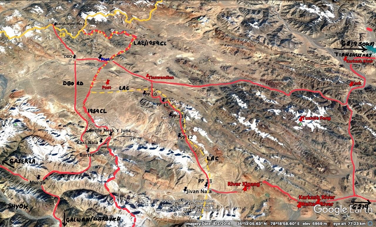
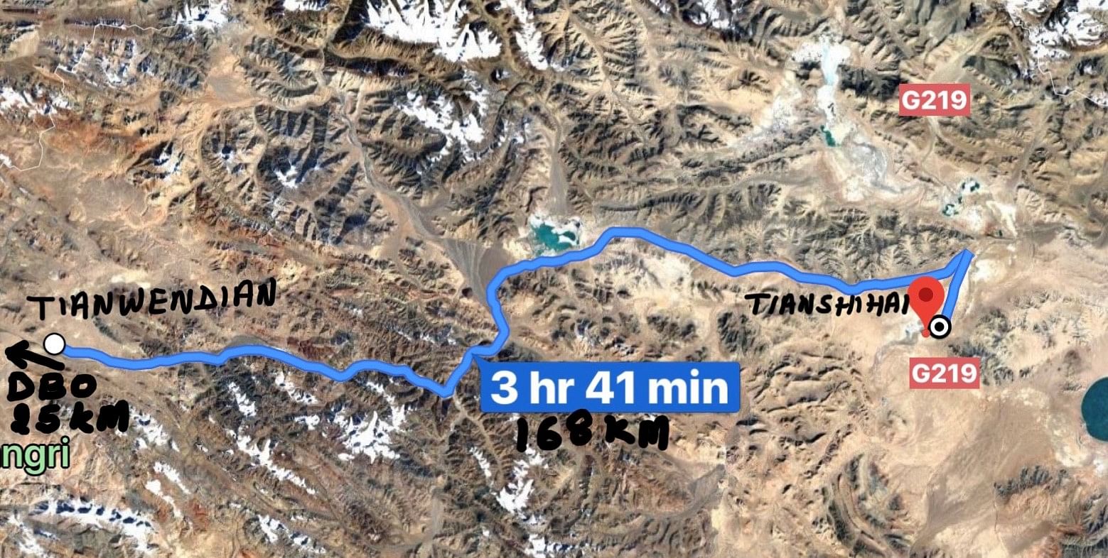
Depsang Plains are an extension of the Tibetan plateau with a base height of 5,200 meters (17,000 feet), interspersed with gradual hill features up to heights between 5,500-6,000 meters (18,000–19,500 feet). The plains are irregular in shape, measuring 60-70 km west to east and 40-50 km north to south. To the north, they are bounded by Karakoram Range; to the east, by Lak Tsung Range, the western watershed of Karakash River; and to the south by the Shahi Kangri Range. Siachen glacier is 50km to the west. The terrain, including gradual hill features, can be easily negotiated by wheeled and tracked vehicles. Hence, the area is conducive for mechanised operations. See image below.

As I had written in my article on 28 may, Depsang Plains are “our vulnerability due to the tenuous lines of communications, notwithstanding the recommissioned Daulat Beg Oldi airfield that lies within the artillery range of the LAC. It is also the only area that provides direct access to Aksai Chin from India. China does not want any threatening build-up in SSN. Fifteen years ago, a Chinese military war game was conducted that visualised a division size force along with a mechanised force, launching an offensive from SSN into Aksai Chin.”
“Keeping in view our vulnerability, we began constructing two roads to SSN in 2007. The first was from Sosoma in Nubra River valley via Saser La pass. Unfortunately, Saser La is snowbound. Unless we make a tunnel, it would, at best, remain a summer road. The second road, 255-km-long, was built along the Shyok River valley from Darbuk via Murgo and Depsang. While this is a marvel of engineering through the gorges of Shyok River, unfortunately, it runs parallel to the LAC. At the junction of Shyok and Galwan rivers, it is only 5 km from the LAC.”

Also read: Linking LAC peace with good relations shows India still doesn’t get China
LAC versus the 1959 Claim Line in Depsang Plains
The 1959 Claim Line runs north to south from the Karakoram Range via Bottle Neck/Y Junction and further south to Jivan Nala. Prior to 1962, our posts were 5-10 km to the East of the Claim Line in the northern half of the plain, opposite DBO airfield. In the Southern half, these were 30-40 km east of Bottle Neck. In 1993, the LAC coincided with the 1959 Claim Line in the northern half of the plains, but East of the Bottle Neck, it was at 18-20 km. However, we never physically occupied the southern half of the plains and with a base at Burtse, the Indo Tibetan Border Police patrolled up to Patrolling Points 10, 11, 12 and 13.
Once we constructed the DBO Road and started developing lateral roads to the LAC, the PLA wanted to deny us the depth of 20 km east of Bottle Neck, and hence, reasserted its claim through the face-off in 2013. After the face-off, we continued patrolling up to the LAC until April this year. As on date, the PLA is preventing our patrols from going east of Bottle Neck. However, it seems that it has not physically deployed troops in strength.
Also read: Pakistan’s ‘upgrade’ of Gilgit-Baltistan is linked to the India-China stand-off
Prognosis
The probability of the PLA securing the southern half of the Depsang Plains up to Bottle Neck to reach its 1959 Claim Line are very high. This is a low-hanging fruit for the Chinese because we have not contested the stopping of our patrols since May. Given our vulnerability, it is unlikely that we will preempt or contest the PLA’s actions.
The 1959 Claim Line is now likely to be the new LAC in all areas, except Demchok. However, since formally accepting the 1959 Claim Line would undermine the domestic reputation of Prime Minister Narendra Modi’s government, the most pragmatic solution could be to declare the entire area between the 1959 Claim Line and 1993 LAC as an extended buffer zone, where no troops will be deployed or any defences/border infrastructure created. This can be a face-saving solution for both Modi and Xi Jinping. An agreement on above lines may pave the way for disengagement and de-escalation before the winter sets in.
Lt Gen H S Panag PVSM, AVSM (R) served in the Indian Army for 40 years. He was GOC in C Northern Command and Central Command. Post retirement, he was Member of Armed Forces Tribunal. Views are personal.