


It is widely known that the Siachen Glacier region caught the attention of the Indian military planners only around 1978 when Colonel Narendra ‘Bull’ Kumar’s attention was drawn to it by two German explorers, Volker Stallbohm and Jaroslav Poncar and he flagged it to the higher authorities. Incidentally, both Stallbohm and Poncar had explored Siachen from the Pakistani side in the summer of 1978 with Wolfgang Kohl and Major Asad Raza.
While Kumar and Lt. General ML Chibber’s accounts detailing the Indian interest in Siachen are well known, Poncar and Stallbohm give fresh insights into their own fascination with the region and their interactions with Kumar on the subject.
“After the Indus expedition of 1975 with Bull and others, the DC Leh, Mahmood Rahman suggested that we paddle down the Nubra from its source i.e the Siachen Glacier. However, that did not happen as Nubra Valley was in a totally restricted area,” recalls Poncar.
He went back home and read more about the glacier and the explorations of Tom Longstaff, Fanny and William Workman, and Giotto Dainelli in the region and started thinking about an expedition.
“In the summer of 1976, we were back in Zanskar and I again met Bull. When I suggested exploring Siachen, the longest glacier in the world, he rejected the idea saying there is no adventure in walking on long glaciers,” he added.
The year was 1977. By this time Stallbohm was infected with mountain fever from the two trips to the Western Himalayas and started searching for peaks to explore in the Eastern Karakorams when his eyes fell on the Mamostong Kangri, a peak above 7,000 mtrs lying on the eastern flank of the Siachen Glacier and easily accessible via the Nubra Valley. Excited at the prospect of a fresh ascent, both the explorers started planning another trip to India.
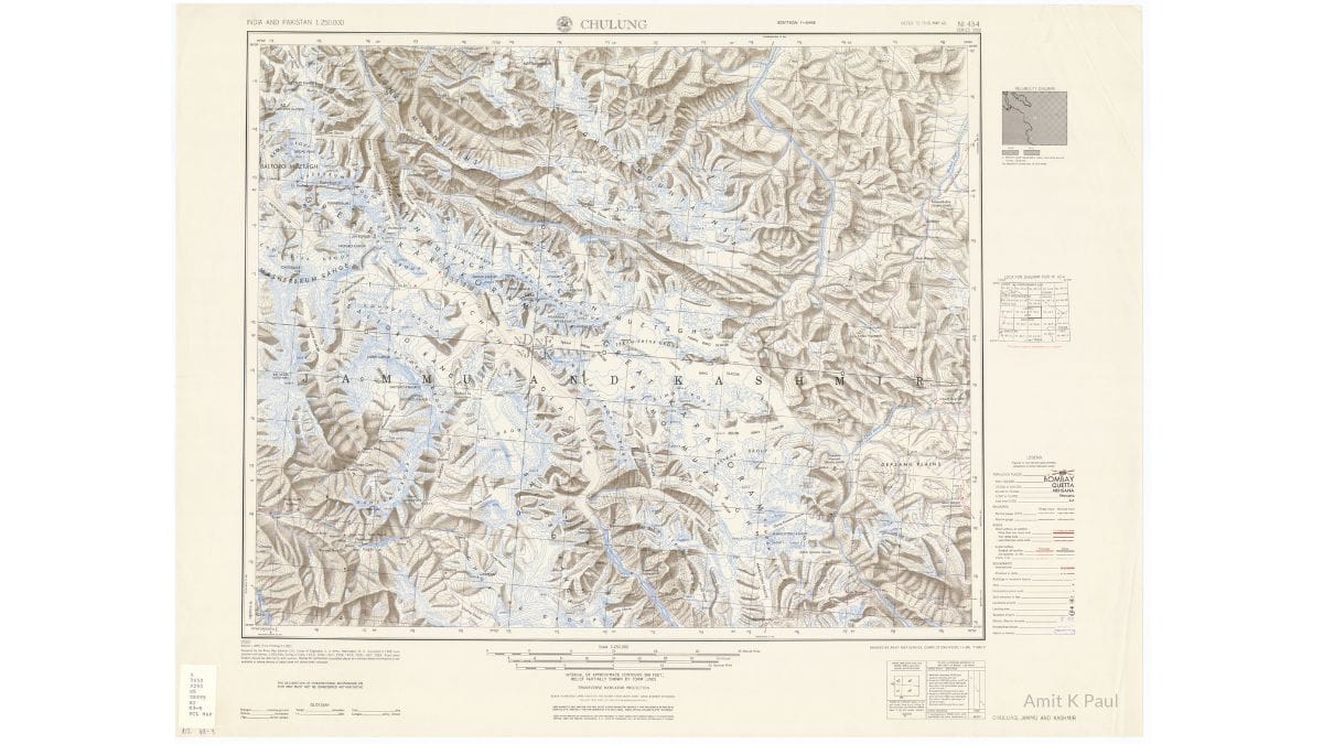
‘I went to the Gleumes Geobuchhandlung—a geographic bookstore in Cologne (now closed) and bought some maps of the region compiled by the AMS (American Map Service) in 1953 (Scale: 1:250,000) as part of the U 502 Topographic Series titled India and Pakistan and published in 1955. The Chulung Sheet (NI 43-4), Leh Sheet (NI 43-8) and Shyok Sheet (NI 44-5) were readily available and I gave them to Stallbohm who quickly drew up a route description to Mamostong as well as Saser Kangri using all the three sheets,” remembers Poncar.
Volker flew to Delhi with the plans and met Sheikh Abdullah and Kumar in the summer of 1977. The explorers thought their support for the Mamostong Expedition would help them get permission easily.
“I met Bull in 1977 and gave him the map to explain the route for the proposed expedition. I brought the US Army Service map and most of the references to Siachen are in the Chulung Sheet. The project came to nothing, but the map in the hands of Bull probably became the basis for the imminent conquest of the Siachen Glacier by the Indian Army,” rues Stallbohm.
Also read: Many good reasons to demilitarise Siachen. But India-Pakistan ties too torn to allow it
Marking of LoC
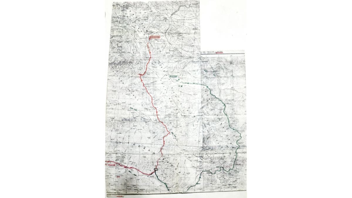
In all accounts attributed to Kumar, there is a reference to some map (s) given to him by the Germans in which the Line of Control has been extended to the Karakoram Pass and the region incorrectly depicted on the Pakistani side. When this author interacted with Kumar and probed him on the subject, Kumar vividly recalled the Indus Expedition, his association with the Germans, and his meeting with Stallbohm. He also recalled coming across maps showing a line going towards the Karakoram Pass and handing everything to the Director of Military Operations. However, he did not remember which specific map(s) he handed over to the DMO or the contents of the map(s) given to him by Stallbohm. Now both Poncar and Stallbohm confirm that it is the route map to Mamostong Kangri with the Chulung Sheet (showing Mamostong on the Chulung sheet).
The map handed over by Stallbohm to Kumar does not have any line demarcating the boundaries between India and Pakistan. “I don’t know what Kumar did with our map. Maybe it triggered his interest in the region and he started his own search discovering some other maps which extended the control line to the Karakoram Pass. Whatever it was, it was his own conclusion and our maps had nothing to do with it,” says Poncar.
Stallbohm confirms that in the map he gave Kumar most parts of Siachen are on the Chulung Sheet, and there are no annotations, remarks, or demarcation lines of any kind between India and Pakistan. “So, I do not know how Kumar could use it or some mystery about the American map to justify his incursion. All other subsequent affirmations are the sole responsibility of Kumar,” he says.
What emerges from research thus far is that Kumar being a mountaineer, was fascinated with the maps of the region given to him by Stallbohm as he had never seen them before. With the idea of an ascent planted in his mind, these maps in his hand acted as a catalyst for further probes into the mountaineering activity taking place in the region. Probably during the course of this search, he dug out details of various expeditions coming into the region from the Pakistani side and also discovered maps extending the control line to the Karakoram Pass.
Agitated about permissions being given by Pakistan while no such permissions were given in India, and alarmed by the spate of mountaineering activity and extension of the control line in some maps, he approached then DMO Major General ML Chibber with all the information around January 1978. Once all facts were ascertained and appreciated by the DMO, an Indian reaction was naturally imminent and it came in the form of a reconnaissance mission to Teram Kangri under Kumar, which landed on the glacier in 1978—within three months of the German expedition.
Since all these events occurred in close succession, it appears that while recalling the facts many years later, Kumar inadvertently attributed the cartographic error to the map given by Stallbohm when notably during this period there were several maps in circulation which visually extended the LoC to the Karakoram Pass by joining these two points in a straight line. These included, inter alia, some US State Department maps of Jammu and Kashmir, US Tactical Pilotage Chart TPC-G7D complied in 1967, US Operational Navigation Chart ONC G-7 of 1974 and maps in some popular Atlases, any of which could have caught Kumar’s eye while making his enquiries and passed on further.
Today though both Stallbohm and Poncar regret meeting Kumar, handing him the maps and inadvertently drawing his attention to Siachen, thankfully for India, Kumar’s curiosity, his timely sharing of all the information with the top brass and its correct assessment by them enabled the Indian army to pre-empt Pakistan from occupying it by launching Operation Meghdoot on 13 April 1984.
The writer is an independent researcher and author of ‘Meghdoot: The Beginning of the Coldest War’. This article is based on his personal interviews and online interactions with Colonel Narendra ‘Bull’ Kumar, Volker Stallbohm and Jaroslav Poncar. Views are personal.
(Edited by Theres Sudeep)