


New Delhi: The Bhakra Dam has been standing since 1963. Since 1963, this is the tallest gravity dam in all of Asia. A gravity dam is different from other dams. Tehri Dam, for example, although taller than the Bhakra Dam, is not a gravity dam.
As we go along, I will in a very cursory manner try to explain the difference to you because if I go any deeper, that will take me into the area of civil engineering and I will be out of my depth. Sorry for the pun. We are talking about dams and water storage.
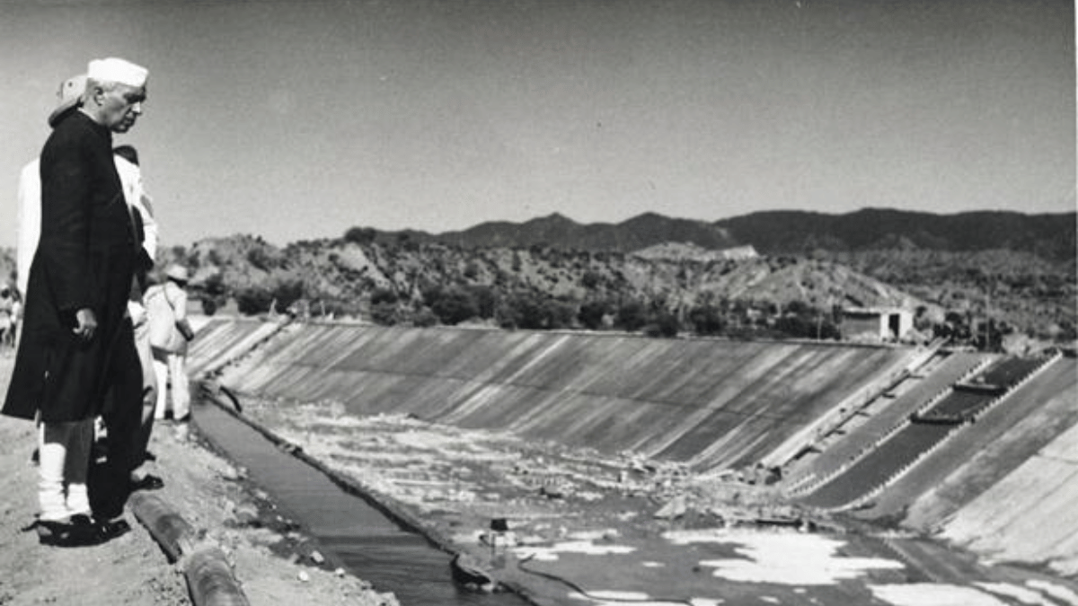
Bhakra Dam has transformed North India—definitely Punjab, Haryana and parts of Rajasthan. The Indira Gandhi canal, which goes right through Rajasthan also draws water ultimately from the Satluj-Beas system.
The Satluj river which is dammed by the Bhakra Dam also receives water from the Beas ultimately. That is the reason the system is called the Bhakra-Beas Management Board. The origin of the entire series of dams and barrages, which starts high up and then goes right up to the India-Pakistan border near Sarospur at a place called Harike Pattan, which is the final confluence of Satluj and Beas, is where all the water is trapped and put into the Indira Gandhi canal, the Rajasthan branch, the Sarospur branch and the third canal called Machu canal.
The idea is that none of this water should go to Pakistan because as we know India has the full right over the waters of the three eastern rivers of Punjab—Satluj, Beas and Ravi. The western rivers are Indus, Chenab and Jhelum. Those are the ones which were earlier governed by the Indus Waters Treaty, which India has now put in abeyance. That picture we need to know.
Now, this Bhakra Dam starts off a system. It is at an altitude, in a gorge. This is when the mighty Satluj river is just falling down a big gorge. What happens when a river falls down a gorge? It gives you the opportunity to generate that fall and the power in it into electricity, and that is what happens. When it was formed, it was one of the biggest power generating dams in the world and definitely the biggest in India. 1,500 megawatts.
Over time however, its purpose has been much more irrigation and also in some ways, flood control. 13 kilometres below the dam is Nangal. It is a stabilizing system. All the turbulent water falls from Bhakra, which the Nangal barrage stablises.
Bhakra has a huge reservoir. Now, a huge reservoir creates its own problems. Think about this. Everybody needs rest. Any machine also needs rest. But, do dams need rest? A dam which is filled with so much concrete, does that dam need rest? The fact is, yes, it does.
And what happens if it doesn’t get rest? One of the outcomes of a dam not getting rest is that it may get tired and may start tilting. Even if a human being carries too much weight on their backs, they tilt. If they keep on doing it all the time, that tilt becomes sort of permanent and problematic. That is what happens to dams too. However powerful a dam might be, it’s holding back large amounts of water.
The Bhakra Dam is holding back water that covers a lake 90 km long. It has devoured a lot of land, including the entire Bhakra village. 168.34 sq km storage of water is being held back by this dam.
As a consequence, this dam has begun to tilt a little bit. The time to make some changes and do some damage control is now. I will explain to you how this happens.
The Bhakra dam was conceptualized by the great Jat leader, Sir Chotu Ram, in 1923. In 1944, Sir Chotu Ram, as revenue minister of combined Punjab, a big territory then, signed an agreement with the Raja of Belaspur to build this dam on a gorge that he had identified. By 1945, the project report was ready and in 1948, the construction work started. However Nehru, ceremonially poured concrete in 1955. The dam was completed in 1963.
When engineers design dams, they don’t design them for 20 years, 50 years, or a couple of generations. They design them for at least a couple of hundred years. These humongous investments cost a lot. They also carry an environmental and human cost. People are dislocated and a lot of the forest is submerged. Which makes it important is to get a value for all of it.
When designing these dams, engineers take into account the factors of pressure and strength—the strength of the dam and how much pressure or weight it will face. All these calculations are done by civil engineers.
Now, when a dam holds this much weight, it will tilt a little bit, because the structure cannot be fully stationary. Now, in the larger scheme of things, given the size of the Bhakra dam, which is 190.5 m or 625 ft at the bottom and about 518 m or about 1,700 ft at the top—when it holds back all of this water, it tilts just a little bit. Engineers make provisions and put maxima to that.
The maximum tilt that Bhakra Dam is designed to take is 1.03 inches, which is a lot for a massive structure like that. It has lately however shown a higher tilt. In November last year, it tilted 1.177 inches—way beyond its limit of 1.03 inches, causing some degree of alarm.
The dam had also caused similar alarm when it tilted by about 1.05 to 1.10 inches in 2010, the year of the Commonwealth Games (CWG). Water had topped the dam in what was a big monsoon year, leading to the CWG Village also getting flooded. The floodgates were opened and further filling of the reservoir was stopped as a precaution.
Last year’s tilt of 1.77 inches has also been a cause for concern now. Anurag Thakur, a Himachal Pradesh MP, asked a question about the danger of the tilt and the solution to it in Parliament on 19 March, to which Sripad Nayak, Minister of State for Power, replied.
Later, Bhakra Beas Management Board chairperson Manoj Tripathi, speaking to The Tribune and Hindustan Times, said that while there was no immediate threat to the dam, it was true that the permissible tilt was 1.03 inches and the dam was touching 1.77. He said that though it was not alarming, it was a sign that the dam had been taking too much weight. He added that they were assessing the situation and taking preventative measures.
One of the measures involved the Bhakra Beas Management Board signing a consultancy contract with IIT Roorkee, a premier civil engineering center in India and Asia, and globally reputed. It has paid Roorkee Rs 3 crore and asked it to produce a report within six months to a year as to what to do about the tilt and how to protect and strengthen the dam. Another Rs 1.3 crore has been allocated to a foreign consultant, should one be needed. These are also the answers that Shripad Nayak has given in his parliamentary reply to Anurag Thakur.
A somewhat more explicit statement from the Bhakra Beas Management Board, Secretary B.S.Sinhmar says, ‘The deflection of the dam has always been a baseline concern, but now, for the first time, we have decided to get a deep study done to know the real scenario.’
Now let’s understand the dam a little bit. Bhakra is a gravity dam. Although the Tehri dam is taller, Bhakra dam is the tallest gravity dam in India and Asia. Pakistan is currently building Damar Basha Dam, which, at 27 m or 892 ft, will be taller than Bhakra and the tallest in Asia when completed. The Chinese are helping them build it. China is also building a dam on the Brahmaputra or the Yarlung Tsangpo as it is called there.
We spoke about it in another episode of Cut The Clutter. We do not really know how high the dam might be, with the Chinese having so much possibility of producing power.
The other tall gravity dams in Asia right now are Longtang in China—216.5 m and the Three Gorges Dam—181 to 185 m. Bhakra itself is 226 m.
A gravity dam means that it stands on its own weight, filled in with massive amounts of concrete, stones, and masonry. In contrast, the Tehri Dam is like an embankment dam, whose engineering is very different from a gravity dam.
One more difference between a gravity dam and an embankment dam is that the former can have a very narrow width, while the latter usually tends to be very long. The narrowness helps it make the best use of the available gorge in a mountain. An embankment dam like Tehri Dam usually tends to be very long.
Bhakra, as we have seen, is not a humongously wide dam. What happened to all the water that the dam stores in its reservoir? It is a small, narrow dam, which means all of the water pressure is on this structure. The dam, although designed to carry maximum weight, is not designed to carry the maximum weight 24/7, 365 days every year.
The design is such that engineers calculate that at one point the dam will be filled to its capacity, which in the course of time shall go down as water keeps being used as India is a monsoonal country. As the water level goes down, the dam will get some rest, essential for its health. The minimum level to which the dam can go and should go annually is 1,472 ft.
However, that has not been happening for 10 years as India has had reasonably good monsoons. We haven’t really had a drought year, despite some poor monsoon years. As a result, water level has never gone to the minimum drawdown level of 1,472 and the dam has had to bear more weight throughout the year. It hasn’t got its own little power nap.
Desilting operations can also be conducted when the water level is at a minimum, which is not possible when the level is high. Bhakra has been silting since the time it was constructed in 1963 and has lost 25-26 percent of its storage capacity as silt comes down the Himalayas. Although a silt storage margin of 33.61 million cubic meters had been reserved as dead storage space, deforestation has led silting to exceed its limit to 38-39 million cubic meters. That is how the reservoir’s water storage capacity is coming down.
Last year, the Jal Shakti Ministry set up a 10-member committee to look at the prospects of desilting the dam. It is a little bit ironic that we are now saying that because we put the Indus Waters Treaty in abeyance, we can start desilting in the western rivers since the Pakistanis were putting objections and not letting us do it so far. Whereas, the fact is that we have not carried out any desilting operation even within our own rivers and from our own reservoirs. This is going to be a very complex one.
Yet for that to happen, the water in the reservoir needs to be brought down to minimum drawdown levels. Shripad Naik reiterated the same when he said in his Parliament answer that negotiations were now taking place with various stakeholder stakes including Punjab, Haryana, Himachal and to some extent, Rajasthan—as all of them are in need of this water.
It is up to them to decide whether they want this water preserved for a bad monsoon contingency or risk water levels coming down to 1,472 ft let some repair work and desilting happen, also allowing the dam to rest in the process.
India has the third largest number of dams (6,628), consisting of both large and small, after China and the United States. 6,545 are operational and 83 are under construction.
Now, do dams collapse? Research and global data says that tilts are actually responsible for no more than 5 percent of the dam collapses in the world. But if a tilt is combined with other factors—cracks, seepage, and earthquakes, it becomes a more dangerous factor. When such a big asset holding back so much water is being looked at, the worry has to start a century before it becomes a crisis. The crisis may not be that long away. Hence, the cause for alarm now.
Seepage of normal water levels. Sometimes you can get too much water and I will give you the examples of 3 significant dam collapses that we have had in India and you will see how these were.
One was the Morbi or Machu Dam Collapse in Gujarat that was on 11th of August 1979. That was a case of suddenly too much water coming in. That was a relatively new dam built in 1972. That dam was designed say for X amount of water but you had such a torrential rain then that the dam had to withstand two and a half times the water flow for which it had been designed. That dam collapsed and thousands of people died.
The second was Koinar Dam in 1967 which was sort of obliterated by an earthquake where hundreds of people died. And third is the 2023 Teesta tragedy. This was when 15 million cubic meters of frozen ice and debris collapsed into South Lhonak Lake, which feeds this dam. That led to a flow of water which the dam could not withstand. So that water took the dam with it and the momentum of the dam and the debris going down destroyed everything that came in the way. So you have seen all three possibilities.
First, simply torrential rain. Unexpected torrential rain bringing two and a half times the weight of water that the dam was designed for. That was Morbi. Number two, an earthquake taking down Koinar. And number three, Teesta where a catastrophic 15 billion cubic meters humongous amounts of frozen sentiment fell in the Lhonak Lake. And that led to the pressure so the dam collapsed.
Dams don’t collapse so easily. They are built really strong. However, if you see a little bit of vulnerability develop the time to fix that. And once again, when you look at Bhakra, silting also becomes very important because increasingly the storage capacity of the dam is coming down. And all of the regions that depend on Bhakra water do not want that to happen. And that’s why desilting the Bhakra reservoir is now a top priority.
(Edited by Tony Rai)
Also Read: 5 global oil shocks in 53 years: How they caused upheaval, forced reforms in India | Cut The Clutter