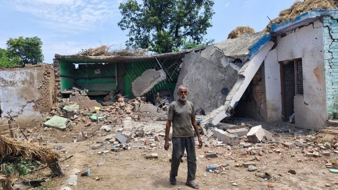
Akhnoor: For Bachan Lal, a 60-year-old farmer and resident of Nai Basti—near the International Border (IB)—enduring the shelling by Pakistan has been a part of life. For decades, the villagers have lived with the constant fear of the next “attack”. Even spending too much time on the roof is fraught with danger due to snipers positioned on the other side of the border fence.
“It (shelling) happens all the time without warning… We have to give this a befitting response. We have become used to this. We want the government to give us some land a little away from here. When there is firing, we can leave and return when it’s over. Our life is here and we have to live here,” Lal told ThePrint.
Nai Basti is a tiny village that comes under Pragwal in Jammu district’s Akhnoor—historically one of the most targeted regions in the long-standing conflict between India and Pakistan.
This and many other villages fall in a curved line that goes around what Pakistan calls “Akhnoor Dagger” and India calls “Chicken’s Neck”—a 170 square km stretch of Pakistani territory jutting between the Chenab river and one of its channels, surrounded by Indian territory on three sides. Since independence, this area has been impacted by every war and flare-up between the neighbours, and its importance has only increased since the wars of 1965 and 1971.
Akhnoor town is about 30 km away from Jammu and 50 km from Pakistan’s Sialkot. The aerial distance is even shorter, making this area particularly vulnerable to potential acts of aggression from across the border.
Villages, like Rakh Kharoon and Gharkhal, that fall on the same line were among the first to witness the shelling and drone attacks by Pakistan in retaliation to India’s strikes on terror infrastructure there under Operation Sindoor on 7 May. Lal’s home was also destroyed in the shelling. Residents of villages, like Kota Mera, Pahadiwala and Pargwal, among others, in Akhnoor suffered injuries and damage to property.
Even after the two countries agreed to a ceasefire on 10 May after four days of escalating tensions, these villages in Akhnoor saw drones in the sky as Pakistan committed ceasefire violations the same night.
Akhnoor bridge & ‘Chicken’s neck’
Akhnoor is located on the banks of river Chenab, which then flows into Pakistan-occupied Kashmir. The Akhnoor bridge has been among Pakistan’s top targets for decades. The region’s importance also stems from the fact that it is considered a key supply route connecting Jammu to Rajouri, Poonch and other areas.
According to Ganesh Malhotra, professor of strategic and regional studies at Jammu University, generations of Pakistan’s leadership have believed that capturing Akhnoor would cut off Rajouri, Poonch and other parts of Kashmir from the rest of India. Among these leaders was General Ayub Khan, military leader and president of Pakistan from 1958 to 1969.
“When we talk about (Cyril) Radcliffe, there are prominent accounts to state that he never visited India and drew the lines on the table without looking at ground realities. If you look at the Indian map, there are certain lines that are crucial for an accurate depiction. One of those small details on paper is what Pakistan calls ‘Akhnoor Dagger’ and India calls ‘Chicken’s Neck’, 170 square km and around 66 square miles, that is like jutting into India’s territory,” Malhotra told ThePrint.
“From that area, Akhnoor is very close. Pakistan thinks that through that area, it can capture Jammu.”
There are alternate routes through Udhampur and Ramban that connect to Srinagar, Rajouri and Poonch, among other places.But this has not stopped Pakistan from targeting these parts during war.
In just the second war between India and Pakistan in 1965, the first shelling or attack was made on Akhnoor as a large Pakistan army unit of battle tanks and infantry started moving towards Chamb, and quickly established dominance, threatening to capture Akhnoor.
Jammu was where the fiercest skirmish between India and Pakistan took place, with the latter coming out on top. But advances were cut short as the Indian offensive on Lahore and Sialkot, just about 30 km from Akhnoor, felt the wrath of India’s firepower. India then occupied Haji Pir, a key route that connects Uri with Poonch.
By 1971, Pakistan had realised the importance of the “Dagger”, and tried to use the same strategy to move in on Akhnoor.
While the region was given that name by the Pakistani side, Lieutenant General Zorawar Chand Bakshi, who was the GOC of the 26th infantry division in Jammu during that war, had called it the “Chicken’s Neck” that he said should be wrung and broken off. He wanted to change India’s stance from defensive to offensive.
According to Malhotra, the geography of “Chicken’s Neck” fuels Pakistan’s belief that it has strategic advantage in these parts.
Beyond being an area of focus in the India-Pakistan conflict to this day, Akhnoor holds a special place in Hindu mythology. It is believed to be the mythical Virat Nagri, according to Mahabharata, and the Pandavas spent some time in these parts during the last year of their exile.
The town is said to have got its present name during the Mughal era, derived from the words “aankh ka noor“, meaning light of the eyes.
(Edited by Mannat Chugh)


