In Shakargarh Bulge area, near Punjab and J&K, Pakistan is working on its defences — planting trees, changing course of the Ravi & inundating open spaces.
New Delhi: On 30 November, Pakistani Army chief General Qamar Javed Bajwa was seen attending an exercise with the 30 Corps just a few kilometres away from the Indian frontier in Sialkot.
Just a few days earlier, Bajwa had been spotted planning an armoured offensive action with the II Strike Corps at Multan.

The message is clear — despite recent overtures of peace and harmony from Prime Minister Imran Khan, Pakistan continues to redouble its efforts to shore up its defences in the strategically key Shakargarh Bulge area.
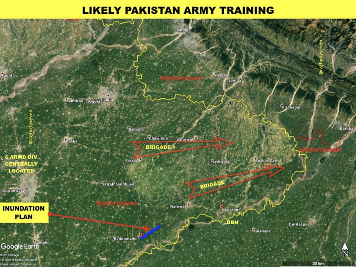
The Sialkot exercise is particularly significant, given its location in the Bulge, a prominent region which juts into Indian territory near Pathankot in Punjab and Kathua in Jammu and Kashmir, and lies very close to the highway connecting J&K to the rest of the country.
Bajwa claimed in Sialkot that “our experience of sub-conventional operations is an addition to our combat-worthiness”.
However, this is not all that the Pakistani establishment has been up to in the area. Satellite images analysed by ThePrint indicate that there are actually three different activities being carried out, including strategic planting of subsidised trees to impede armoured vehicles, the inundation of open spaces near Baddomalhi and Narowal with water from rivulets, and, most importantly for the people of India and Punjab, changing the course of the Ravi river that flows along the border.
Significance of Shakargarh Bulge
During previous wars with Pakistan, India has fought bitter battles in the Shakargarh Bulge, and won significant victories.
The Pakistan Army believes that India’s main thrust would come in this area, especially in a ‘Cold Start’ situation.
In the aftermath of Operation Parakram — the standoff between the armies of the two countries after the 2001 terror attack on India’s Parliament — the Pakistan Army extensively improved its defences in this area. It has two divisions stationed in Sialkot Cantt for quick deployment.
The construction of Sialkot International Airport also has certainly increased Pakistan’s capability to airlift forces in this area.
The new bridge over the river Chenab has reduced the travel time from the city of Gujrat to Sialkot to merely 45 mins. All this is an indication of the importance the Pakistan Army would give to the Shakargarh Bulge in a future war.
Also read: Rare images show Pakistan’s tactical nuclear weapons that may be used against Indian troops
Strategic plantation of subsidised trees
In the Shakargarh Bulge, Pakistan has cleared areas where it expects the Indian Army to advance, and planted subsidised, fast-growing trees.
The subsidised plantations are mainly around rivers and nullahs, making movement across rivers difficult.
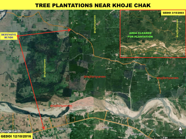
The major plantation observed in the Shakargarh Bulge is south of the ‘chicken’s neck’ area near Khoje Chak, where almost 1,900 hectares of land has been covered with defensive bunds on both sides, denying or delaying free armoured movement.
These plantations would thus channelise Indian Army advances in any skirmish or war.
Movement of the 6 Armoured Division
In a surprise strategic operation, the Pakistan Army moved its 6 Armoured Division from Kharian to Gujranwala in 2010.
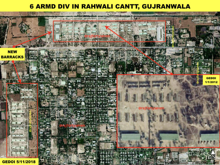
The move avoided time-delay for deployment of this formation into the Shakargarh Bulge. It also avoided the delays in crossing the river Chenab in case of any aerial action by the Indian forces.
Thus, deployment of counter-offensive forces would be quick — fast enough to blunt any Indian offensives in this sector.
Baddomalhi inundation plan
Like in Indian Punjab, the roads and rail lines on the Pakistani side are raised and run parallel to each other. In an innovative move, the Pakistan Army has filled the areas between these raised sections with water from nearby rivulets at a place called Baddomalhi.
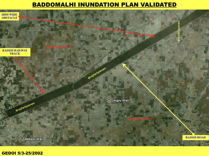
It has thus managed to create a 200-metre wide and almost 8.5-km long obstacle for stopping Indian Army pincers between Baddomalhi and Narowal on the southern edge of the Shakargarh Bulge.
Changing the course of the Ravi
A close study of satellite imagery over the last four-five years makes it clear that Pakistan is changing the course of the river Ravi.
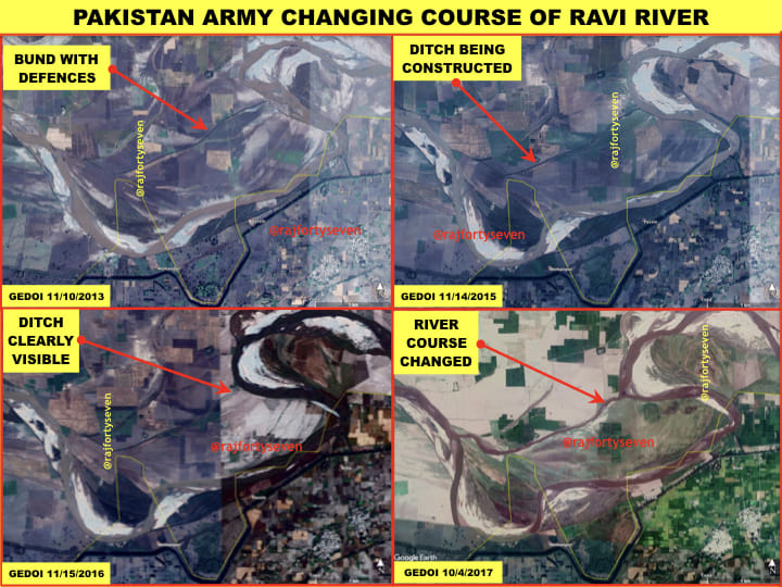
The river, which flows along the India-Pakistan international border, is now steadily diverted to run 600-1,000 metres inside Pakistan.
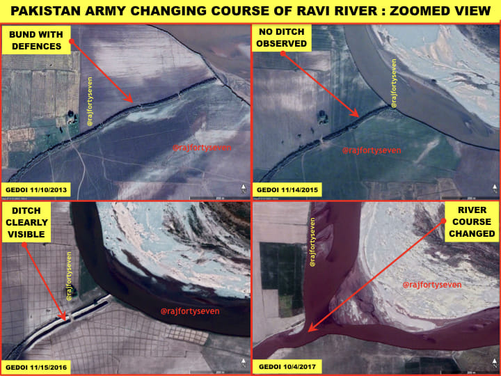
The move would deny any advantage of the river for Indian Punjab, as no water will be available for agricultural purposes once the river enters Pakistan.
Article VII 2 of the Indus Water Treaty between the two countries states that “if either party plans to construct any engineering work which would cause interference with the waters of any of the rivers and which, in its opinion, would affect the other party materially, it shall notify the other party of its plans and shall supply such data relating to the work as may be available and as would enable the other party to inform itself of the nature, magnitude and effect of the work.
“If a work would cause interference with the waters of any of the rivers but would not, in the opinion of the party planning it, affect the other party materially, nevertheless the party planning the work shall, on request, supply the other party with such data regarding the nature, magnitude and effect, if any, of the work as may be available.”
However, highly-placed sources in India’s union ministry of water resources, river development & Ganga rejuvenation told ThePrint that the minor diversions on the Ravi are “not of much concern”.
“Any river gets minor diversions in the natural course too. However, in case of India and Pakistan, both the countries sometimes carry out flood protection work on the rivers and build bunds which can cause some diversion, but that is allowed in the Indus Water Treaty of 1960,” a senior government official said.
“However, such diversions on the Ravi usually divert the river towards India. So, it is highly unlikely that the entire course of the river can be diverted to completely deny water to India.”
Sources said that in earlier meetings, the issue had come up for discussion between the two countries, but was not pursued thereafter.
“Satellite images of Ravi show that it criss-crosses the border at 16-17 points. Bunds are made at certain points for flood prevention work,” the official said.
“However, if the Punjab government brings to the notice of the Indus Water Commission any major diversions which have led to material damage or were for consumptive use, it can be taken up,” the official said.
(With inputs from Amrita Nayak Dutta)




In my opinion, the public have come to perceive the reason to dump HAL despite the fact they possess 70 years of experience in the field. No amount of explanation by any socalled experts would convince them.
I dread to think about a situation where defence is in the hands of Congress. They will put the clock back. And sell the nation to our opponents .Let us pray.
Good for the PAK Army. I hope the Indian Army is also bolstering their defence and offensive measures in light of these defensive upgrades on the Pakistan side.
This col is a black spot in Indian Army. r u fool, as a military officer one should know how difficult it is. seems to be either an agent of ISI, because there is nothing as such on ground, but i think he is providing information to ISI and Pakistan Army to do so in future. He should return the title to Indian Govt. don’t know the ABC of warfare even.