


New Delhi: A US-imposed naval blockade of Iranian ports has been in effect since 13 April, meaning that any inbound and outgoing traffic from Iran will be blocked by US forces stationed in and around the Persian Gulf and Gulf of Oman.
Iran has at least 13 major ports, 11 of which are in the Persian Gulf or the Gulf of Oman, which are potentially impacted by the blockade.
In March 2025, Iran’s ports handled a total of 234.8 million tons of goods, Saeed Rasouli, Deputy Minister of Transport and Acting Head of the Ports and Maritime Organisation had said last year. “In total, 82.3 million tons were unloaded, and 152.5 million tons were loaded at the country’s northern and southern ports. Oil products accounted for 103 million tons of the total, while non-oil goods made up nearly 131.8 million tons.”
Iran’s economy is heavily reliant on oil exports. In March this year, Iran exported nearly 57.9 million barrels, according to market intelligence firm Kpler.
Additionally, Tehran exports petrochemicals, as well as foodstuffs such as nuts. According to the Observatory of Economic Complexity (OEC), in 2024, the majority of Iran’s imports included soybean meal, soybeans, corn, motor vehicles, accessories and rice.
After years of crippling sanctions and a collapsing currency, the current conflict between the US, Israel and Iran has left the Iranian economy in shambles. Most recently, the Iranian rial hit 1.58 million to a US dollar. Inflation remains high in the West Asian nation. Its oil exports remained a lifeline during the conflict, as the US waived sanctions on Iranian oil already at sea for a period of 30 days to stabilise global markets.
ThePrint lists the major vulnerable ports which will be affected by the American blockade aimed at squeezing the economy to force Tehran into negotiations.
Also Read: How Iran choked Strait of Hormuz & why it’s not easy to break the blockade
Kharg Island
Kharg Island, long described as a “forbidden island” due to restricted access and tight military control over the premises by the Islamic Revolutionary Guard Corps (IRGC), handles 90 percent of Iranian oil exports.
The island is nearly 25 km from the coast of mainland Iran, and is about 8 km long and 4-5 km wide.
With a storage capacity of 30 million barrels of crude, the island also acts as a strategic deep-water terminal.
The terminal at the island can accommodate nearly 10 Very Large Crude Carriers (VLCCs) and has a throughput capacity of 7 million barrels of oil per day. Throughput capacity refers to the amount of oil that can be received, handled, and exported daily.
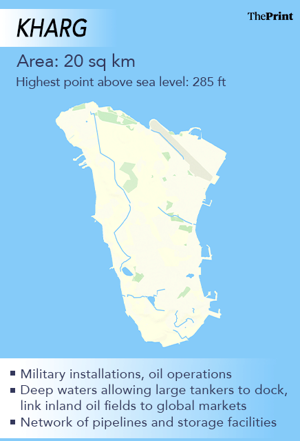
With two major terminals, including Eastern Harbor (Tee-Jetty) and the Western Dock (Sea Island), the island is considered the heart of Iran’s oil exports.
During the current conflict—now in its seventh week—US President Donald Trump had threatened to target the island’s oil infrastructure if Tehran did not allow the transit of ships to resume through the Strait of Hormuz.
During the Iran-Iraq War (1980–88), Kharg Island was also targeted by the Iraqi forces, which temporarily damaged the oil terminal. However, to accommodate the supplies of energy, Tehran shifted its shipping of energy to smaller facilities at Lavan and Sirri islands.
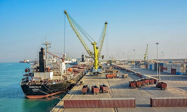
Port of Shahid Rajaee
As part of Bandar Abbas in Iran’s southern Hormozgan province, Shahid Rajaee is responsible for 85 percent of the total container loading and unloading carried out at the Iranian ports.
The geographical location of Shahid Rajaee is at the entrance of the Strait of Hormuz leading to the Persian Gulf. The port is also considered an important import and export gateway of Iran due to its short distance from the main intercontinental shipping route.
The port also lies on the International North-South Transport Corridor (INSTC), which aims to connect India with Russia, passing through the Indian Ocean and Persian Gulf to the Caspian Sea.
The port currently covers 4,800 hectares, which consists of 40 berths, including 10 container berths with depths of 13–17 metres. To quantify, the port has the capacity to handle Panamax ships up to 18,400 Twenty-foot Equivalent Units (TEUs) and 185,000 Deadweight Tons (DWT).
Chabahar Port
Chabahar Port lies at the mouth of the Gulf of Oman and is Iran’s first deep water port. The port lies to the west of Iran’s border with Pakistan, which is seen as a competition to Gwadar port, developed by China.
Chabahar consists of two separate ports, namely Shahid Kalantari and Shahid Beheshti, each with five berths. In 2003, India and Iran agreed to develop the Shahid Beheshti port, but threats of Washington’s sanctions led to a slowdown in New Delhi’s involvement in the Chabahar Port. Later, the talks were stalled.
However, in May 2016, India and Iran signed a bilateral agreement to refurbish one of the berths at Shahid Beheshti port and reconstruct a 600-meter-long container handling facility at the port. The deal was finalised in the backdrop of the Iran nuclear deal which was signed in 2015.
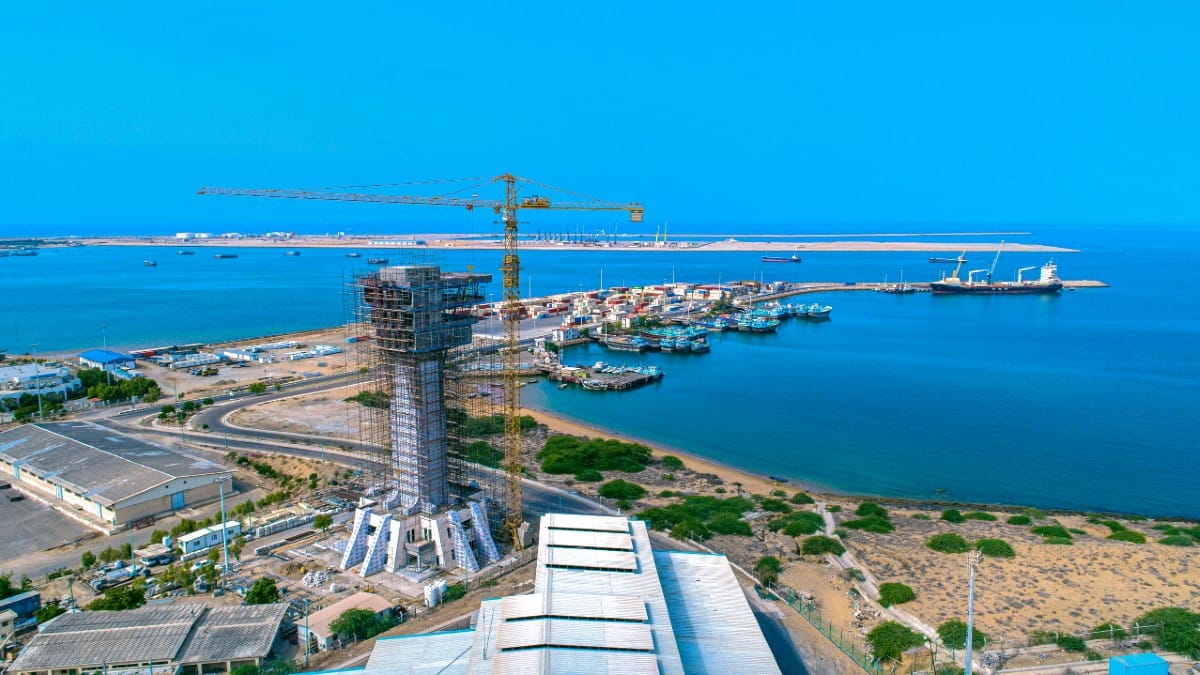
The port was seen as an alternative for trade between India and Afghanistan, as it was nearly 800 km closer to Pakistan’s Karachi port. For Afghanistan, Karachi port is a primary gateway as it grants duty-free access to Kabul under the Afghanistan-Pakistan Transit Trade Agreement (APTTA) 2010.
However, in January, India fulfilled its obligation by contributing $120 million for the Shahid Beheshti terminal as the final tranche was transferred in August 2025.
The Trump administration earlier revoked a long‑standing Afghanistan-linked sanctions exception in September 2025, but issued a six‑month conditional waiver from late October 2025 to 26 April 2026, under which India Ports Global Limited (IPGL) can continue operating the terminal.
Port of Jask
Located outside the Strait of Hormuz, the Port of Jask is a strategic seaport, which is on Iran’s Marakan coast. The port handles crude oil, general cargo, and the proposed end for the Goreh-Jask crude oil pipeline.
The pipeline allows the flow of roughly 300,000 barrels of oil per day and is envisioned by Tehran as an alternative route to its existing facilities, which are primarily located in the Strait of Hormuz. It could eventually allow almost one million barrels of oil per day to reach the port of Jask, bypassing the strait.
In 2019, the Iranian authority constructed a new oil tanker terminal with a total investment of $700 million. The project was followed by further construction of the refinery and petrochemical plant.
Following the threats on the Kharg Island, the Port of Jask has emerged as an alternative for energy exports. The terminal is designed to have a capacity of 1 million barrels per day.
Imam Khomeini Port
Situated in the Bandar-e Emam Khomeyni District of Khuzestan province, Imam Khomeini Port lies in the downstream of the Ghazaieh River, which is about 45 nautical miles away from the north side of the Persian Gulf.
The port covers a total area of 1,041 hectares, which facilitates the handling of bulk cargo, essential goods, and petrochemical products. The port primarily imports grains, iron ore, and industrial materials.
Annually, the total of 16.4 million tons of cargo, 40,250 TEU, and 6,200 passengers are handled by the port. The maximum draught and deadweight of the port are 13.7 meters and 93,291 tons, respectively.
Bushehr Port
This port lies at the heart of the Central District of Bushehr County, Bushehr province, Iran. Covering an area of nearly 550 hectares, the port contains 14 berths.
According to the Bushehr Port Special Economic Zone, the port is considered the third-largest port in terms of overall performance. The port also accounts for 11 per cent in terms of container share in Iranian ports, which is the second highest after the Shahid Rajaee port.
The city of Bushehr is also home to Iran’s only operational commercial nuclear power plant. Constructed in 1975 by Germany’s Kraftwerk Union (Siemens), the construction work was halted after the Islamic Revolution in 1979. However, the plant was completed by Russia’s Atomstroyexport.
During the conflict with Israel and the US, the plant was damaged by a projectile. IAEA also confirmed that the strike landed within 75 m of the Bushehr Nuclear Power Plant. However, the reactors were not damaged.
Bandar Taheri Port
Located in the ancient port city of Bandar Siraf, Bandar Taheri specialises in carrying SBM (Single Buoy Mooring), which is capable of handling tankers up to 40,000 DWT.
The port operates in the tropical zone on the Persian Gulf with a maximum depth of approximately 22 meters at low water, which is often used for liquid cargo.
During the Sassanid and pre-Islamic period, the port was a bustling trade hub that served as a major maritime silk road, connecting India, China, and Africa. However, in 970CE, several episodes of massive earthquakes and tsunamis damaged and drowned much of the port city.
(Edited by Nardeep Singh Dahiya)
Also Read: When geography is a weapon: How Iran is using 7 islands to keep a chokehold on Strait of Hormuz