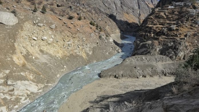
New Delhi: Heavy snowfall in the steep gorge in the Chamoli district may have triggered an avalanche, possibly disturbing loose debris that had been holding back a huge quantity of water, which then gushed forth, leaving destruction in its wake.
This is one of the theories put forth by D.P. Dobhal, an eminent glaciologist at the Wadia Institute of Himalayan Geology in Dehradun, to explain what caused an unexpected flash flood in Uttarakhand on 7 February.
Dobhal has been studying changes in the Himalayan glaciers for several decades. He was part of a committee set up by the Union environment ministry that studied the impact of hydroelectric plants on the 2013 Uttarakhand floods.
Ashutosh Sharma, Secretary, Department of Science and Technology, told ThePrint that a team of scientists from the Wadia Institute has moved to the area to conduct a detailed survey and understand the main cause of the disaster.
Initial reports suggest the flash flood was a result of a Glacial Lake Outburst Flood (GLOF). Glacial lakes are formed when glacial ice melts form lakes held together by loose debris. But when this debris is disturbed the water gushes out.
According to a statement by the Geological Survey of India, a total of 71 lakes of different sizes and types are reported in the upper reaches of Rishi Ganga and Dhauliganga valley.
However, several experts have so far pointed out that satellite images did not reveal any lakes in the area.
“There was heavy snowfall in the area that led to 3-4 feet high layer of snow accumulating in the area,” Dobhal told ThePrint. “Due to changes in the air, there was a snow avalanche. This avalanche may have disturbed some loose material that was holding a huge glacial lake.”
Dobhal said the quantity of water was very huge, and the flash flood culminated in just 10-15 minutes.
He said it is possible the water was hidden under the glacier, and held by some loose debris and ice at the edge of the glacier. Once this was disturbed, the trapped water was let loose.
“Another possibility is that an older avalanche or landslide may have blocked a part of a stream, causing water to accumulate in the area for some time. But as the mass of the accumulating water increased beyond a certain threshold, it breached the temporary block and suddenly a lot of water rushed forth through the gorge,” he said.
Nearly 200 people are missing while 20 are dead due to the floods, according to the government.
Also read: Four bodies recovered from hydropower plant site in Chamoli, over 50 still missing
If water was accumulating, why did scientists not spot it in time?
Dobhal said water getting accumulated in the area may not have been spotted because the area is not very accessible. “The route is very dangerous and cannot be easily approached,” he said.
“Whatever little is known about the area is based on remote sensing data. There are more than 14 glaciers in the area, of which South Nanda Devi and North Nanda Devi, are some of the largest glaciers in the area — which is almost 24 km long,” said Dobhal.
He added that even though the area was already a disaster in making, not many studies had been conducted of the glaciers in the area.
Dobhal pointed out that surveys of the glaciers should be conducted in areas where hydroelectric plants are being set up. Studies should be conducted in the areas to assess avalanche frequencies, size of glaciers, presence of sediments, and potential sources of water influx.
This not only helps anticipate the possibility of such disasters, but will also benefit the power plants. “It is also vital for the hydro project, because they need to know how much water will flow from the glaciers,” Dobhal said.
“For every developmental project there are positives and negatives. Himalayas are very fragile no doubt, but then we cannot stop the development,” he added. “If you delve into the data, there will definitely be solutions on how to prepare for such events.”
The on-ground team from the Wadia Institute would take at least a week to study the area. The team will look for geological signatures and clues to ascertain what really triggered the disaster.
Also read: ‘Company people said run or you’ll die’ — NTPC worker recalls fleeing Uttarakhand flood


This landslide does not seem to have anything to do with climate change . It was a slow geological process that led to rock slope failure on a steep slope hurtling onto the glacier below , the impact of the heat melting large amount of ice into water and eventually pushing this mix of water, rock and sediment into the narrow river gorge.
Accumulated water is a ticking bomb which gets released due to avalanche/landslide. Scientists must try to use technologies that discover huge volumes of water beneath glaciers.
It does not look like development of hydropower projects and roads are the cause of this. even without development of infrastructure such furies of nature cannot be avoided. We should focus more on monitoring for potential landslides/avalanches and large volume glacial lakes, early warning and prevention of such disasters.