


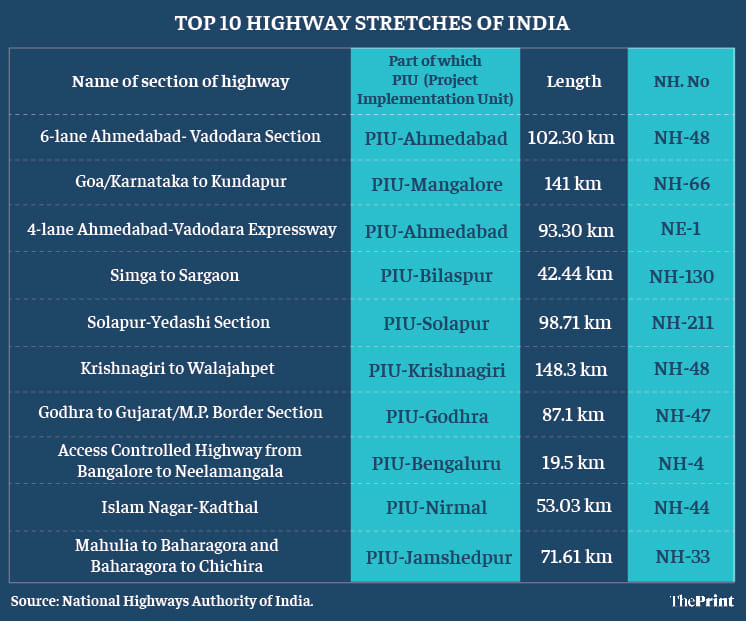
New Delhi: A 102-km stretch of the six-lane Ahmedabad-Vadodara section of National Highway (NH)-48, which connects Delhi to Chennai, is the best highway stretch in India in terms of efficiency, safety and user services, according to a rating done by the Union Road Transport and Highways Ministry and the National Highways Authority of India (NHAI).
The stretch got an overall score of 91.81 out of 100.
Although highway ratings are done frequently around the globe, this is the first time such an exercise has been conducted in India.
The 141-km stretch of Goa/Karnataka to Kundapur section of NH-66 connecting Mumbai to Kanyakumari has been rated the second best, followed by a 93.3-km stretch of Ahmedabad-Vadodara expressway, which is also called the National Expressway-1.
The Simga to Sargaon section of NH-130 was ranked the fourth.
All 219 national highway stretches across the country, covering a distance of 18,668 km, have been rated.
The objective of the ratings, road ministry officials said, is to identify interventions needed to improve efficiency and traveller experience on the corridor, in line with international best practices.
“The rating exercise of highway corridors will provide an assessment of current status of level of services on the national highway stretches. This exercise will help in identifying the gaps in design, standards, practices, guidelines and contract agreements. Filling those gaps will ensure improved user experience and improved quality of highways,” stated a report released Monday by Union Road Transport Minister Nitin Gadkari at a press conference.
The exercise will provide standards, which may be used for benchmarking of other highway corridors, stated the report.
At the release of the report, NHAI Chairman Sukhbir Singh Sandhu said national highways would be rated regularly from now on a 6-month basis to give time for their improvement.
NITI Aayog CEO Amitabh Kant, who was also consulted on the rankings, said at the press conference this would create pressure on contractors to ensure that their highway stretch was the best.
Also read: Rs 1 lakh crore Delhi-Mumbai and Ambala-Kotputli expressways to be ready by March 2022
Corridors assessed for the rating
For the purpose of the rating, the ministry chose four corridors, which included Agra-Mumbai (1,084 km), Pune-Vijayawada (856 km), Mumbai-Kolkata (1,927 km), Bangalore-Kanyakumari (655 km).
These corridors were selected as they connect the northern, southern, eastern and western parts of India, the report said.
Further, these stretches form part of the Golden Quadrilateral, North South-East West Corridor and they are of prime importance for freight and passenger movement throughout the country. Major parts of these sections have been developed under the National Highway Development Programme.
The parameters
The first-ever rating of highway stretches in the country focused on three parameters.
The first was ‘Highway Efficiency’ (45 marks), which comprised operating speed of traffic, traffic volume, delay at toll plazas, etc.
Second was ‘Highway Safety’ (35 marks), which comprised accidents on the highways per year, ambulance response time, road clearance after accident etc.
Thirdly, if the highway was ‘User Friendly’ (20 marks). This looked at the number of footpaths, junctions, adequate structures etc.
Worst performing stretches
The worst stretch was the 45-km Indore-Dewas section of NH-3, which connects Agra to Mumbai. This highway stretch got a ranking of only 36.96 out of 100, scoring poorly on all parameters.
The second worst was the 63.5-km section of the Delhi-Haryana Border to Rohtak on NH-10.
The third last was the 41-km Visakhapatnam to Anakapalli stretch of NH-16 that goes through the east coast of West Bengal, Odisha, Andhra Pradesh and Tamil Nadu.
Also read: 15 yrs in the making, Rs 9,000-cr Delhi-Gurugram expressway now looks at Sept 2022 completion
There is no representation from north-east India. Even from eastern India, Kolkata was the only city considered. The highway stretches are limited to north, west and south India.
Seems like step motherly treatment to east and northeast India.
Would be interesting to learn if elements like road surface quality (how often is it laid), cleanliness and environment (e.g. plants and trees planted), and digitalization (e.g. dynamic speed control) have been considered? If not, should definitely be considered going forward.