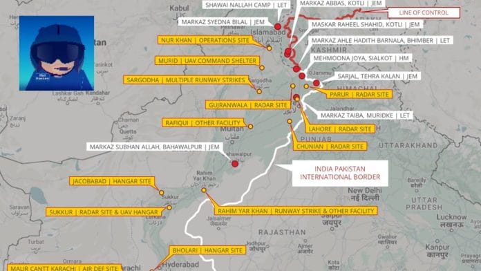
New Delhi: When armed hostilities erupted along the Line of Control (LoC) and International Border last week after India launched Operation Sindoor as retaliation for the deadly terror attack in Pahalgam, the battle was waged not just with drones, jets, and artillery. Another front emerged almost immediately: the digital battlefield.
Leading Pakistan’s charge was the Inter-Services Public Relations (ISPR), the military’s media wing, flooding social media with a torrent of dramatic claims and visual “proof” of damage inflicted on Indian airbases.
But amid the digital chaos, one figure stood out, vigilantly countering ISPR’s barrage of disinformation: Damien Symon, known to his thousands of followers on X as @detresfa_.
A geo-intelligence researcher at the AI-analysis firm The Intel Lab, Symon has spent years using publicly available satellite data and visual analysis to cut through the fog of war and verify, or debunk, claims made about conflict zones.
In the hours and days following the start of Operation Sindoor, Symon systematically dissected a wave of viral posts, allegedly showing Indian military losses. Most, he found, were not only false but in some cases, crudely manipulated.
“When disinformation spreads unchecked, especially from sources unconstrained by ethics, it can severely distort public perception in a rapidly evolving conflict. Each rebuttal is met with a narrative shift, forcing constant revalidation, while those pushing fake content face no such delay. They move faster than the systems designed to stop them,” Symon told ThePrint.
Also Read: Balakot, China ‘incursions’ prove OSINT images are new threat for democracies and military
Anatomy of a disinfo blitz
The ISPR’s response to Operation Sindoor followed a familiar pattern: dramatic images of bombed airbases, satellite snapshots of burning runways, and triumphant declarations of successful Pakistani strikes on Indian military installations.
One of the most widely circulated images claimed to show extensive damage at Jammu airport. But according to Symon, the image was not just manipulated, it was outdated.
“A doctored, manipulated image of Jammu Airport is being circulated to falsely imply damage on site,” he wrote on X. “However, recent visuals confirm no such destruction; in fact, the tampered image predates May 09–10.”
Even runway maintenance work at Udhampur airport, underway since April, was cited by some as evidence of bomb damage until Symon clarified that ongoing repairs had been misinterpreted.
Tools of truth
Symon’s arsenal isn’t secret: public satellite data from LANDSAT, high-resolution images from commercial providers like KawaSpace (India) and MazarVision (China), and rigorous visual comparisons with historical imagery. His findings, unlike many of the claims he counters, are consistently supported by verifiable visual evidence.
At Sargodha Airbase, Symon highlighted apparent craters on Runway 14/32 from Indian strikes. At Bholari Airbase, both Indian and Chinese commercial satellites confirmed the destruction of a hangar, with debris clearly visible.
At Jacobabad, imagery suggested a direct hit to a hangar on the base’s main apron, with suspected secondary damage to the air traffic control building.
At Nur Khan Airbase, satellite images captured burn scars on infrastructure and ground vehicles, although aircraft appeared untouched. Another one shows that there was no damage to Jammu or Udhampur airport.
Armed with satellite imagery, his latest tweet debunks claims no damage at India’s Adampur air base. “Another image circulating now claims to show damage at India’s Adampur Airbase due to Pakistan’s airstrike, however once reviewed against recent images this too has been doctored & manipulated,” he wrote on X.
OSINT and a race against disinformation
Symon attributes much of the disinformation to “sources unconstrained by ethics”—in his words, “random people on Twitter trying to spread fake news”.
But the stakes are anything but random, especially in a region as tense and heavily militarised as South Asia; even one viral image can inflame public sentiment and dangerously escalate an already fragile situation.
Open-Source Intelligence (OSINT) is enabling real-time verification using publicly available data. From exposing disinformation to documenting human rights abuses, OSINT is now a frontline tool against information warfare.
“OSINT plays a vital role in enabling real-time fact-checking through publicly available tools and data, bypassing the institutional delays that often hinder official responses. As the number of sensors and data sources grows, the open-source community gains more visibility and capability to monitor and respond swiftly,” Symon added.
(Edited by Sugita Katyal)
Also Read: Indian universities must teach OSINT to students. It’s the new intelligence currency


