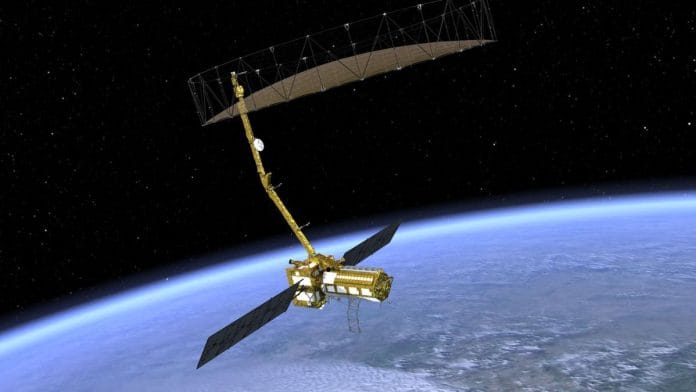
New Delhi: Eclipses will play spoilsport to NISAR, the ambitious low-Earth orbit (LEO) observatory mission that aims to monitor changing ecosystems, dynamic surfaces and ice masses. NISAR, which stands for NASA-ISRO Synthetic Aperture Radar (NISAR), was initially planned to be launched earlier this year. But now, it is expected to be ferried to space only after February 2025, senior officials from the Indian Space Research Organisation (ISRO) have confirmed.
SAR is a technique that uses a moving radar system to produce high-resolution images of Earth’s surface.
On Wednesday, Shantanu Bhatawdekar, scientific secretary, ISRO, told ThePrint on the sidelines of a press conference that the radar antenna reflector—a part of the NISAR satellite—had to be returned to the US for a special thermal coating in March. The reflector is expected to reach India by the first week of October.
However, the launch will not happen till February next year because of the solar eclipse period between November and January.
“NISAR is an incredibly complex, one-of-a-kind mission. Currently, the radar antenna reflector is with NASA for some correction and we are hoping that it will reach India by the first week of October. Since it requires a great amount of power, the launch cannot happen during the time of an eclipse. It might be scheduled for some time after February,” he said.
The launch will be conducted from India’s Satish Dhawan Space Centre in Sriharikota on board ISRO’s Geosynchronous Satellite Launch Vehicle Mark-II (GSLV Mk-II).
Also read: Scientists discover ‘dark oxygen’ produced on deep-ocean floor where the Sun don’t shine
What NISAR will do in space
NISAR is an LEO observatory being jointly developed by NASA and ISRO to map the entire globe in 12 days, while gathering spatially and temporally consistent data that will provide insights into Earth’s ecosystems, ice mass, vegetation biomass, sea level rise, groundwater and natural hazards including earthquakes, tsunamis, volcanoes and landslides, among others.
The satellite carries L and S dual-band SAR, which operates with the ‘SweepSAR’ technique to observe large swaths with high-resolution data. This is a novel technique, and NISAR will be the first to use it. The technique will cover a wide area and provide spatial resolution.
The spacecraft bus and the SAR payloads mounted on an integrated radar instrument structure (IRIS) are together known as the ‘observatory’. The mission profile also highlighted that NISAR uses a sophisticated information-processing technique known as synthetic aperture radar to produce extremely high-resolution images.
Radar penetrates clouds and darkness, enabling NISAR to collect data day and night in any weather, the mission document said. The instrument’s imaging swath—the width of the strip of data collected along the length of the orbit track—is greater than 150 miles (240 kilometres), which allows it to image the entire Earth in 12 days.
“By combining two kinds of synthetic aperture radars, it will offer measurements of Earth’s evolving surface—including changes in ice sheets and glaciers, wetlands and forests, and land around volcanoes and earthquake faults,” NISAR’s mission document read.
In an email response to ThePrint in April this year, NASA’s Jet Propulsion Laboratory (JPL) said that an addition of the special coating on the reflector was a precautionary step to mitigate any temperature increases that could potentially affect the deployment of the reflector.
“Testing and analysis identified a potential for the reflector to experience higher-than-previously-anticipated temperatures in its stowed configuration in flight,” the JPL said.
(Edited by Radifah Kabir)
Also read: Mars may have oceans’ worth of water underground, but this doesn’t mean it’s ready to be colonised


