


Bengaluru: Early morning fog, bone-chilling cold nights — as North India reels under one of its coldest December winters, there are fears it could get worse as the harshest period is just set to begin.
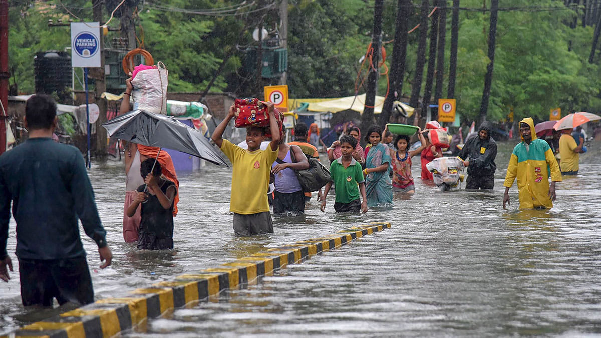
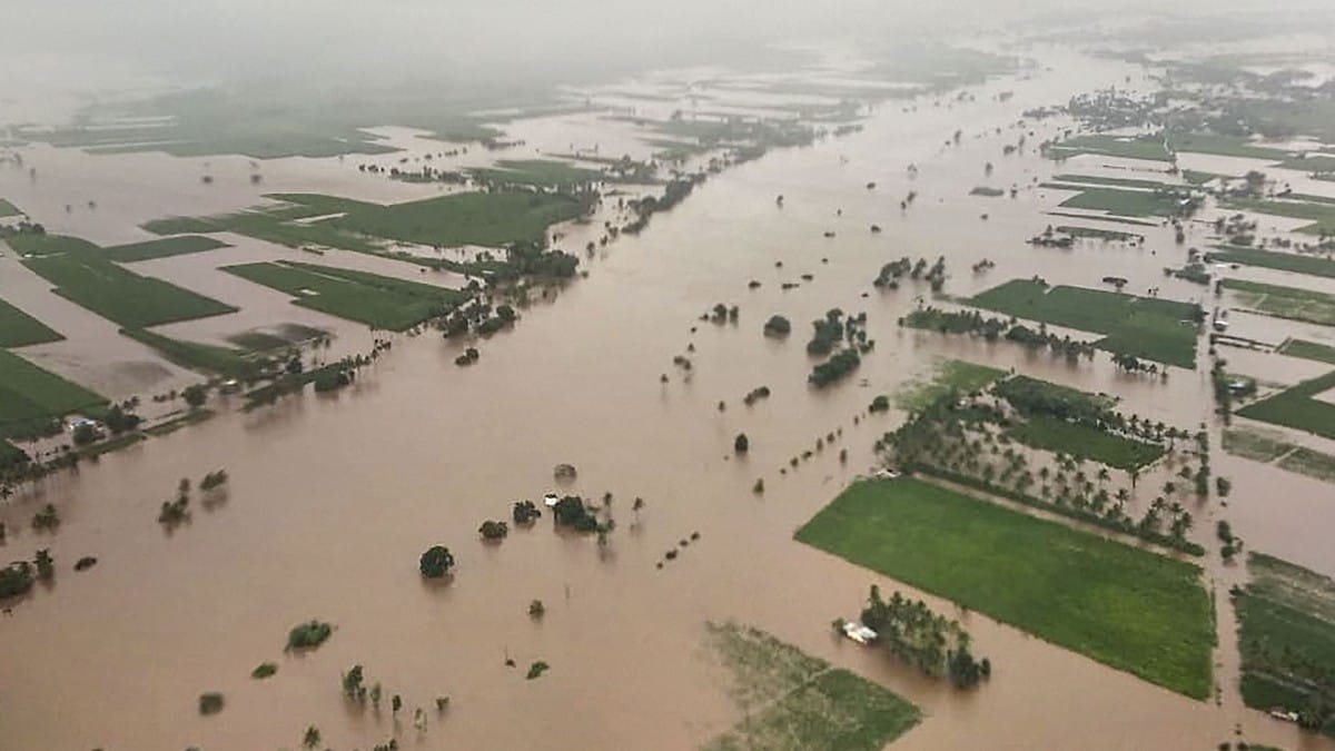
The winter was preceded by monsoon rains that devastated at least 13 states, including Bihar, UP, Maharashtra, Karnataka and Assam.
The two seasons, however, have a common thread running through them — awry predictions by the India Meteorological Department, the country’s apex weather forecasting body.
The IMD was so way off the mark on both occasions that the weather has been the extreme opposite of what it forecast.
In November this year, the IMD predicted a winter warmer than normal for Northern India, especially in the month of December.
But capital New Delhi is on course to have its worst winter in over 100 years while the rest of the region shivers.
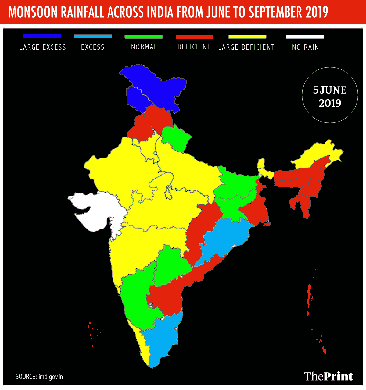
The IMD had also predicted a normal June-Sept monsoon thrice (on 15 April, 31 May, 1 August) with rainfall of 96 per cent of the Long Period Average (LPA).
Instead, the monsoon saw an excess rainfall of 110 per cent that caused floods in major cities such as Patna and was the highest-ever rainfall recorded in the country as a whole since 1994.
This is in line with consistent weather forecasts that have been inaccurate when it comes to temperatures, droughts, heat waves, cold waves, and most importantly, the monsoon.
They, however, aren’t an anomaly. Getting the weather wrong time and again isn’t unheard of, even in other nations. And it comes down to the basics — how weather is modelled and how much we understand it.
Short-term weather forecast
There are traditionally three types of forecasts: a short-term weather forecast for up to a week to 10 days including daily temperatures and time periods for rainfall; seasonal forecast for a period of 60 to 90 days including the amount of rainfall to be received in that period; and a long-term forecast that deals with climate changes in time periods of 30 to 40 years in the future.
Of late, there is also a fourth: decadal forecast for a period of 10 years.
What creates inaccuracies in short-term weather modelling is input data or, what are called, initial conditions.
For short-term weather forecasting, scientists collect data from sensors and weather stations across the country, which transmit information about local temperature, precipitation, humidity, wind speed, its direction, atmospheric pressure and more. The information is captured every 6 to 12 hours, and then fed into a weather model.
The model then extrapolates the data and churns out a forecast. It also takes into consideration the discrepancy between previously predicted forecasts for the day or week and situation on the ground. It then fixes those gaps for future data in a process called verification.
IMD uses a dynamical model developed in the US called the Weather Research and Forecasting (WRF) Model, which assimilates data and processes it at the same time.
The IMD model adapts this by uploading Indian data and calibrating it for an Indian setting. They have been uploaded on the Prithvi High Performance Computers (HPC) at the Indian Institute of Tropical Meteorology (IITM), Pune.
The model initially extrapolates this captured data to form a grid-structure. It then crunches numbers based on the algorithm and then churns out a short-term weather forecast for the grid.
There are other institutes that work on modelling too, including the National Centre for Medium Range Weather Forecasting (NCMRWF) and IITM-Pune itself. These institutes have highly accurate local weather forecasts and extreme event prediction, like cloud bursts (localised extreme rainfall or storms).
The system, however, isn’t always perfect.
Also read: ‘State of planetary emergency’: Global climate tipping points seen in fresh warning
The lack of infrastructure
The IMD does fairly well in forecasting weather for five to seven days but in some locations, the numbers can be quite off.
The data for all the models come from IMD sensors, and the problem is that there aren’t enough.
Take for instance the Himalayas, a major part of the country when it comes to weather prediction.
There is a very sparse network of weather stations here, some as far away as 80 to 90 km from each other. There are a mere 77 stations spanning the union territory of Jammu and Kashmir and the states of Himachal Pradesh and Uttarakhand.
Even in the rest of the country, where there are about 8,000 stations, several are non-functional, recording zero values, including some having broken doppler radars.
“Because of the complex topography of the Himalayan region, there are some serious challenges in short-term prediction,” said Sarita Azad, assistant professor at IIT-Mandi who works on the Indian monsoon and related extreme events.
“In the Himalayas, more reliable data is required as the entire region is subjected to extreme events like cloudbursts,” she added.
Azad’s ongoing research, where she and her students have analysed 18 cloudburst events in the region in recent years, revealed that there were weather stations near only six of the locations. With such a data deficit, models cannot be calibrated accurately.
Azad further states that the interpolation to grid is too basic. While it works well for plain surfaces, it fails to take into consideration varying terrain between stations, including change in altitude in places like the Himalayas.
It isn’t just lack of infrastructure but if scientists are to be believed there are is a lack of co-ordination between agencies tracking the weather.
“Institutes like ours are in a position to provide sensors and weather stations to capture and collect data ,” Azad said, adding IMD could make use of them if it chose to.
“American chief climate agencies like NOAA and NCAR have expressed keen interest in collaborating with IIT Mandi to understand the important Himalayan region better, and such collaborations will surely bear fruits in the near future and will be a contribution for the region,” Azad said.
Having said that, short-term weather predictions are usually more accurate in the central and southern Indian states, which have a dense network of sensors, owing to the agricultural dependence on monsoons.
The resolution of forecasts is also a factor in determining accuracy. IMD forecasting typically generates predictions with a resolution of 12 km, meaning that the system claims to be sensitive enough to offer differences in forecast for regions separated by 12 km.
That could, however, change in the future.
Computer giant IBM plans to build a higher-resolution forecast model working with a sensitivity of 3 km. Called IBM Global high-resolution Atmospheric Forecasting System (GRAF), it will rely on user-generated data through a mobile app. The data is expected to be collected every three hours and forecast churned out over multiple time-frames such as three days, weekly or fortnightly.
‘IMD gets it right qualitatively’
Mrutunjaya Mohapatra, the recently-appointed director general of IMD, says the difficulty in forecasting in India is due to the nature of the weather in the country.
“Unlike countries such as the US and UK, weather in tropical countries like India is like an undisciplined child,” said Mohapatra, who is hailed as the ‘Cyclone Man of India’ for his team’s work at the Cyclone Warning Division of the IMD in correctly predicting cyclones over the last decade.
But a country that has a monsoon-dependent agricultural system cannot afford to keep getting its monsoon forecast wrong.
Mohapatra, however, says qualitatively, IMD predicted the monsoon trends correctly, even though it could not quantitatively predict how much excess rainfall the country would get in August and September this year.
“If you look at the statement issued in April/May, we said that weak El Nino condition is prevalent and it is likely to become weaker, and will approach neutral condition in the second half,” Mohapatra told ThePrint. “Based on this, we said June will be deficient, and then rainfall will gradually increase. And the second half will have better conditions.”
“What actually happened is that June became deficient, July was normal, August was excess, September was large excess. Which means that qualitatively what we predicted occurred,” he added. “But I agree, we could not predict quantitatively the excess rainfall in August and September.”
Scientists at the Indian Institute of Science, Bengaluru, and the Indian National Center for Ocean Information Services (INCOIS), Hyderabad, had, however, published a report in September in the journal Current Science, which predicted “above normal” monsoon rains in August and September due to the diminished effect of the El Nino, along with the development of the Equatorial Indian Ocean Oscillation (EQUINOO).
This report was based on observations made on 10 August.
The IMD claims while it can predict the large scale parameters that affect seasonal monsoons, like El Nino, it still struggles with variations within a season, such as development of low pressure regions that drastically affect the monsoon.
‘Getting weather right during season difficult across the globe’
Other scientists too say predicting weather within a season is a difficult task not only in India but across the globe.
“We are capable of predicting only short-term weather accurately across the world,” said Govindasamy Bala, professor at the Centre for Atmospheric and Oceanic Sciences at IISC. “There is uniform accuracy across the world in predicting the weather for five to 10 days. We are also good at predicting long-term climate such as 30 to 40 years into the future. But for time periods in the middle, as a scientist, I can tell you that there is very little prediction skill for seasonal forecasts.”
For seasonal forecasts, the concept of internal variability plays a role. As there are so many parameters that cannot be controlled and understood, the chaotic nature of the extremely complex system makes it hard to predict how each of them will swing on their own.
This is despite the fact that IMD makes use of two kinds of modelling mechanisms. One is the statistical model that uses datasets of over 100 years to find correlations in weather patterns, such as whether there is a positive trend in sea surface temperatures.
A new dynamical model, developed by IITM-Pune as a part of Rs 1200-crore Monsoon Mission is also used. This model, built on top of the American Climate Forecast System (CFS), is a coupled ocean-atmosphere modelling system that takes in data from land, sea, and air for long-range seasonal forecasting.
“There is no theoretical basis for improving accuracy with our current understanding of the weather and climate,” explained Bala. “It is still a very active area of research: Is there predictability, and if there is, how can it be improved?”
Just like in India, it is a dilemma across the globe. Sometimes, seasonal forecasts are largely accurate while at times they are a complete miss.
One of the major problems is that the underlying math behind climate modelling — numerical analysis — is a method of approximations. This means that a probability of errors is inherent in the methods used to model climate. These errors can be reduced by increasing the number of points from where observations are taken but they cannot be completely eliminated.
At the same time, scientists hope to find a hidden clue that seems to be just out of grasp. Among all the various parameters, there is sure to be one or some that plays a large role in controlling seasonal weather, they think.
“If we manage to locate the right parameter and see how it behaves, we could possibly get new information,” said Bala.
Multiple uncertain global parameters
Meteorologists and weather scientists are looking for patterns similar to the Eurasian snow cover, for example, which can hold a cause-and-effect relationship with seasonal weather. It is generally thought that if there’s a high amount of springtime snow in Eurasia, the monsoon is weaker in the summer.
But this doesn’t always hold true and can’t be taken as a rigid indicator. There are other such patterns or phenomena whose understanding, when improved, could also improve seasonal forecasting.
Some phenomena the Indian monsoon depends on which we haven’t managed yet to fully understand or predict include the formation and evolution of El Nino Southern Oscillation (ENSO), where sea surface temperatures in the tropical Pacific Ocean rise to high levels for an extended period of time and then fall for long periods.
Another is the Indian Ocean Dipole (IOD) where the Arabian Sea becomes alternately warmer and cooler than the Bay of Bengal.
A further phenomena is the Atlantic Zonal Mode (AZM) that has an inverse relationship with the Indian monsoon’s intensity. Other factors include the Atlantic Ocean’s temperature, the sudden development of low pressure regions over Indian Ocean, and clouds, which are notoriously difficult to model.
Clouds that form as a result of the convective process, which causes hot air to rise, are one of the major factors behind India’s weather predictions going wrong.
This year’s excess rainfall is thought to have occurred due to either the IOD or the lack of weakening of El Nino or both, while the excessively cold winter likely occurred due to the Western Disturbance (WD), storms originating in the Mediterranean that bring excessive rainfall or snow to the Himalayas.
“There is some variable in these or other similar phenomena that affects seasonal rainfall in a specific way, but science hasn’t managed to locate it yet,” Bala said. “If forecasting agencies can currently predict seasonal weather consistently accurately, I’ll be very surprised.”
Cyclone prediction: A success story
One of the areas that the IMD has earned credit is in the prediction of cyclones.
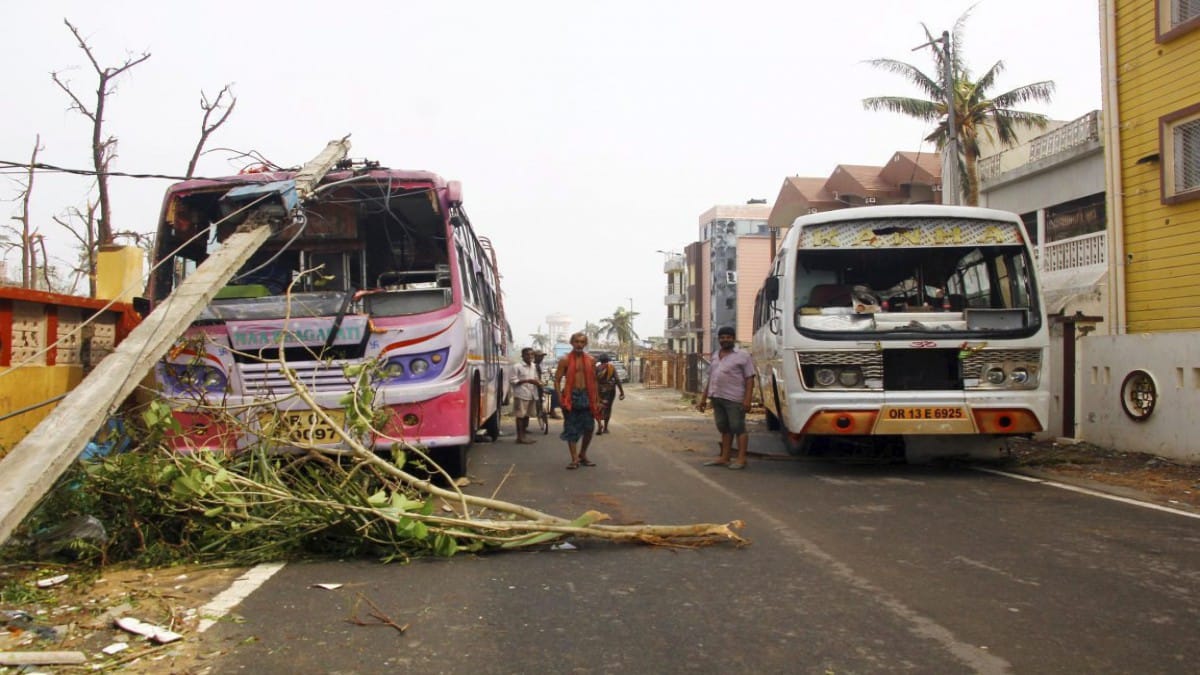
The 1998 Gujarat Cyclone and 1999 Odisha Cyclone resulted in the loss of tens of thousands of lives, and widespread damage to infrastructure and property. The losses prompted the government to modernise the IMD as well as set up the Ministry of Earth Sciences in 2006.
Mohapatra recalls that most of the work related to weather prediction in those days was done manually, and communication systems were very slow.
“It took 18 hours to make a prediction. By that time the cyclone would have moved and completely changed course,” he explained. “Data was plotted by hand and would come through teleprinters. Telegrams would take six hours to reach. Then someone would write the bulletin by hand.”
“By the time the prediction was made and public informed, the event had already occurred,” he added.
Back then, IMD only had one satellite that sent imagery every three hours. There wasn’t doppler radar and the analogue radars provided only pictures of the clouds but not the wind distribution or rainfall within them.
“We did not have automated weather stations or buoys,” recalled Mohapatra.
“Now we have seven computer models running twice and a robust observational network of 20 buoys, 30 ships, and over 700 automated weather stations,” he said. “There has been a paradigm shift in all aspects of forecasting, from observations, modelling, forecasting, and dissemination.”
India’s cyclone preparedness ahead of Cyclone Fani recently earned worldwide praise as IMD’s accurate impact forecast enabled authorities to ensure early evacuation of millions of people.
Upcoming plans
The Ministry of Earth Sciences plans to develop a ‘Centre of Excellence’ by 2024 to address the needs of the North Western Himalayan region.
A major augmentation of the observational network in the region has been envisaged, according to a statement by the ministry.
Mohapatra said the vision for the coming five years is to strengthen the observational network as well as make improvements to how forecast information is disseminated. Improvements are required in many areas, such as with thunderstorm predictions, which require radar observations at the scale of every kilometer.
“The entire country is not covered by radar, so we are planning to have a total of 62 radar systems in the next five years,” Mohapatra said. “We also need more R&D into understanding these weather processes.”
“The overall computing capacity also needs to improve,” he added. “Currently, we have eight petaflops capacity. Our plan is to upgrade to 100 in the next five years.”
IMD is also planning to launch a mobile app for better dissemination of ‘nowcast’ — very short term, localised weather predictions just three to four hours in advance.
Tying into all of this is also the pressing problem of pollution that asphyxiates all of Northern India on a regular basis every year.
Experts have been calling for a dynamic action plan in response to the prediction system at System of Air Quality and Weather Forecasting And Research (SAFAR) at IITM. However, the system’s forecasts are dependent on IMD’s modelling.
“All the weather-related input data comes from the IMD, but the information related to air quality is collected by SAFAR,” said Gufran Beig, Project Director of SAFAR.
As pollution becomes an increasing threat to health and life in the country, the urgency for IMD to revamp itself yet again becomes even more imperative and urgent.
Also read: Climate change in focus as record-breaking tide floods Venice
Actually its easy prediction … Just prepare for opposite of what IMD predicts 😀 !!!
Sandhya sure you went to college ? any duffer know non season rains does not warn like when husband comes and and trashe you or other way round so don’t waste asking such dumbo questions