


If Helen’s is the face that launched a thousand ships and started the Trojan War, NJ 9842 is the map grid reference point which launched a thousand soldiers and started the coldest war – a military standoff which continues at the highest battlefield on Earth in the environs of the Siachen glacier, which is ensconced between the mighty peaks of the Saltoro Range and the Eastern Karakorams.
But what is NJ 9842? Where is it mentioned? Was it envisaged as the terminal point of the ceasefire line of 1949?? Where is it physically located? What is the exact meaning of the term? What are the misconceptions surrounding it?
What is NJ 9842?
India and Pakistan fought their first war over Jammu and Kashmir in 1947 and it ended with a cease fire coming into effect on 1 January 1949. Thereafter talks commenced to delimit, demarcate and delineate a cease fire line (CFL) and on 27 July 1949, the cease fire agreement (CFA) was signed in Karachi. The CFA is a delimitation agreement which gives the alignment and orientation of the CFL between two specified extremities, Manawar and the ‘glaciers’. Towards its northern end the line is described as running from Chalunka (on the Shyok River), Khor, thence north to the glaciers. This portion of the cease fire line was to be demarcated in detail on the basis of the factual position as of 27 July 1949 by the local Commanders, assisted by the United Nations Military Observers.
Immediately thereafter, on 29 July 1949, directives were issued to the United Nations Military Observers by Lt. Gen. Delvoie regarding the procedure to be followed for the detailed demarcation and delineation of the CFL on a one inch map. On 8 August, the Sector Chart for demarcation in eight sectors was shared with the eighth sector being Marpola NN 6744 incl. Glacier. In this sector Maj. Gen. Crum, Captain Frederickson and Major Ward were the UN Observers from the Pakistani side (Location: Marol) while Major Ives, Col. Ebbesen and Major Kaufmann were the UN Observers from the Indian side (Location: Kargil). The process which commenced in the first week of August was expected to be completed within a month. However it continued till much later, as a result of which, the one month period provided in the CFA for readjustment of troop positions had to be extended to 31 October 1949. By September 1949, the first snow had already fallen in a few of the high mountain passes and the task of undertaking physical demarcation of the line in the heights was yet to be completed.
Since the entire Jammu and Kashmir dispute was expected to be resolved within a few months, and there was neither any controversy inter-se regarding the orientation of the CFL till the glaciers nor any misconception regarding the language of the CFA, one can assume that both sides reasonably concluded that physical demarcation in such hostile terrain could be left for a future date as there was a distinct possibility that it might not even be necessary. Additionally the limited resources, harsh climate, general inaccessibility of this uninhabited and glaciated region coupled with the fact that it had never witnessed any skirmish would have been relevant factors weighing on both sides’ when they decided to halt the process well short of the glaciers, contrary to the mandate of the delimitation document.
The northernmost point up to which the CFL was mutually delineated and demarcated is identified by its map grid reference and referred to as NJ 9842 or NJ 980420. The region between this point and the glaciers was pending mutual demarcation and delineation under the supervision of UN Observers.
Also read: How an American woman mapped the world’s highest battleground—Siachen Glacier
How did NJ 9842 emerge?
NJ 9842 is not mentioned anywhere in the CFA executed on 27 July 1949 and emerges only in the description documents which came into existence during its detailed demarcation and delineation. The document titled Description of the cease fire line as drawn on the Official Map No 1: Para X from Point NN 675740 to NJ 9842 (Map Sheets ¼ inch No: 43N, 52B, 52F) describes the CFL as it runs from Marpo La till NJ 9842. Towards the end, this document reads as follows:
– Thence East across the INDUS river to river Nullah Junction at NJ 266005
– Thence Eastwards up the Nullah up to NJ 300010
– Thence ENE on an 86 magnetic bearing in a straight line to SHANGRUTI point 17531 at NJ 399046, which line is marked by four stone cairns.
– Thence NE in a straight line to the boundary line at NJ 436060
– Thence starting northwards along the boundary line to CHORBAT LA at NJ 586078 which point is marked by a stone cairn on the top of the pass.
– Thence Eastwards along the boundary line up to NJ 770015
– Thence SE to the Nullah source and thence down the Nullah to the Nullah junction on the TEBE LUNG PA at NJ 910033
– Thence following the TEBE LUNG PA to Nullah junction at NJ 918086
– Thence northwards keeping approximately five hundred yards east along the Eastern Bank of the TEBE LUNGPA to a high feature 500 yards east of the Junction of the TEBE LUNGPA and the SHYOK river at NJ 962140
– Thence across the SHYOK River, to cairn at NJ 959145,
– Thence up the ridge to a point on the boundary line at NJ 975193
– Thence northwards along the boundary line going through point 18402 up to NJ 9842.
Was NJ 9842 envisaged as the terminal point of the CFL in the CFA?
Several grid reference points have been mentioned in the CFA but there is no reference to NJ 9842. This makes it evident that this point was not even in contemplation on 27 July 1949 when the delimitation agreement was executed. If the CFL was meant to terminate at it then its description would have read KHOR thence north to NJ 9842 and not KHOR thence north to the glaciers. If the CFL was meant to terminate at KHOR then the words ‘thence north to the glaciers’ become superfluous. Therefore it is evident that the CFL envisaged in the CFA was meant to terminate at the glaciers and not NJ 9842.
Without any evidence, it would not be proper to assume in hindsight that all these points including NJ 9842 were randomly selected by the Military Commanders of both sides’ simply for convenience or otherwise without appreciating the ground position while chalking out the final position of the line. However Lt. Gen. V K Raghvan asserts that, “the map point NJ 9842 was chosen by the military negotiators as the terminus of the line for convenience since it formed an easily identifiable point in the corner of a map square which was closest to the presence of troops in the north when fighting ended in 1948”. If indeed NJ 9842 was chosen as the ‘terminus’ of the line like this, then nothing prevented the negotiators from mentioning it in the CFA. Furthermore, if ease of identification was a concern, then things would have been much simpler if the line had been extended at-least on the map, all the way north till the glaciers in compliance with the CFA or the known boundary of the State, as a point on the boundary would have been far easier to identify than a point hanging in the air.
Where is NJ 9842 located?
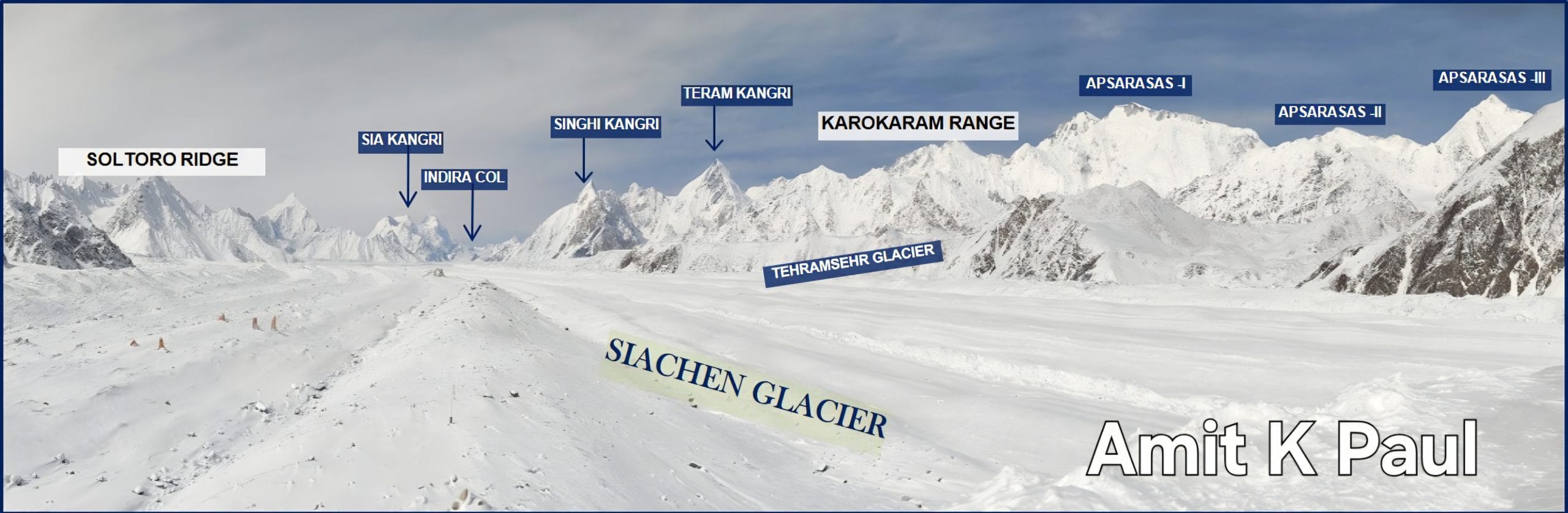
There has been much confusion and speculation about the location as well as nature of NJ 9842 and whether it is an area or a point. Contrary to what some commentators have written, it does not lie close to the Shyok River in the Shyok valley or at the foot of the Saltoro range or at the edge of the Siachen Glacier. It lies en route to the glaciers from Chalunka and to the north of Chalunka and the KHOR heights, which originate in the Shyok valley. Located on the Chulung heights in the southern end of the Saltoro Range, it is near Chulung La. Its western neighbor is the Chulung glacier, south western neighbor the Korisa Glacier (source of the Chalunka Lungpa stream which flows into the Shyok) and south eastern neighbors, the Urdolep and Thusa glaciers. In his 2012 work ‘Ladakh: Changing, Yet Unchanged’, Romesh Bhattacharji positions NJ9842 below the Chulung La specifically near the South portion of the Chulung glacier from where it wends its way to Chulung La. Identified on a height in Sub Sector West of the Indian Union Territory of Ladakh, it lies well within the area controlled by the Indian armed forces. Only accessible by foot, the Indian Army unfurls the National flag on it on 15th August every year.
Also read: Hodgson’s Line—US map decision that fuelled Pakistan’s Siachen claim even after correction
Was there a shift in the terminus of the line to NJ 9842 in 1972?
Many commentators have opined that there was a shift in the northern extremity of the CFL of 1949 to NJ 9842 in 1972 when the Line of Control (LoC) came into existence. However this is incorrect. Even during the demarcation and delineation of the LoC which emerged after the Suchetgarh Agreement of 11 December 1972, the entire focus was on areas where there were disagreements and hostilities. Since the region beyond NJ 9842 did not have any military presence and had not seen any action neither side contemplated that it would become a bone of contention in the future. It appears that both sides were happy with the status quo in the region in terms of the ground position (area being unoccupied and demilitarized) as well as the paper position enunciated in the CFA (area pending mutual demarcation and delineation) therefore neither raised any claim to it. Consequently no effort was made to demarcate the line beyond NJ 9842.
The document titled, ‘Description of the Line of Control as drawn on map sheets no. 52B, 52F and 52E’ gives a detailed description of the final journey of the LoC from Point 260955 on Map Sheet 52 B/6 to NJ 980420 on Map Sheet 52E (Annexure 19 of the Suchetgarh Agreement). Signed by Major General Rajwade from India and Brigadier Abbasi from Pakistan, towards the end it describes the LoC as: “thence northwards to NJ 737313 on Pakistan map and 737315 on Indian map, a point in the mid-stream of River Shyok , thence eastwards along the mid-stream of River Shyok to NJ 753308, thence NE to NJ 776329, thence eastwards following the spur to NJ 790334, thence ENE along the same spur to NJ 800343, thence eastwards to NJ 837354, thence northwards to NJ 844380, thence SE to a point on the boundary at NJ 973330, thence along the boundary line to NJ 980420”.
This description shows that the northern terminus of the LoC is the same as the northernmost demarcated point of the CFL i.e NJ 9842. Though the point remains the same, the crucial difference is, while it is the formal terminus of the LoC agreed in the Suchetgarh Agreement, it is not the formal terminus of the CFL agreed in the CFA, which continues to be the ‘glaciers.’ Since the LoC terminates at NJ 9842 therefore the line held by India from this point till Indira Col along the crest of the Saltoro Range is referred to as the AGPL or the actual ground position line.
What does NJ 9842 mean?
NJ 9842 or NJ 980420 refers to the same specific map grid reference point according to the Indian Grid System (IGS) which is a system of geographic grid references used by the Survey of India and a large number of Indian Government organizations. In contrast to the Geodetic Coordinate System, referring to specific locations by exact grid coordinates and the distance and bearing calculations between two grid coordinates is simpler and more accurate in the IGS. The system divides India into zones with a grid of 10,000 yard squares and the digits narrow it down to a precise 100 yard by 100 yard square which in the military context denotes a single coordinate point rather than an area. The full expansion of NJ 9842, i.e NJ 38 98000, 13 42000 confirms this precision being equivalent to about 91 by 91 meters which can at most be treated as a point, with approximate latitude and longitude coordinates of 35.0239 degrees North and 77.0058 degrees East respectively. Explaining the meaning of NJ 9842, Ramesh Bhattacharji writes, “All military maps have a special grid system. The map grid system used by India and Pakistan till 1972 used yards. Just as civilian maps have grid zones marked by numerals and then alphabets like 53/K6 or 50/E2, army maps have grid zones too. Each grid zone identifies a special area on the map that is not repeated anywhere else in the world. Thus army grid zones will have NJ, NK, NE, or to the south of this they will have NO, NP, OL and so on. This is shown in the reference boxes at the right-hand lower corner of the map NI 42-4. This map shows grid zones ND and NE to the north and NJ and NK to the south. Thus NJ 9842 falls in the lower left-hand portion of the map. The army map shows the horizontal grid zone reference numbers as 385, 386, 387, 388, 389, and so on. The vertical grid references are shown as 134, 135, 136, and so on. Thus 98 refers to 389 grid with 8 representing 8/10th of the grid square horizontally, 42 will be 134 with 2 standing for 2/10th of the vertical part of the grid. Thus NJ 9842 also referred to as NJ 980420 will be close to the end of the grid here.”
Also read: Maps from a German bookstore started the race to Siachen Glacier
Is NJ 9842 same as KHOR?
In many commentaries KHOR has been erroneously referred to as NJ 9842. This confusion is because some commentators have innocuously opined that the CFA extends the CFL north to the glaciers from NJ 9842. Even though the CFL does extend north to the glaciers from NJ 9842 and the CFA indeed implies as such, it does not explicitly say so. What it says is that the CFL extends north to the glacier from KHOR.
While KHOR is referred akin to an ‘area or feature’ as opposed to a ‘point’, and finds mention only in the CFA and not the description documents prepared subsequently, NJ 9842 is a specific map grid reference point which finds mention only in the description documents but not the CFA. A perusal of the CFA reveals that while delimiting the CFL it mentions: (a) several mutually agreed and identified points (for example Point 15889, Point 10164 etc.); (b) grid references (for example NL 973140, NM 010180 etc.) and (c) villages/places (for example Urusa, Dalunang etc.) and (d) features (for example Khiori, Bugina nullah etc.). For several places and points, their identified grid references are mentioned in the agreement itself, for example Point 4996 (NL 975818), Point 11825 (NL 025354) and village Urusa (NL 972109). However for several features only their agreed names are given without any specific point or grid reference for example Tutmari gali, Kathakazinag nullah, Batarsi, Burji nar, Bhutpathra, Grangnar nullah etc. If the grid reference for KHOR was NJ 9842 or both were meant to refer to the same place/point then it is reasonable to presume that it would have been mentioned as such in the agreement as in all other cases and the description of the line would have read Chalunka (on the Shyok River), KHOR (NJ9842).
An analysis of the Gazetteers confirms that KHOR is not the name of any specific village or place in the region. It is common practice that several features are given peculiar names for identification by the armed forces operating in a region. These may or may not necessarily be the same as their geographic, colloquial or locally used names for example -Gore Heights, Pimple Complex, Gulab, Khora etc. The CFA is replete with several such mutually identified features and names. From the research thus far, it emerges that KHOR was the mutually agreed name given to a general feature/region of heights originating from the Shyok valley and proceeding north from Chalunka towards the southern part of the Saltoro Ridge.
The CFA came into existence after months of negotiations and discussions and was finally signed on 27th July 1949 with top military commanders and officials of both countries’ in attendance. The detailing about which part is inclusive to which side and the description of various landmarks as the line traverses through an obviously difficult terrain, bears testimony to the commitment, application of mind and efforts made by both sides’ in producing the document. There can be no doubt that whatever was agreed, was clearly expressed in words, signed, ratified and thereafter implemented on the ground without demur. If the signatories of an agreement understand the terms used therein in the same sense and have no confusion about it, there is no reason for anyone to doubt their wisdom in hindsight and supplant it with their own interpretation. If the sides’ were unaware of what KHOR referred to or where it is located then they would not have used the term in the Agreement in the first place. Therefore it would be fallacious to contend that it is the subsequent demarcation of the CFL which revealed that there is no place or village called KHOR. Even though the signatories of the CFA clearly understood that KHOR and NJ 9842 are distinct from each other yet many commentators continue to use the terms interchangeably.
From the foregoing discussion it emerges that NJ 9842 or NJ 980420 came into being as a consequence of the incomplete demarcation of the CFA. It is northernmost or last mutually demarcated and delineated point of the CFL but not its formal terminus as per the CFA. NJ 9842 is distinct from the KHOR and there has been no shift in the northern extremity of the CFL post the Suchetgarh Agreement. NJ 9842 of the CFL of 1949 continues to remain the terminal point of the LoC of 1972.
Parts of this article were first published in Strategic Analysis.
The writer is an independent researcher and author of the book ‘Meghdoot: The Beginning of the Coldest War’. Views are personal.