


The Idukki and Idamalayar reservoirs alone store 21.3 per cent of the total annual flow of Periyar river
The Idukki dam, one of the highest arch dams in Asia, spilled into the Periyar river in Kerala after a long gap of 26 years. This naturally became a talking point nationally in the context of the heavy monsoon rains.
Before this, the Idukki reservoir spilled only twice in 1981 and 1992 after its commissioning in 1976. Most people, even in Kerala, don’t have a fair idea about the amazing intricate network of hydro potential of the Periyar river basin.
Periyar is the longest river of Kerala, measuring 244 km from its origin to the confluence at Arabian Sea. The total catchment area of Periyar is 5,398 square kilometre and of that, 114 square kilometre lies in the neighbouring state of Tamil Nadu. The river’s annual discharge as estimated by the Water Resources of Kerala (PWD, 1974) is 11,600 million cubic metre (MCM).
In Kerala, 14 dams, two weirs and a barrage have been constructed to tap the potential of this river, while Tamil Nadu has built a dam and a weir.
There are nine power houses in Kerala and one in Tamil Nadu, generating a total of 1254.75 MW in Kerala and 140 MW in Tamil Nadu. Periyar basin generates 59 per cent of Kerala’s total hydropower capacity.
To understand the intricate network, look at this flow network.
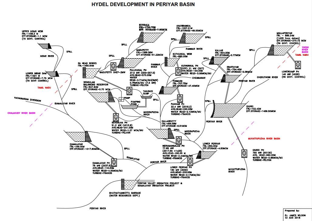
Let us start from the right side. The Mullaperiyar dam, constructed in 1895 by the British government, is the first dam in the Periyar river basin. Water from this reservoir is completely diverted to the adjacent Vaigai basin, first for power generation (Lower Camp powerhouse, 140 MW) and later for irrigation. The spill from this dam flows downstream into the gigantic Idukki reservoir, which is formed by three major dams – Idukki arch dam, Cheruthoni and Kulamavu gravity dam.
Idukki reservoir has an effective storage capacity of 1,460 MCM, and this water is diverted to the adjacent Muvattupuzha river basin to generate 780 MW at Moolamattom power station. So, water from these two reservoirs, which intercept 24 per cent of Periyar’s catchment, is diverted to other basins and only during spilling of the reservoir, do they discharge their water to the parent river, Periyar. The Kallar and Erattayar diversion dams in the Periyar augment Idukki reservoir.
Now, look at the central area of the flow diagram. Kundala dam, constructed in 1947 at 1758.70m (5770ft) from the mean sea level (MSL), in the Muthirapuzha sub-basin of the Periyar is at the highest elevation in this system. The water from this dam flows downstream into the Mattupetty dam. It has a small dam toe powerhouse of 2 MW.
But these two dams release water to the R.A. Headworks in Munnar and then the water is diverted to Pallivasal powerhouse where 37.5 MW is generated. Here, the tailrace water is collected in a pumping pond and pumped upwards towards the adjacent Sengulam dam to generate electricity at Sengulam powerhouse (51.2 MW). This tailwater along with the spill from the Mattupetty dam reaches the Kallarkutty dam.
Also read: Using new AI algorithm, IIT-Bombay to reduce damage caused by natural disasters in India
On the other arm of the Muthirapuzha sub-basin, there are Anayirankal and Ponmudi dams, which cater to the Panniyar powerhouse (32.4 MW). In between Anayirankal and Ponmudi, there is a small weir that diverts water to the non-government Kuthungal powerhouse (21 MW). The tailwater flows back into the Ponmudi dam. The tailwater from the Panniyar powerhouse and the spill from Ponmudi dam reach the Kallarkutty dam. So, the Kallarkutty dam is the recipient of flows from both arms of the Muthirapuzha sub-basin. The water from Kallarkutty dam is utilised for power generation at Neriamangalam powerhouse (77.65 MW).
The flow from Perinjankutty river, not yet tapped, along with any spill from Idukki as well as the tailwater of Neriamangalam powerhouse is received at the Pambla dam (Lower Periyar), which has an effective storage capacity of 4.5 MCM.
To utilise the huge quantity of water as well as keeping the peaking power station consideration in mind, the Lower Periyar powerhouse has an installed capacity of 180 MW. The tailwater from the Lower Periyar flows downstream into the Bhoothathankettu Barrage, which is at the lowest point of Periyar and intercepts a total catchment of 3,048 square kilometre (56 per cent of Periyar’s total catchment).
The barrage also receives untapped water from the Pooyamkutty sub-basin and the controlled release from the Idamalayar sub basin. This barrage was commissioned in 1966 and is spread over an area of 16.4 square kilometre. Periyar valley irrigation project, which has a gross irrigation area of 85,600 hectare under three crops, receives water from this barrage.
Also read: Kerala is pulling plastic from the oceans to build roads
Now, look at the left end of the flow diagram, which involves the Idamalayar sub-basin. The Tamil Nadu portion of the catchment area is on the northwest side above the Idamalayar river, known as the Nirar river (a tributary of Idamalayar).
Under the Parambikulam Aliyar Project agreement (1970) between Kerala and Tamil Nadu, the latter built the Upper Nirar weir and the Lower Nirar dam on this area. The water is diverted to the Sholayar reservoir in Tamil Nadu. But any spill from both these structures flows into the Nirar river downstream, which joins the Idamalayar river and finally the Idamalayar dam.
Idamalayar dam is the second largest reservoir in Kerala after Idukki, with a storage capacity of 1,018 MCM. But since it’s a low head dam, the power generation capacity is limited to just 75 MW. The tailwater after power generation reaches the Bhoothathankettu Barrage at Periyar.
In nutshell, these dams in the Periyar basin effectively store 2,930 MCM of water, which is 25 per cent of the Periyar’s annual flow. The Idukki and Idamalayar reservoirs alone store 21.3 per cent of the total annual flow of the river and play a major role in flood hazard management.
James Wilson is special officer, Inter State Water, Kerala
Thank you for the vivid information!
Dufus Dams
A dufus designed our dams to collapse when water level reaches top of dam
After spending millions why did they not design the dam not to collapse even if water level reached the top?
If that had been the case the spillover would not have the shock when gates are opened and the water will flow gracefully down unnoticed like the gently flowing waters of the Pamba
Selah
To summarize , y open the gates at all during heavy rains? What would have happened if the water spilled over the top?
If not properly fine tuned and planned, these reservoirs at a height of around 2400feet above mean sea level can also devastate the major revenue source of Kerala, Ernakulam District (Cochin) where Cochin International Airport Ltd, Cochin Port, Vallarpadom Transhipment Terminal, Cochin Shipyard, Kerala High Court, Southern Naval Command, Info Park..and around 40 लाख people are vulnerable to be wiped out. One reason is that Mullaperiyar dam is almost ramshackle and this masonry structure should have been decommissioned, maybe, 50 years back so that it does not act as water bomb on Idukki dam and the Ernakulam Dt. It is a clear and present danger, and a black swan especially during unusually heavy Monsoons. It is a complex dam. The rosy picture is a bit too naive.
As usual top class details from James in layman terms..Thank you