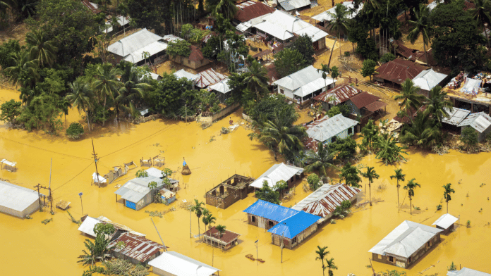
New Delhi: Tripura has been grappling with an unrelenting deluge over the past week, which has caused massive flooding across the state and in neighbouring Bangladesh, exposing the chinks in India’s flood management systems.
The heavy rains and flooded rivers have had a devastating impact on the state. According to state government data, 26 people have lost their lives so far and more than 17 lakh people — or about 40 percent of the state’s population — have been displaced. However, only 1.17 lakh of the affected people have been sheltered in 525 relief camps. About 1.25 lakh hectares of crops have also been submerged by the floods.
The government has blamed the heavy rains, exacerbated by climate change, for wreaking havoc in the state and causing immense loss of life and property.
However, some experts have blamed the crisis on delayed disaster management responses and inadequate flood forecasting systems in the country. They said central and state agencies missed early warnings, and the loss of life and crops could have been avoided had prompt action been taken.
The India Meteorological Department (IMD) categorised the 51.7 mm of rainfall in low-lying South Tripura districts as extremely heavy as early as 18 August. However, experts have argued that authorities did not take preventive action for the next three days.
‘Missed early warnings led to avoidable losses’
Himanshu Thakkar, coordinator of the South Asia Network on Dams, Rivers & People (SANDRP), said disaster management teams should have taken measures to reduce the damage on the morning of 19 August. “The extent of the damage could have been drastically reduced if the authorities had acted promptly, rather than waiting three days to respond.”
Tripura Chief Minister Manik Saha only made an official announcement about the flooding in South Tripura on X on 20 August, two days after the heavy rainfall began.
Experts believe the timely release of water from Tripura’s major Dumboor dam could also have given the state more time to prepare for the flooding.
The Dumboor dam, located over 120 km upstream of Bangladesh on the Gumti river in Gomati district, is a small hydroelectric project that generates power to meet the needs of both Tripura and Bangladesh.
For more than a week, from 16 to 23 August, the Gumti reservoir’s water level was at 92.6 metres, which is 86 percent of its storage capacity, Thakkar said, citing Central Water Commission (CWC) and IMD data.
After the heavy rainfall on 18 August, water should have been released from the Dumboor Dam based on the capacity of the downstream rivers, experts further said, adding that this would have created sufficient space in the dam’s catchment area to accommodate expected rains.
This could have provided the state and its residents more time to prepare for the floods in the downstream regions, according to Thakkar.
Government officials said dam operators evaluate the expected water inflow when heavy rains or floods are expected. “Based on this assessment, they decide whether to release water to ensure the reservoir doesn’t exceed its Full Reservoir Level (FRL),” a CWC official told ThePrint.
‘Hasty releases of dam water’
Experts however said authorities sometimes don’t act on time.
“In India, dam operations are often driven by fear. During the monsoon season, water is held back until the dam reaches its Full Reservoir Level (FRL) to prevent future droughts,” said C.G. Madhusoodhanan, CEO and co-founder of EQUINOCT, a Kerala-based start-up that provides solutions to address the impact of climate change.
“However, this practice poses a constant risk for flash floods in the downstream areas, even a small excess of rain can lead to sudden water releases without public warning. This may even lead to dam failures in extreme cases,” he added. “For example, the failure of the Machhu II Dam in Gujarat on 11 August 1979 is a classic example of how dams should not be operated during emergency situations.”
According to experts, India needs an impact-based flood forecasting system to prepare for such disasters. Citing flaws in India’s flood forecasting system, they stressed that accurate predictions require more than just rainfall data. Other crucial factors include infrastructure, soil moisture, groundwater levels and reservoir storage.
Madhusoodhanan pointed out that India currently has a flood monitoring system rather than a true flood prediction system. It mainly tracks water levels at specific stations within a river basin, providing information about the current situation but falls short in issuing timely warnings about potential flooding.
“IMD, in collaboration with various international organisations, runs customised high resolution numerical weather prediction models that provide seven-day advance rainfall predictions, both district-wise and river-basin-wise,” he said. “To improve our warning systems, we need to develop better impact-based prediction models by combining these data sets with observations of groundwater and reservoir levels.”
(Edited by Sugita Katyal)
Also read: Assam Rifles join rescue ops in Tripura as floods throw life into disarray in 6 of 8 districts


