


Dehradun: An expert panel set up by the Uttarakhand government has found that several pockets of Chamoli district’s Joshimath town — a gateway to the Badrinath shrine, the Hemkund Sahib gurdwara, the popular hill station of Auli, and the India-China border — are sinking due to both man-made and natural factors. As a result, the government will be putting together an action plan that may include a construction ban as well as relocation of local residents from “unsafe” areas, ThePrint has learnt.
The panel’s report points to ‘ground subsidence’ — a gradual settling or sudden sinking of the earth’s surface due to removal or displacement of subsurface materials — that has induced structural defects and damage observed in almost all wards of Joshimath. ThePrint has accessed the report.
The committee comprising scientists and geologists was formed on the recommendation of the Chamoli district magistrate in July following repeated complaints from the local populace about sinking areas and deep cracks appearing on the buildings.
“Although the government is yet to receive the report, going by the information provided by the committee members, a solid action plan will be put in place on engineering aspects as well as relocation of people from unsafe locations in Joshimath town,” state disaster management secretary Ranjit Kumar Sinha told ThePrint.
He further said that every house will be surveyed and a final report of relocation, if needed, will be prepared. “We have to resort to engineering methods for prevention of soil erosion and slope stabilisation of the town lying above the Alaknanda river.”
According to the 2011 census, the population of Joshimath municipal area was nearly 17,000, including around 4,000 families.
The expert panel has found that several pockets of Joshimath town are sinking due to speedy soil erosion, seismic causes and landslides.
“A detailed project report for engineering solution will be readied soon after the report comes to the government. No one will be allowed to live in dangerous areas of the Joshimath Municipal Council. If need be, the permission for construction of new houses and other buildings in highly [landslide and subsidence] prone areas of Joshimath will also be discontinued,” Sinha said.
Local residents, however, claim that the report failed to mention another factor that, according to them, is causing structural damage to buildings in Joshimath — an under-construction tunnel of the Tapovan Vishnugad Hydro Power Project, which passes from underneath the town.
The under construction project, which received environmental clearance from the Ministry of Environment, Forest and Climate Change in February 2005, was ravaged by flash floods triggered by a glacial burst in February 2021. More than 200 people working inside the tunnels of the Tapovan project and the Rishi Ganga hydel project had reportedly perished.
In June, the National Disaster Management Authority (NDMA) had, in a report investigating the aftermath of the 2021 Chamoli disaster, said that the government may need to pursue alternative sources of energy in the long run instead of relying on hydropower from Uttarakhand, given that the many hydropower plants set up in the Himalayan region are located in what it believes is an “environmentally fragile” area.
Also Read: Fears of lake burst in Uttarakhand village, authorities order inspection
What expert panel report said
Experts from the Council of Scientific & Industrial Research-Central Building Research Institute (CSIR-CBRI) Roorkee, IIT-Roorkee, the Geological Survey of India (GSI), the Uttarakhand State Disaster Management Authority and the Wadia Institute of Himalayan Geology are members of the panel formed by the Uttarakhand government.
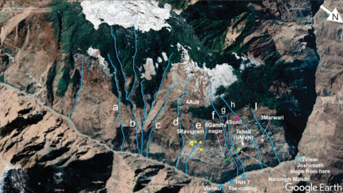
“Chamoli district of Uttarakhand that houses the township of Joshimath falls in zone V of the seismic zonation map of India and is particularly vulnerable to landslides. Joshimath is located over a thick cover of landslide material,” the panel’s report read, adding that the region had been witnessing gradual sinking for a long time.
It further said that evidence of ground subsidence had been observed in the downhill slope along the road at many spots, together with cracks and ensuing damages in a few houses.
“Sinking of roads and extensive cracks in houses are observed along Joshimath-Auli Road. Increased construction of residential houses, tourist resorts and small hotels are seen all along Joshimath Auli Road. The same was reported first by the Mishra Committee in 1976,” it added.
The township slope above the river is witnessing speedy erosion for various reasons, leading to subsidence of the landmass, the panel said.
“Above that riverbed on the slope housing Joshimath town, subsurface seepage erosions by natural drainage, occasional heavy precipitation, periodic seismic activities and the increased construction activities appear to be main causes of ground subsidence. Over the years, the burden of this fragile mountain slope appears to have increased beyond the sustaining capacity of the soil on which it rests.”
The report also mentioned that rainwater and household waste water flowing below the ground leads to high pore-pressure conditions in the soil, reducing its strength and resulting in instability of the slope.
Among other reasons, the panel report mentioned nine nullahs passing through the township into the Alaknanda. These nullahs, the report said, were expanding on their sides, causing soil erosion and damages to the houses constructed close to them.
Professor B.K. Maheshwari of IIT-Roorkee, a member of the expert panel, has issued a video statement informing the people that the team will further assess the findings after talking to local residents and visiting different places.
“Going by the local public, damages to their houses and subsidence of Joshimath town was aggravated mainly after two incidents — cloud burst on February 7 and heavy rain in October 2021. However there are substantial geological and geotechnical issues that we are examining,” he said in the video.
‘Missed’ main factor, claim local residents
A section of Joshimath residents claim that the government-constituted committee failed to pinpoint the main factors behind the shifting landscape. The National Thermal Power Corporation Limited’s (NTPC’s) ongoing construction of the Tapovan Vishnugad Hydro Power Project is one of the main causes of the damage to the buildings, according to them.
“It’s true that Joshimath town has had this issue for a long period. At least two hotels have submerged partially and crumbled in the past few years. Seismic activities and fragility of the Himalayas are the well-known reasons, but the huge under-construction tunnel of Vishnugad power project passing underneath Joshimath town is an important factor… However, the government has been ignoring it. It can lead to major decisions in coming days,” former Joshimath Municipal Council chairman Bharat Kunwar told ThePrint.
Local residents like Atul Sati are now venting their grievances on social media. “…this committee of scientific experts has not identified the tunnel of Tapovan Vishnugad hydroelectric project passing just below Joshimath among these factors [sic],” Sati, who identifies himself as an ‘activist’ on his Twitter account, tweeted Sunday.
Asked about the allegations surrounding the Vishnugad tunnel, Chamoli District Magistrate Himanshu Khurana said: “I cannot comment regarding the tunnel impact. Only those who studied it can comment on that. Earlier I got to know that some independent probe was undertaken but a proper scientific study was required.”
He further said: “We had received several complaints from the people and civil society about the cracks on the houses and irregular drainage system in the town. Hence, I requested the government for a detailed geological study of the town. I have also asked the irrigation department to prepare a drainage plan for dealing with the situation.”
(Edited by Tony Rai)
Also Read: ‘No public consultation’, razed forests: Manipur landslide raises questions on rail project