

")


New Delhi: Iran’s network of seven islands along its southern coastline has now become a crucial weapon in its ability to control maritime traffic, and influence the oil routes so critical in the ongoing conflict.
Positioned in and around the Strait of Hormuz—one of the world’s most vital energy chokepoints—these heavily fortified islands function as “unsinkable aircraft carriers”, enabling Tehran to monitor, regulate, and potentially disrupt global oil shipments.
While there is speculation that US ground troops may be preparing to take over Iran’s Kharg Island, a key fuel hub which handles 90 per cent of Tehran’s oil exports, some of the other islands may be equally crucial in this war.
But why does Iran describe them as its “unsinkable aircraft carriers”?
Tehran has outfitted its network of islands with radar systems, missile batteries, airstrips, fuel depots and naval launch points for submarines and fast-attack boats.
According to researchers, seven of these islands (Abu Musa, Greater Tunb, Lesser Tunb, Hengam, Qeshm, Larak and Hormuz) form what is called an ‘arch defence’—a curved chain of positions that allows Iran to monitor and potentially disrupt virtually all movement through the Strait.
The geography of the strait explains the islands’ importance. Though the waterway narrows to about 21 miles at its tightest point, ships must travel through two designated channels between the islands, each only about two miles wide. These lanes pass close to Iranian-held territory.
Also read: The real risk in a ground operation in Iran. It’s not about US capability
Strategic significance
Iran has increasingly used the islands to impose a form of gatekeeping over maritime traffic through the Strait of Hormuz. Reports say vessels may now be required to seek clearance through intermediaries linked to the Islamic Revolutionary Guard Corps, in some cases paying substantial sums for safe passage.
The islands’ importance extends beyond surveillance. They act as launch points for missiles and drones. Their fixed nature being immune to sinking means that neutralising them would require direct military action. This has placed the islands at the center of strategic planning.
Moreover, the arrival of the USS Tripoli Monday carrying elements of the 31st Marine Expeditionary Unit, now spotlights the possibility that amphibious operations could become the next phase of the conflict.
Tehran has warned that any attempt to seize its islands near the Strait of Hormuz including Abu Musa, Greater and Lesser Tunb, Hengam, Qeshm, Larak, and Hormuz would prompt a retaliation against the UAE far exceeding any attacks it has carried out since February 28.
Why Kharg is critical
Not all critical islands lie within the strait itself. Kharg is located hundreds of miles to the northwest, about 30 km off the coast of Iran. Despite recent US strikes targeting military installations there, oil operations have continued largely uninterrupted. The island’s deep waters allow large tankers to dock, link inland oil fields to global markets, and it has a network of pipelines and storage facilities.
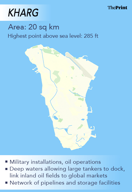
On 13-14 March, the US launched an aircraft and missile assault on Kharg aiming to eliminate its military installations but according to reports, spared the oil facilities.
An attempt to take it by force would be a complex and costly affair. Even with land based troops, holding the islands would involve thousands of troops, deft coordination between air, ground and naval forces and continuous evasion of Iranian missiles and drones.
Iran’s oil islands
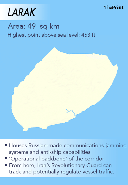
Among the most strategically positioned are Larak and Qeshm islands, which sit near the eastern entrance of the Strait of Hormuz.
Larak, only about 49 sq km, is a barren island which houses Russian-made communications-jamming systems and anti-ship capabilities, and analysts describe it as the “operational backbone” of the corridor. From here, Iran’s Revolutionary Guard can track and potentially regulate vessel traffic.
Qeshm island is around 1,500 sq km, the largest island in the Persian Gulf. It houses naval facilities, underground missile systems and energy infrastructure. Qeshm is also critical for Iran’s control of Hormuz and a key location for oil exports. It is located off the southern coast of Iran, opposite the cities of Bandar Abbas and Bandar Khamir.
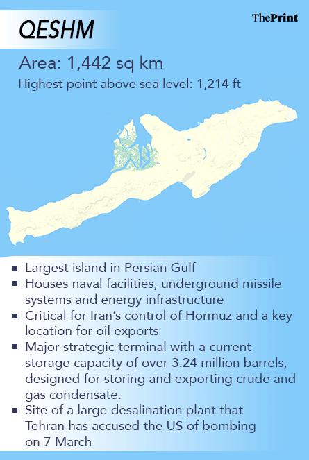
Qeshm island is approximately 180 km from the UAE’s Port Rashid. It acts as a major strategic terminal with a current storage capacity of over 3.24 million barrels, designed for storing and exporting crude and gas condensate. It is also the site of a large desalination plant that Tehran has accused the US of bombing on 7 March, calling it a “flagrant crime”.
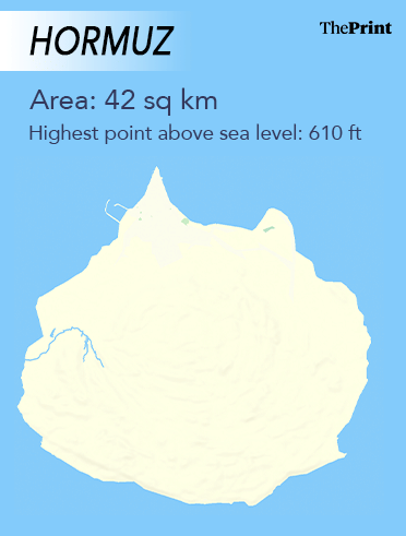
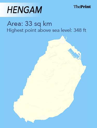
Smaller neighbouring islands, including Hormuz and Hengam, are similarly fortified, creating overlapping zones of surveillance and firepower. Hormuz island is located about 18 km north of Larak island and less than 10 km from mainland Iran.
Then there is Kish, which has an airstrip. Kish is a resort island covering 91.5 square km, located in Bandar Lengeh County, Hormozgan Province, along Iran’s southern coast in the Persian Gulf. According to an Economist report, after the Iran-Iraq war, Kish became a free zone with malls intended to rival Dubai. According to local reports, a strike was carried out on the airport of Kish island in Iran on 7 March.
Military presence
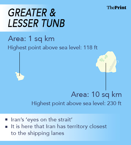
Iran has also built up a remarkable military presence and infrastructure on three smaller disputed islands—Abu Musa, Greater Tunb, and Lesser Tunb. According to the American advocacy think-tank, the Institute for the Study of War, US and Israeli strikes have been confirmed on the first two islands, both of which also have airfields.
These three sit directly between the inbound and outbound shipping lanes. Their proximity forces tankers and warships alike to pass within range of Iranian positions, making them especially sensitive flashpoints.
Abu Musa is closer to Dubai than Iran. It is a 12.8 sq km island in the eastern Persian Gulf. It was earlier a British dependent state along with the seven emirates that are now the UAE. In 1971, the Shah put troops on Abu Musa, Greater Tunb, and Lesser Tunb after the British left. Greater Tunb has a surface area of 10.3 sq km and is known for its red soil.
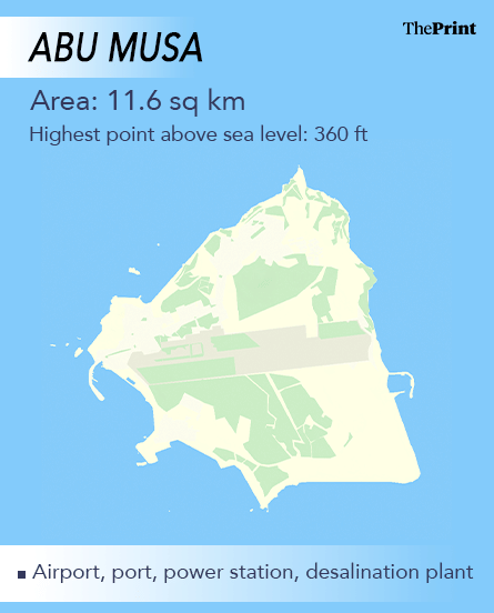
UAE still stakes a claim on the islands and labels Tehran’s actions at the UN as “illegal”. While Tehran asserts historical and geographical rights to the islands, the UAE in 2011 said it would take the matter to the ICJ.
Here’s the catch. The US has been supportive of its ally, the UAE, in its claim and hence cannot seize and return the islands to the new regime in favour of the UAE.
As of 2016 data, Abu Musa has a civilian population of 5,600, but Greater and Lesser Tunb have none. The two islands are called Iran’s ‘eyes on the strait’, and it is here that Iran has territory closest to the shipping lanes.
According to reports and satellite imagery by CopernicusEU, The Earth Observation component of the EU Space Programme, Abu Musa has been targeted multiple times but its runway remains intact—a signal that US plans to use its ground forces on the island.
According to a report by Israel-based Alma Research, the runway’s central Gulf location (110 km from the UAE) enables US forces to airlift troops and heavy equipment to counter Iranian threats. Initial strikes (1–16 March) targeted east side airfields, ports, power infrastructure and select bunkers, causing secondary explosions, while many bunkers remained intact.
(Edited by Viny Mishra)
Also read: This is how Strait of Hormuz shock is forcing a global trade reset
Debdutta: Why are you using a hodge-podge of units? In the same article, you have used miles, kilometers, square kilometers, and feet. All these units are interchangeable, so why not use the metric system of units consistently? Last I checked, India officially used the metric system of units…heck, we even invented the damn thing!
Other than that, a very informative article.