


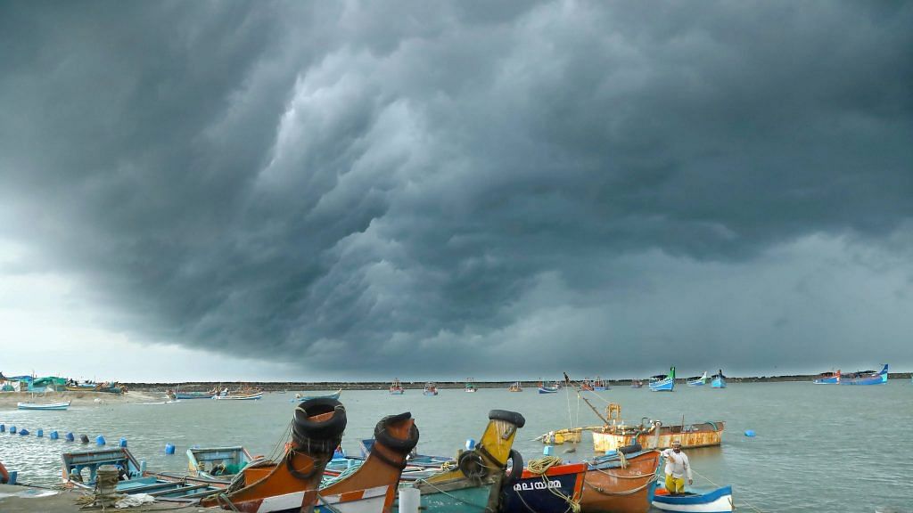
Bengaluru: The powerful Cyclone Tauktae (pronounced ‘tau-tay’ in Burmese) battered the coast of Gujarat Tuesday morning, unleashing a fury of rainfall and winds in the states along the west coast.
The cyclone is currently classified as an ‘Extremely Severe Cyclonic Storm’ and is the fifth-strongest cyclone ever in recorded history in the Arabian Sea.
It originated in the Arabian Sea and was first observed by the Indian Meteorological Department on 13 May moving eastward, and then subsequently north, while intensifying.
The storm moved along the coast of Karnataka on 15 May, beginning a rapid intensification from a ‘Severe Cyclonic Storm’ to a ‘Very Severe Cyclonic Storm’, and then to an ‘Extremely Severe Cyclonic Storm’.
The IMD categorises tropical storms, which rotate in an anti-clockwise direction, into Depression, Deep Depression, Cyclonic Storm, Severe Cyclonic Storm, Very Severe Cyclonic Storm, Extremely Severe Cyclonic Storm, and Super Cyclonic Storm. The last two have wind speeds of over 160 kmph and 210 kmph, respectively.
However, the presence of Tauktae in the Arabian Sea at this time of the year is concerning, and closely follows the very visible trend of an increasing number of severe, strong cyclones in the sea.
Also read: Navy rescues 177 from barge adrift off oil fields in Bombay High due to Cyclone Tauktae
Increasing numbers of cyclones in changing times
The Arabian Sea and the Bay of Bengal are both a part of the Indian Ocean, which extends on the west along the African coast and Madagascar upto the Arabian Peninsula and Gulf of Oman, down to the North Indian Ocean below India, along the Andaman Sea, and goes all the way to the Australian coast.
West Indian Ocean normally sees an extremely small number of cyclones and tropical storms. Between 1891 and 2000, 48 tropical cyclones impacted the west coast, of which 24 were severe cyclonic storms, while about 308 cyclones, including 103 severe cyclonic storms, impacted the east coast of the country from the Bay of Bengal.
Cyclones occur in the pre-monsoon months of May-June and the post-monsoon months of October-November. Among the cyclones that formed in the waters of the Bay of Bengal, over 58 per cent approached the coast during the October-November post-monsoon season, while 30 per cent did so during pre-monsoon season.
On the other side, only about 25 per cent of the cyclones that formed in the Arabian Sea, approached the coast during both pre- and post-monsoons.
However, in the past few decades, the average number of storms to occur over the Arabian Sea and the time of the year when they do have both demonstrated a changing trend.
In 2018, while the Bay of Bengal maintained its average of four cyclones a year, Arabian Sea gave rise to three instead of one. A year later, Arabian Sea saw five cyclones.
Overall, there was a 32 per cent rise in the number of cyclones between the years of 2014 and 2019.

The changing trends are consistent with rising temperatures in the Indian Ocean. A 2014 study found that while the temperature of the Indian Ocean rose overall by 0.7 degrees Celsius, the generally colder western Indian Ocean experienced an unexpected warming of 1.2 degrees Celsius in the summer.
Additionally, cyclones over the Arabian Sea are also increasing in intensity, driven by rising emissions and temperatures. Typically, an extremely severe cyclone occurs once every four to five years here. Between 1998 and 2013, only five extremely severe cyclones occurred in this part of the ocean.
However, 2014 saw Cyclone Nilofar and 2015 saw Chapal and Megh, all of which occurred in October and November.
The rising surface temperatures of the waters over the Arabian Sea is thought to be a leading factor in the increasing frequency and intensity of cyclones over it. Experts have also called for intensive monitoring of these waters for cyclones.
Also read: NDRF increases relief and rescue teams to 100 in the wake of impending Cyclone Tauktae
Bay of Bengal vs Arabian Sea
Tropical storms are those that form between the latitudes Tropic of Cancer and the Tropic of Capricorn, and rotate in the anti-clockwise direction.
The surface of oceanic waters heats up due to the sun and as warm air and moisture rise up from the surface of the warm waters, more air rushes to fill the space in. This air in turn rises with humidity, creating a cycle of warm, moist air rising up. This system grows in height and size, spreading out and causing a tropical cyclone.
Near India, cyclones form on either side of the country, but the ones in the Bay of Bengal are more frequent and more intense than in the Arabian Sea.
The Bay of Bengal is fed by a constant source of freshwater in the form of giant rivers like the Ganga and the Brahmaputra. The river water that empties into the Bay of Bengal warms up at the surface and rises up as moisture. This makes it difficult for the warm layers of water to mix properly with the cooler layers of water below, keeping the surface always warm and ready to feed any potential cyclone over it.
Furthermore, because of the shape of the land around the Bay of Bengal, the winds are slower and weaker over the ocean, ready to spin.
Conversely, the northern, central and western parts of the Arabian Sea have a much cooler temperature. The mountains in east Africa direct winds towards the Arabian Peninsula, dissipating heat much more efficiently throughout the Arabian Sea.
As a result, this region is not favourable to feed potential cyclones and about half the cyclones that move into this area typically lose energy and dissipate.
However, this year, the sea surface temperatures continue to remain abnormally high, in the 30s, feeding cyclonic conditions.
The Cyclone Tauktae was named in accordance with the list of northern Indian Ocean tropical cyclone names nominated by the 13 countries affected by the region: Bangladesh, India, Iran, Maldives, Myanmar, Oman, Pakistan, Qatar, Saudi Arabia, Sri Lanka, Thailand, U.A.E. and Yemen.
The name Tauktae, which means a gecko or lizard in Burmese, was nominated by Myanmar. The next cyclone will be called Yaas (Oman), followed by Gulab (Pakistan), Shaheen (Qatar), Jawad (Saudi Arabia), and Asani (Sri Lanka).
(Edited by Rachel John)
Also read: More floods, severe heatwaves: Govt predicts climate change impact on India this century