


New Delhi: Two separate analyses in 2020 and 2023 had warned of the vulnerability of Uttarakhand’s Dharali and Harsil areas, made worse by rampant construction along the Bhagirathi river and man-made obstructions to the river’s natural course.
In 2023, Navin Juyal, a former scientist at Ahmedabad’s Physical Research Laboratory (PRL), conducted a detailed independent analysis of Dharali and Harsil villages—the worst-impacted by the 2025 Uttarkashi flash flood in Uttarakhand.
Juyal highlighted that over the last decade, ‘hanging glaciers’—portions of glaciers that break off from the main ice caps primarily as a result of increased warming in the upper reaches of the Himalayas—had started giving birth to an increased number of smaller streams that were ultimately joining the Bhagirathi river and increasing its water flow.
While the National Disaster Management Authority (NDMA) is yet to confirm the cause of the flash flood in Uttarkashi, experts have hinted at a glacial flood being a possible cause for the disaster. Some experts have also suggested that a landslide-dammed lake at higher altitudes could have triggered the floods.
“Observations have shown that higher parts of the Himalayas are warming at a much higher rate compared to the lower regions. This would lead to glaciers melting at a faster rate, and thereby causing avalanches and floods in the lower regions,” Juyal had warned at the time.
Nearly five to six streams, fed by the Himalayan glaciers, go on to join the Bhagirathi. These streams don’t just carry water from the melted glaciers but also high amounts of sediments and debris when they flow down the mountains.
Cut to 2025, after these villages became victims of deadly flash floods, killing at least 16 according to the latest data released by the Uttarakhand government, Juyal told ThePrint authorities ignored warning signs.
“These streams have a history of intermittent flooding. Post the 2013 Uttarakhand floods, authorities started creating RCC (reinforced cement concrete) structures to control the flow of the river. That was the biggest mistake. We cannot try to control the flow of Himalayan rivers. The impact would be even more devastating,” he added.
Not the first warning
Juyal’s was not the only warning. In 2020, another study was conducted by scientists from the College of Forestry, VCSG Uttarakhand University of Horticulture and Forestry, Banaras Hindu University and HNB Garhwal University.
The study had highlighted that increased human interventions in the Bhagirathi valley had made the region vulnerable to natural disasters. “There should be a detailed multidisciplinary scientific study of the terrain likely to be submerged/affected by the power projects so that the collateral damage that occurred in the Bhagirathi valley is not replicated,” it quoted experts as having recommended.
Environmentalists and local activists said that despite such repeated and strong warnings from experts, authorities have allowed rampant construction along riverbanks.
What makes it worse for residents of these villages is the lack of early warning systems by the India Meteorological Department (IMD) in these high-altitude pockets, which could at least alert residents to evacuate in time.
“The monitoring network of the IMD in these areas is extremely poor. Most of these events are localised and require holistic monitoring. This is particularly absent in the Himalayan belt, even though it is one of the most climate change-prone regions,” said Bhim Singh Rawat, associate coordinator at the South Asia Network on Dams, Rivers and People (SANDRP), a think tank working on river management.
Satellite images
Satellite images of Uttarkashi before and after the flash floods show a shocking comparison of how the entire eastern part of Dharali village has been washed away.
Images released by the Indian Space Research Organisation’s (ISRO) National Remote Sensing Centre using its Cartosat-2S satellite show how the main Bhagirathi river, which used to channel out as Kheer Gad along Dharali, is now flowing as a single river, consuming the eastern part of the village.
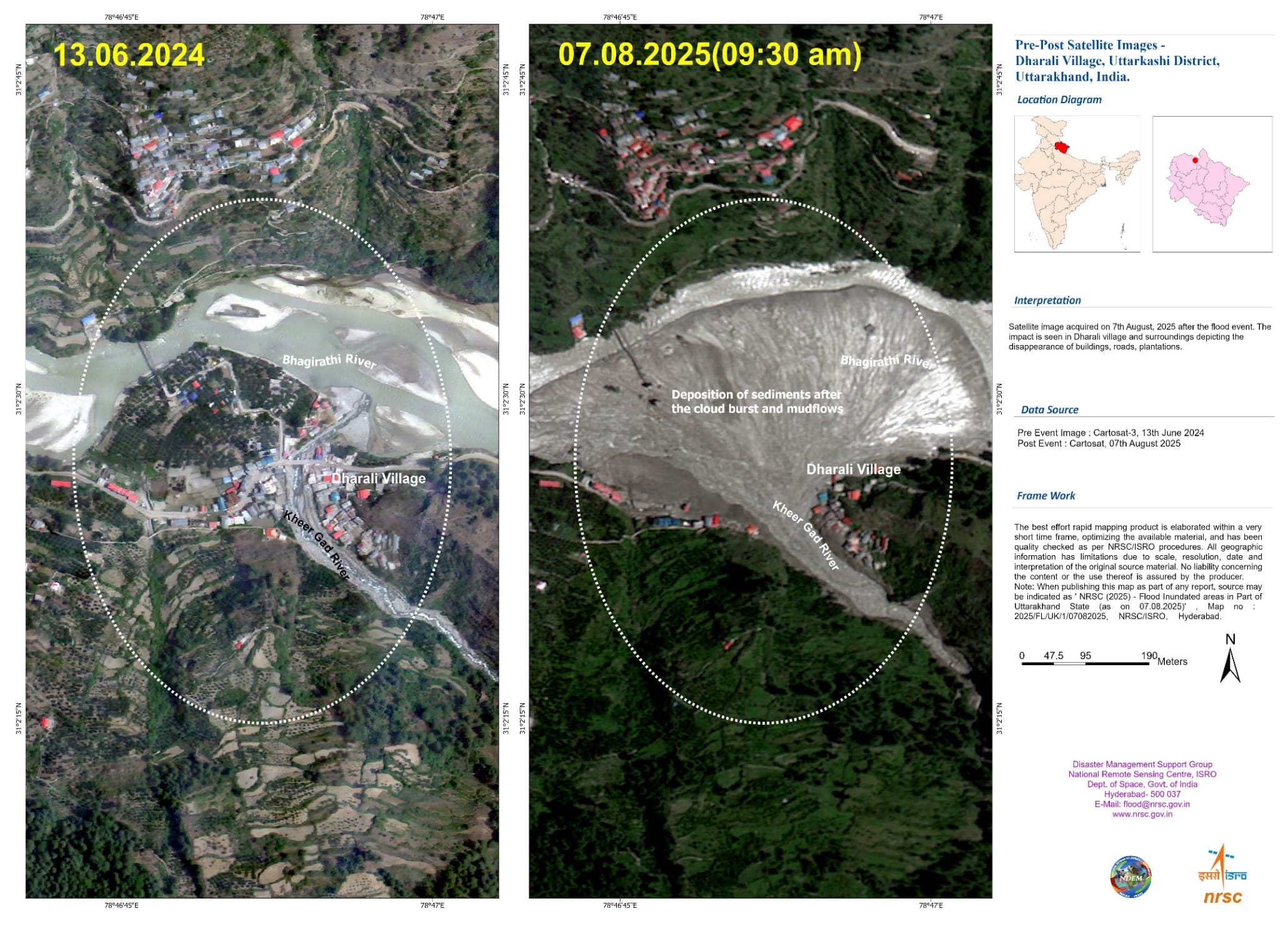
“A number of buildings appear to be submerged with mud/debris, in Dharali village,” the assessment read, adding that some buildings that were visible in images before the disaster have completely disappeared in recent satellite images.
(Edited by Amrtansh Arora)
Also Read: In flash floods-struck Uttarkashi, rescue ops continue under constant threat of ‘more landslides’