


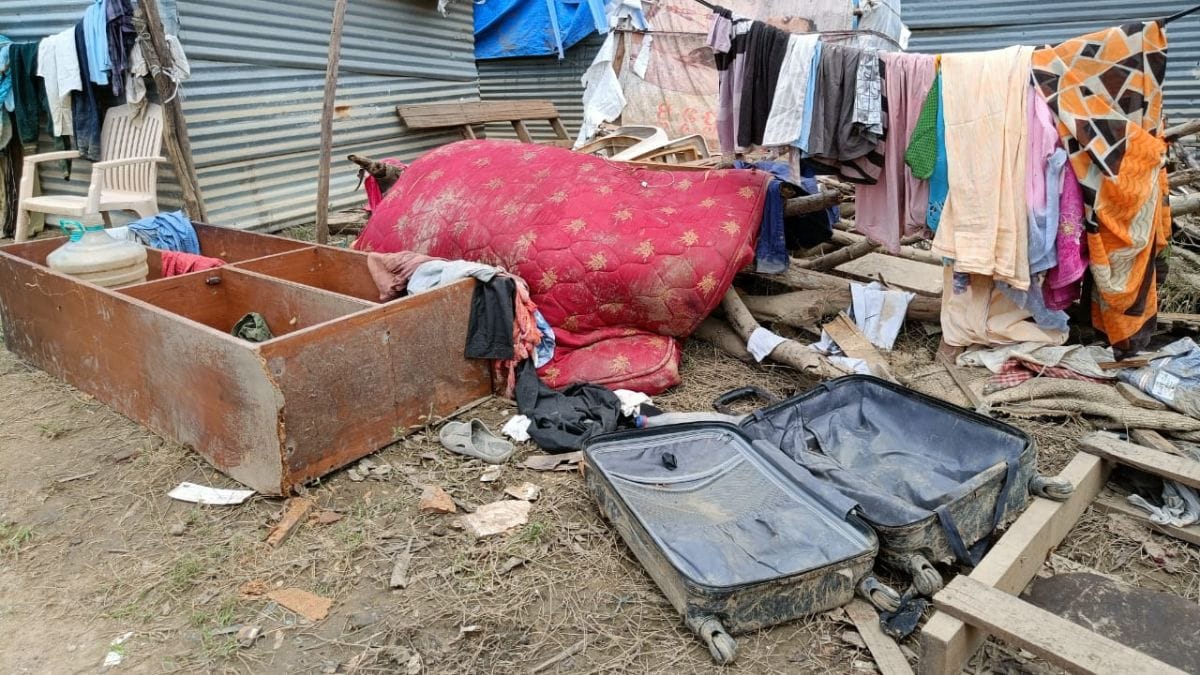
Bengaluru: Mattresses, shoes, piles of clothes, and schoolbooks are strewn about in damp heaps. At the small settlement in Saul Kere in Bengaluru’s Bellandur area, Shakuntala, a domestic worker, points to several white smelly heaps of rice on the ground. Nearly six kilograms of raw rice, ruined by the floods, which the families have just dumped on the ground. “Can you smell it?” she asked ThePrint. “It stinks.”
A week ago, water began to rush into Shakuntala’s shack. It rose steadily up — submerging her feet, then her calves, her thighs, ultimately her chest — she demonstrated, raising her palms all the way up. The community of daily wagers, around 20 families in all, occupy this piece of low-lying land surrounded by high-rise buildings. When the floods came, they rushed with their children and some belongings to take shelter in the parking lots amid expensive cars.
Within just 12 hours in the intervening night of 4 and 5 September, the city received 131.6 mm of rain, dumping high levels of precipitation on a city built over water bodies and afflicted with blocked drains.
Shakuntala’s children saw their schoolbooks float away, the family’s ration of rice and pulses lay soaked, and her clothes drenched. “The floods ate into all of the salary I earned on the first of the month,” she told ThePrint.
For most of last week, Bengaluru’s East Zone, including Yemalur, Rainbow Drive layout, Sunny Brooks Layout and Marathahalli, home to massive tech parks, saw water gushing down roads and flyovers past commuters and children heading to school. People used boats to cross streets and ladders to climb down from their apartments. The visuals were arresting, tech CEOs were being rescued in tractors.
When ThePrint visited these areas Sunday, under an overcast sky, the roads were dry, and traffic flowed smoothly. Across neighbourhoods were promises of a life made easy by technology. ‘India’s biggest AI conference’, read a large sign. ‘Cleanest co-living space’, read another.
“Now the issue is resolved. At least until it rains again,” Saiful Islam, a 23-year-old from Assam who sells tempered glass outside a tech park, told ThePrint. On his phone, Islam has videos and multiple photos of the floods from the morning of 5 September.
“My friend has a water tanker, so I rode along with him and captured images of that day. Water was just gushing towards people,” he grinned. By 9 am, the police had barricaded the road where Saiful sets up shop. “It was that lake over there,” he pointed in the direction of Bellandur Lake, “from where water was gushing.”
Speaking to ThePrint, water researcher and academic S. Vishwanath said, “We need to figure out how the intensity of rainfall has changed; it comes down in shorter and sharper spells which are continuous over many days.”
“Bengaluru will continue to urbanise more than it is right now, and during the rains, there will be more runoff than the rajakaluves [the Kannada word for the city’s stormwater drains] can manage. We have to put in place a new sewage infrastructure, solid waste management infrastructure…,” he added.
Also read: Bengaluru flooding will reveal how water can send your flashy, high-end car to scrapyard
Understanding Bengaluru’s drainage system
Half-a-kilometre away, outside another tech park EcoSpace, which was badly inundated, JCB machines were gnawing at the earth. Large concrete rings were being prepared to be embedded underground. “We have decided to put in a new drain connecting the outlet over there to the drain here,” explained a site supervisor to ThePrint.
The Bruhat Bengaluru Mahanagara Palike (BBMP), the city’s civic body, BESCOM, the city’s electricity supplier, were all weighing in.
The city’s water activists say that a combination of factors led to the flooding: terrain, infrastructure, management of Bengaluru’s lakes and roads not being well-designed.
On Bengaluru’s interweb, a webinar kicked off at 11 am Sunday on ‘Understanding Rajakaluves’ — the stormwater drains built during the British period. During the webinar, organised by Friends of Lakes, a citizen’s collective, an ex-Army officer Captain Santosh Kumar explained: “These rajakaluves are designed to carry the water to the next lake, it has to reach the next lake. They need to be desilted regularly and be kept to their standard optimal capacity. The capacity was not optimal in this area which led to flooding.”
In 2021, Captain Kumar had cleaned up encroachments in Anekal region of Bengaluru Urban District. He was concerned over the unabated illegal pumping of water from lake beds through borewells to cater to residents of Electronic City and Bellandur.
Vishwanath told ThePrint that it was not enough to only trust the old rajakaluves and lakes since they were never meant for stormwater management.
Further, he pointed out that it was the city’s land use plan that attracted large tech companies to set up shop. “It is not like they deliberately occupied low lying areas. They went there because there is no plan that the city puts up to say, here are the lake boundaries, here are the rajakaluves,” he said.
“There is no geo-tagging or geo-referencing of these sites, so there is no way for an ordinary citizen to find out if they are in violation of the law. In my view the culpability is not with them as much as it is with the government,” he added.
Vishwanath provided ThePrint with two viable options to avert disaster, if they can be scaled up. One is using weather apps like the Megha Sandesha, developed by the Karnataka State Natural Disaster Monitoring Centre in collaboration with Indian Institute of Science, which gives information on rainfall, flood, lighting, thunderstorm, and alerts. “That project quickly needs to be scaled up rather than wound down,” he said.
The second solution, he said, is building more networks like the K-100 Majestic to Bellandur drain network. “This project was taken up by architects and they have tried to clean up all the sewage flowing into the drain. During these rains, the K-100 did the job of a model stormwater drain,” he said. “It was a stone’s throw away from Bellandur.”
(Edited by Zinnia Ray Chaudhuri)
Also read: Heavy rain, poor drainage, worse infra — how Bengaluru was hit by a perfect storm and drowned