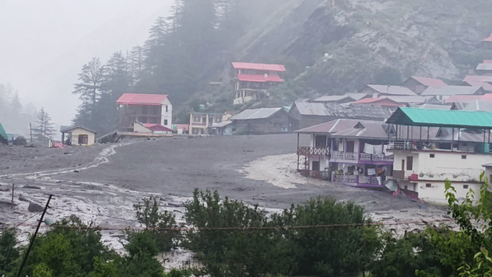
The deadly flash floods and landslides in Uttarkashi on 5 August, in which 16 people were killed, highlight the problems of illegal riverbank constructions and inadequate warning systems. Videos of submerged villages, ravaging floods sweeping up buildings and cars in their tide, and stranded people have become an almost annual occurrence now in the Himalayan region.
Dharali’s floods struck in the absence of any weather warning, and authorities are still confused about the actual cause. While the Uttarakhand State Disaster Management Authority called it a cloudburst, the India Meteorological Department could not confirm it with the available data. Uttarkashi district recorded 12.7 cm of rain in 8 hours on 5 August; it is still lower than districts such as Haridwar and Dehradun, which got 15-30 cms of rain on the same day.
In a state that sees frequent cloudbursts and floods during the monsoon, and has been explicitly marked as a ‘high vulnerability zone’ for landslides by the National Disaster Management Authority (NDMA), the damage from the Dharali floods is not merely nature’s fault. The blame also rests squarely on building norms, mass road construction and mining projects, and other anthropogenic activities that have exacerbated Uttarakhand’s fragility.
The floods should be another wake-up call for the IMD and the NDMA to buck up and ensure the safety of people and ecology in the Himalayas. And that is why Dharali is ThePrint’s Newsmaker of the Week.
What happened in Dharali?
Dharali is a small hamlet 2,680 metres above sea level, situated 18 km from Gangotri, and is a common stopover for tourists and pilgrims going to one of the Char Dhams of Uttarakhand. It is dotted with hotels, restaurants, and homes built precariously close to the banks of the Kheerganga River that runs through the village.
On Tuesday afternoon, a barrage of water descended upon the village and damaged houses, roads, and the one bridge connecting Dharali and Hershil, another area affected by the landslide. Satellite images from ISRO now show that deposits of mud and sediments from the floods cover all of the village. Alongside civilian settlements, an Army camp near Hershil too was impacted by the floods, although the number of people missing there hasn’t been reported.
The IMD had issued warnings of heavy to extremely heavy rainfall in all of Uttarakhand, including the Uttarkashi district, from 1 August onwards. But compared to other districts, Uttarkashi’s rainfall during this monsoon was still pretty low. From 1 to 5 August, Uttarkashi’s recorded rainfall was 6 per cent lower than the average rainfall it gets during this period. Over the monsoon season so far this year in the state, Uttarkashi has recorded 7 per cent lower rainfall than average.
If there was indeed a cloudburst—100 mm of rain falling in one hour in a small area—then the IMD is not aware of it. The closest Automatic Weather System (AWS) station that could record this cloudburst is 7 km from Dharali, and it did not catch a cloudburst.
But experts say that even without a cloudburst, the possibility of heavy rainfall causing this disaster is not unfounded. Dharali’s location and slope explain it.
“The ‘cloudburst’ may have happened much higher at 12,000 ft above sea level, and Dharali is at 8,000 ft. Even this slope of 4,000 ft makes a huge difference to the intensity of the water flow,” Mahesh Palawat, vice president of meteorology and climate change at SkyMet Weather, told ThePrint. “The canal is very narrow, and a lot of trees and mud could have been uprooted and swept along with the water.”
If extremely heavy rainfall can cause such damage without a rare event like a cloudburst, it should leave the system working toward India’s disaster preparedness thinking.
Also read: Gujarat to Bihar to Pune, India’s bridges are collapsing. Cutting corners on safety
Lessons from Kedarnath, Sikkim, Chamoli
A little over a decade ago, in 2013, Uttarakhand saw the worst natural disaster ever, where more than 5,000 people died in the Kedarnath cloudburst and ensuing floods. The resounding conclusion of experts and environmentalists back then was that unplanned construction of hotels and buildings, as well as hydroelectric, mining, and road projects, had made Kedarnath a disaster “waiting to happen.”
Since then, the Himalayas have seen at least 10 other such extreme weather events, including the Kedarnath floods in 2024, the Himachal Pradesh floods in 2023, the Sikkim Glacial Lake Outburst Flood (GLOF) in 2023, and the Chamoli floods in 2021. After each disaster, the authorities vowed to strengthen early warning systems, implement construction rules, and bring about climate-resilient infrastructure in the hills.
In Dharali, there were no AWS systems or Doppler Weather Radars of the IMD close enough to accurately predict the floods or the landslide and warn people to evacuate. Three days after the disaster, the authorities are still unsure about whether a cloudburst or a glacial lake outburst, or just heavy rainfall caused the event.
But geologists in Uttarakhand have a bigger question:
“How many times will the government issue warnings, and then an incident like this happens with loss of life and property, and then the government gives compensation again? Why are we allowed to build in unsafe places at all?” said Y.P. Sundriyal, a geologist based in Uttarakhand.
Evacuation measures are currently the need of the hour and are indeed being carried out swiftly by the NDRF, SDRF, and the Army. However, disaster management involves not just responding to a disaster but also preventing one. That is a steep curve India has to cover.
(Edited by Ratan Priya)


