New Delhi: Defence Minister Rajnath Singh Friday inaugurated the road route through Uttarakhand to reach Kailash Mansarovar, a pilgrimage site nestled in the Himalayas in Tibet, that almost goes up till Lipulekh Pass at the India-China border — 17,000 feet above sea level. Indians and Tibetans have been holding border trade at the Lipulekh Pass for quite some time now and the new road connects the pass to Dharchula, a town in Uttarakhand’s Pithoragarh distrtict.
Pilgrims from India can reach Kailash Mansarovar through three routes — via Sikkim, Uttarakhand and Kathmandu in Nepal — all of which are long and arduous.
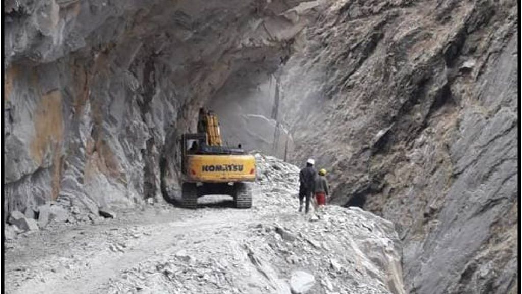
The route via Uttarakhand involves three stretches. The first stretch is a 107.6 km-long road from Pithoragarh to Tawaghat, the second is from Tawaghat to Ghatiabgarh on a 19.5-km single lane, and the third stretch is the 80 kms from Ghatiabgarh to Lipulekh Pass at the China border, which can only be traversed on foot. This stretch takes almost five days to cover and is a tough journey. Several accidents have occurred on this route.
The Border Roads Organisation is converting the second stretch into a double lane road and has built a new road on the third stretch to allow vehicles. It has completed 76 km of the 80-km stretch so far, cutting travel time to just two days by a vehicle.
The last 4 km of the road till Lipulekh Pass is expected to be completed by year-end.
This road is important for strategic and tactical reasons. The Sikkim and Nepal routes are much-longer and the road via Pithoragarh will ensure that most of the journey is within Indian territory. This is not the case with the other two routes that require pilgrims to enter Chinese territory.
Also read: New road for Kailash Mansarovar pilgrims is ready, will cut travel time by three days
Nepal considers Lipulekh its own territory
However, Nepal claims that the Lipulekh pass comes under its territory and lies in the Dharchula district in Sudurpashchim Pradesh. It is marked by the Kalapani river, one of the headwaters of the Kali River in the Himalayas at an altitude of 3,600–5,200 meters.
India has always considered Lipulekh as a tri-junction with the territory to the east of the pass as the Nepalese territory.
The Kali River forms the boundary between India and Nepal in this region. According to India, the headwaters of the river are not included in the boundary.
However, Lipulekh has always been on the Indian map and Nepal hasn’t protested until now. China also accepts that it belongs to India and that’s why it is allowing it as a route to Tibet.
India had closed Lipulekh from 1962 to 1991 due to the 1962 Sino-Indian war. The locals, Byansis of Kumaon, then used the Tinkar Pass for all their trade with Tibet.
Watch the latest episode CTC here: