


The territorial dispute between India and Pakistan over the Siachen glacier—the world’s highest military standoff for four decades, with over 2,000 lives lost—has much to do with a long history of cartographic errors, especially Hodgson’s Line.
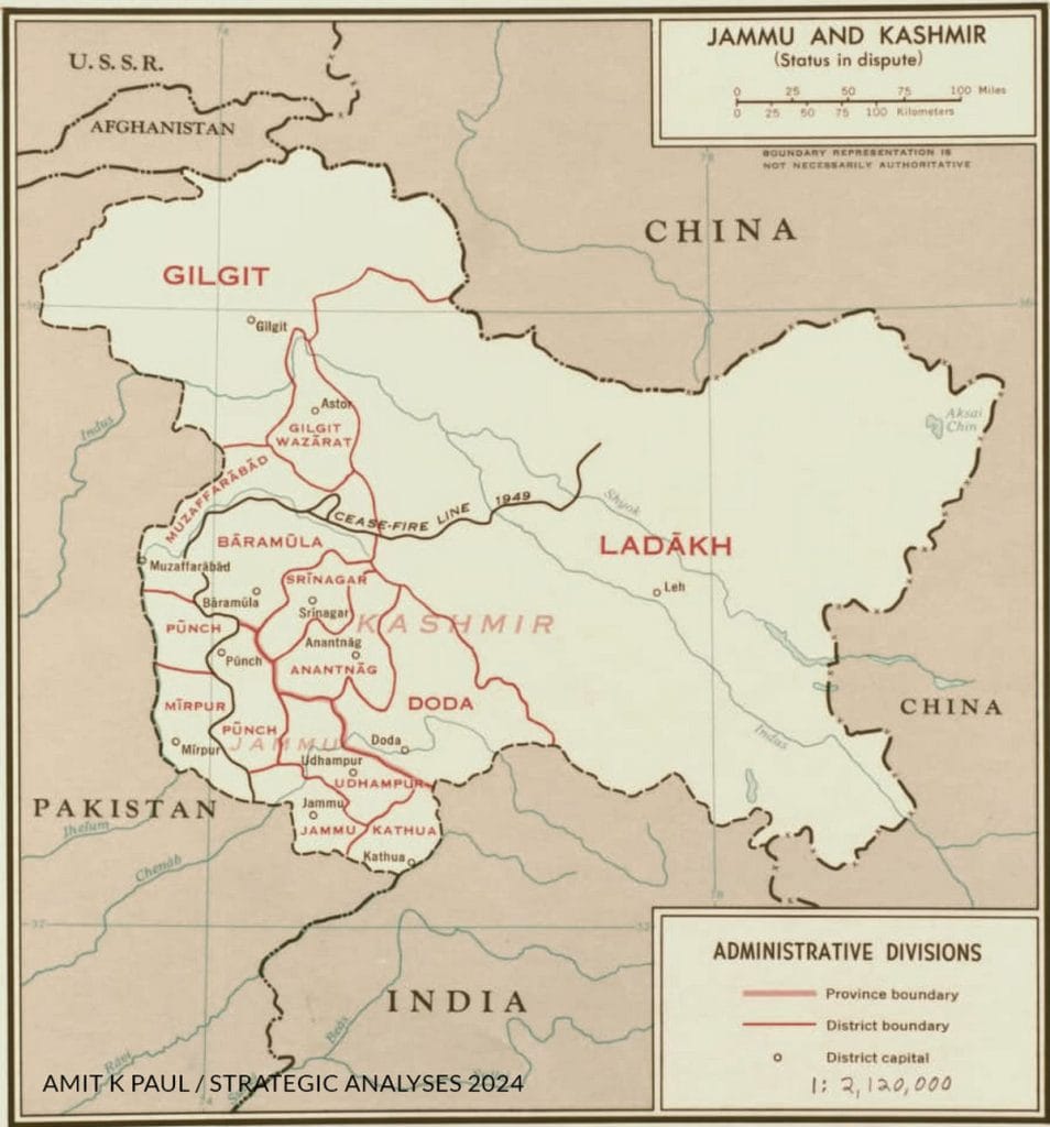
After the Karachi Ceasefire Agreement (CFA) of 27 July 1949, the ceasefire line (CFL) was demarcated till point NJ 9842 and delineated in maps prepared under the auspices of the United Nations Commission for India and Pakistan. Beyond this point the region was left demilitarised, pending its mutual demarcation and delineation per the agreement.
For decades, both sides accepted this. But on 21 August 1983, Pakistan in a protest note unilaterally extended the Line of Control from NJ 9842 to the Karakoram Pass (KKP) and formally staked claim to the region lying to its west. This set into motion a series of events which resulted in India moving onto the Strategic Saltoro Heights on the west of the Siachen glacier on 13 April 1984 to prevent Pakistan from altering the status quo in the region to its advantage.
But how did Pakistan’s claim line originate?
Also Read: Pakistan created a Gurdaspur myth for way too long. The truth was very different
A line in flux on maps
In the early fifties, when several books and papers were being written on Kashmir, it was incumbent on all authors to depict the CFL strictly in accordance with the CFA without deviating from the UN maps. Unfortunately, this did not happen, and distortions crept into the discourse. While some rightly left the CFL hanging in the air, pointing due north, others extended it to meet the State boundary at such point which they deemed appropriate.
However, not much attention was paid to the accuracy of the line, as the maps were only being used for representational purposes to depict the state of Jammu and Kashmir in the commentary, and the line itself was not a fact in issue. With multiple versions of the line floating around, it was not long before some prominent atlases like the 1956 Penguin Atlas of the World, too, fell into error.
While the Times Atlas of the World, Mid Century Edition published in 1958, does not show any CFL in the state of Jammu & Kashmir, its 1959 edition extends it to the KKP. In stark contrast, the 1967 Times Atlas of the World shows the CFL meeting the Karakoram Range near Sia Kangri. Thereafter, its 1977 Comprehensive Edition shows the CFL running west of the Siachen Glacier and joining with the China border near the Gasherbrum (Plate 31), at a point about 60 miles west of the terminal point shown in its 1980 edition, which too is not the KKP.
Even though the terminus of the line started oscillating between KKP and Sia Kangri in private publications, no official Pakistani map ever extended the CFL beyond NJ 9842 at any point of time, though they liberally distorted its orientation at the end.
Between 1953 and 1967, several maps showing Jammu and Kashmir were produced by various US government agencies for their own use, which invariably showed the status of Jammu and Kashmir as being ‘in dispute’. These included charts for military and navigation purposes, as well as maps produced by the CIA and the State Department. None of these extended the CFL to meet the state boundary.
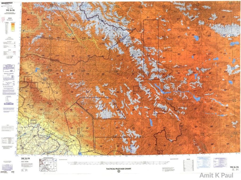
However, the 1967 Tactical Pilotage Chart TPC G7D, prepared by the US Army Map Service, depicting the Air Defence Information Zone (ADIZ) in this region, shows the CFL meeting the ADIZ line, which then extends straight from NJ 9842 to the KKP. Even though this was an internal document produced by the US government for its own use and had no connection with the territories of the state, it created a visual impression of there being a continuous line of separation between India and Pakistan in this region between NJ 9842 and the KKP.
There is enough cartographic evidence to show that till 1968, American policy was to depict the CFL agreed in the ceasefire agreement per the UN maps. The details of a tectonic shift in this policy became public only after the State Department declassified some documents around 2014, and Freddie Wilkinson broke the story in 2021.
The Hodgson directive
A study of these declassified documents reveals that during this time, efforts were being made by Indian diplomats to ensure that the US remove the ‘in dispute’ status of J&K from its maps and depict its boundaries correctly. Two Airgrams on this subject — A-415 dated 2 December 1966 by Chester Bowles, and A-1245 dated 27 June 1968 by William Weathersby — were sent by the US Embassy in New Delhi to the State Department, apprising them of Indian concerns and seeking guidance on how to represent India’s borders on US maps.
The task of resolving this issue fell on Robert D Hodgson, an assistant geographer with the Office of the Geographer at the US State Department.
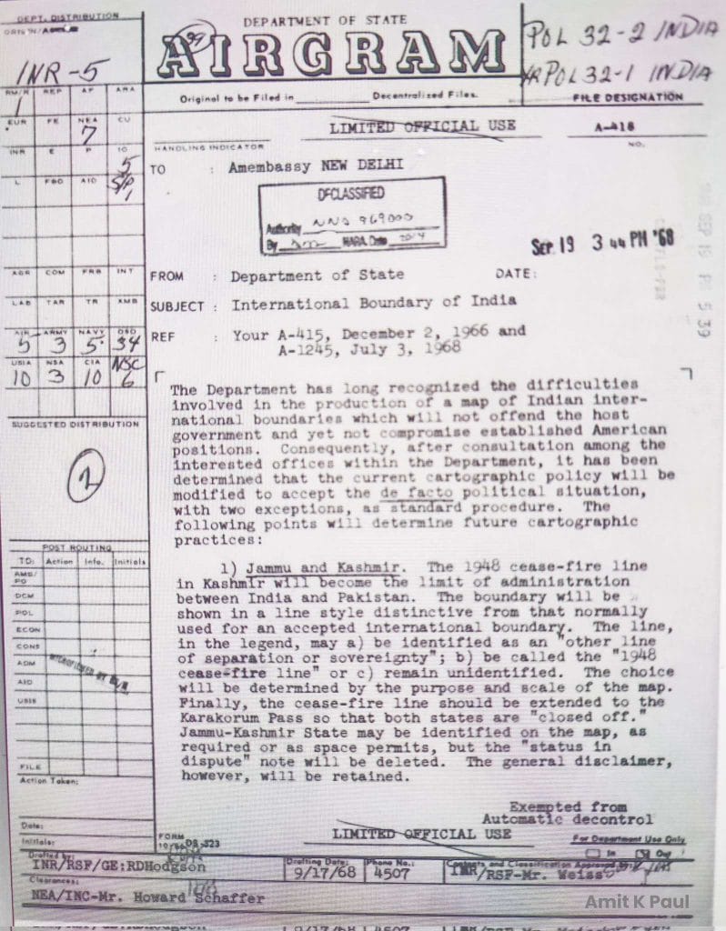
On 18 September 1968, Hodgson issued a fresh directive to the Chief of Mapping and Charting, Defense Intelligence Agency, as well as the CIA, and on 19 September responded to the queries of the US Embassy in India vide Airgram A-418. While dealing with the depiction of the boundary of Jammu and Kashmir, he decided that the CFL be extended till the China border on the Karakorams to ‘close off’ the boundaries of both India and Pakistan.
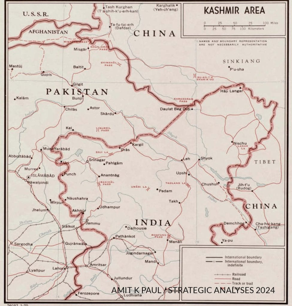
Since the Karakoram Pass was the agreed boundary point between India and China, with both being physically present on it, and also figured in Pakistan’s 1963 delimitation agreement with China, Hodgson probably reckoned it to be the most identifiable and convenient point on the Karakorams for this purpose.
He therefore directed that henceforth “the 1948 cease-fire line in Kashmir will become the limit of administration between India and Pakistan. The boundary will be shown in a line style distinctive from that normally used for an accepted international boundary. The line in the legend may a) be identified as an ‘other line of separation or sovereignty’ b) be called the 1948 cease fire line or c) remain unidentified. The choice will be determined by the purpose and the scale of the map. Finally the ceasefire line should be extended to the Karakorum Pass so that both the States are “closed off”. Jammu-Kashmir State may be identified on the map as required or as space permits, but the “status in dispute” note will be deleted. The general disclaimer, however will be retained.”
To assist the embassy, it was also proposed that a map would be made in Washington to incorporate these changes, and copies would then be made available to it for its use. It was also decided that a restricted order would be issued to federal mapping offices to change their representations of Indian international boundaries on official maps as and when they were revised, “so that less public attention is called to the change”, even though it would have meant that for a certain period official maps would be available with contradictory boundary alignments and sovereignty treatments.
Even though there is evidence of communication between some US government officials and the Pakistan air force in July 1968 on the depiction of the boundaries of J&K, there is nothing to show that any discussions took place on this extension. David Linthicum, from the Office of the Geographer and Global Issues at the US State Department, suspected that a “mapmaker’s fastidious desire to resolve ambiguity might have played a role in Hodgson closing off the boundaries rather than leave the line hanging in the air. ‘Some people have the completeness syndrome or completeness obsession where you have to fill in the gaps.’ If both countries were to be ‘closed-off’ as Hodgson wrote, the line would need to reach China to form a complete boundary- and the Karakoram Pass was the most identifiable point on the divide.”
After Hodgson’s directives of 18 September 1968, there was a visible change in the US policy of depicting the CFL in maps of Jammu and Kashmir. It was now being extended to the Karakoram Pass, and in some maps of the State Department as well as Defense (ONC G-7/1974), also being shown as an international boundary, contrary to Hodgson’s guidance.
As one of the largest and most influential map makers in the world, the US government influenced commercial map makers through what it published. Therefore, after 1968, even as various publications continued to show the correct position, this line too found its way into the mainstream. As a result, the entire region to the west of this line started to appear as being under Pakistan’s control, which encouraged explorers to seek permission from Pakistan to access it.
Since this new extension beyond NJ 9842 was neither an international border nor the actual ceasefire line agreed by India and Pakistan, Freddie Wilkinson rightly refers to it as Hodgson’s Line.
Also Read: The real truth about the ‘Standstill’ arrangement between Pakistan and Kashmir
Error erased, but not dispute
Linthicum confirms that the “Indian military and the Government repeatedly made written inquiries in the late 1970’s to Washington as to why the Defence mapping Agency was showing this erroneous line” but the Indian protests did not make much headway.
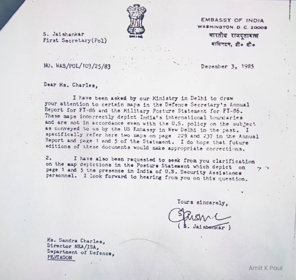
Thereafter, on 3 December 1985, Dr S Jaishankar, then First Secretary, Embassy of India, Washington DC, again raised the issue of depiction of J&K in American maps and wrote to the Pentagon, pointing out that “maps of South Asia in the Defense Secretary’s Annual Report and Military Posture Statement for FY 1986 fail to correctly depict India’s international boundaries and were not in accordance even with the US policy on the subject as conveyed by the US Embassy in New Delhi in the past.”
On 27 February 1986 George Demko, State Department geographer, acknowledged that the “DoD’s cartographic depiction of the India-Pakistan boundary which shows all of Kashmir in Pakistan in the Secretary of Defense’s Annual report to Congress for FY 86 is not in conformity with long established US policy.”
Differences between various US map-making agencies, as well as the DoD and the State Department, resulted in a comprehensive review of the matter within the US government and revealed inconsistencies in the depiction and categorisation of the India-Pakistan boundary across USG products.
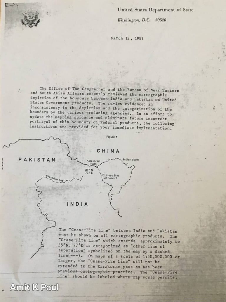
Thereafter on 12 March 1987 Demko issued fresh guidelines to eliminate future incorrect portrayal of the boundary on all federal products:
“In an effort to update the mapping guidance and eliminate future incorrect portrayal of this boundary on Federal products the following instructions are issued for immediate implementation. The cease fire line between India and Pakistan must be shown on all cartographic products. The cease fire line which extends approximately to 35 N, 77 E is categorized as ‘other line of separation’ symbolized on the map by a dashed line (–). On maps of a scale of 1:50,000,000 or larger the cease fire line will not be extended to the Karakorum Pass as has been the previous cartographic practice. The cease fire line should be labeled where map scale permits’.”
The guidance also specified that “if colour is used then the land tones should be shown using alternate colour bands indicative of the colour representation of both India and Pakistan.”
Thus, on 12 March 1987, the US government admitted that the depiction of the CFL in its products was incorrect, and the cartographic anomaly was rectified by issuing new guidance and maps terminating it at NJ 9842, without extending it to the Karakoram Pass. Hodgson’s Line, which had been introduced in 1968 to close off the boundary and subsequently followed by many, stood erased.
If the appearance of Hodgson’s line in the US and its replication by some map-makers created an erroneous impression and sowed the seeds of a possible claim within Pakistan, it is logical to assume that its disappearance and correction by those very agencies should have had the reverse effect.
Unfortunately, this did not happen.
Pakistan continues to cling to an imaginary line which has no legal, historical, factual, or cartographic basis, and continues to justify its existence using arguments conceived in hindsight and not borne out by any contemporaneous evidence.
The continued existence of Hodgson’s Line in Pakistan’s maps is more for cartographic convenience and cosmetology, because in the absence of this line its northeastern frontier would remain ‘open’ — nothing less than a cartographic nightmare for any map maker.
The writer is an independent researcher and author of the book ‘Meghdoot: The Beginning of the Coldest War’. Views are personal.
(Edited by Asavari Singh)