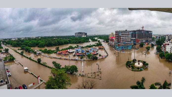
New Delhi: India’s monsoon season is winding down. This year, Gujarat was struck by record flooding while the eastern region saw little to no rainfall. In contrast, southern and central India received above-normal rainfall. All this is just as the India Meteorological Department (IMD) had forewarned.
The rainfall map of India from 1 June to 29 August is largely blue and green, which is a sign of either excess or normal rainfall. Over the past three months, the states of Rajasthan, Gujarat, Tamil Nadu, Karnataka, and Andhra Pradesh received more rain than usual, with some districts receiving more than double their normal amount.
The specks of red representing districts with deficit rainfall have been concentrated in eastern India, notably in northern Odisha, Bihar, Manipur, Nagaland, and Arunachal Pradesh.
“Of course, there are regional variations but overall, India’s rainfall looks good. It is 7 percent above average,” said Akshay Deoras, research scientist at the National Centre for Atmospheric Sciences and Dept. of Meteorology, University of Reading, UK, to The Print.
While the monsoon season is expected to last another month, current patterns indicate that the IMD was correct in anticipating excess rain in western parts of India and below normal in the eastern region. This is also the second year in a row that eastern and northeastern India has received below normal rainfall. In 2023, the region received 82 percent of its long-period average rainfall, which was the lowest among all regions in the country.
“A main feature of this monsoon is the reduced number of low-pressure systems, especially strong ones that are better known as ‘monsoon depressions’. Normally, around six of these form, but so far we have seen only two,” Deoras said. “This is one of the reasons why Bihar and parts of east India have seen deficit rainfall.”
Also read: Wettest 24 hours in June since 1936 — what caused Delhi’s intense but short-lived downpour
Regional variations in rainfall
While Jharkhand and Odisha still managed to get normal rainfall overall, certain districts in these states have seen a deficit of 30-50 percent in their normal rainfall over the past three months.
Aside from eastern India, northern states like Punjab, Himachal Pradesh, and Jammu and Kashmir have also witnessed rain deficits. However, southern and peninsular states like Andhra Pradesh, Tamil Nadu, Maharashtra, and even Kerala have seen either excess to normal rainfall. Despite the devastating landslides caused by heavy rains in Kerala last month, overall rainfall in the state has been normal; Wayanad, the epicentre of the landslides, has actually recorded inadequate rainfall.
Deoras explained how localised events like the Wayanad landslides or the Delhi rains do not have a huge impact on the monsoon of a region.
“Yes, there have been extreme rainfall events like in Wayanad and earlier in Delhi too, but these were heavily localised events that do not affect the overall monsoon statistics of the area,” he said, adding that they’re also a common feature of monsoon season, subject to local circumstances.
Another common feature of monsoons in India missing this season are ‘monsoon breaks’. These are declared when there are at least three consecutive days of very poor rainfall over the core monsoon region of central India. According to IMD, these breaks usually occur when the monsoon trough—an elongated low-pressure area stretching from East to West India—shifts from its regular location, resulting in extreme rainfall variability over the country.
“While this season there have been, surprisingly, no monsoon breaks, last year in August there were two large breaks. It was overall bad for the country’s rain,” said Deoras. The lack of monsoon breaks also indicates a relatively strong monsoon wind pattern, as the chance of breaks occurring goes up when the overall monsoon pattern is weak.
However, despite a strong monsoon circulation, certain parts like western India received a lot more rainfall, marking them as being in excess or large excess of their normal rain for the season. Some districts like Jodhpur, Bikaner, and Jaisalmer have seen almost double their normal amount of rainfall this season.
The reason for this, according to Deoras, lies in two factors. First, a strong monsoon depression—one of the two that has occurred this season—moved westwards during the beginning of the month and brought a lot of rain to these places. Second, the long-period average rainfall of these regions, i.e, the 30-50-year average rain against which seasonal rainfall is calculated, is quite low to begin with.
Deoras further explained that the normal rainfall received in these areas is, in general, quite low. “So, when a strong depression dumps all that rain in those regions, it automatically becomes excess. However, the same amount of rain in central or eastern India would not be as much, because the normal rainfall in these areas isn’t as low as in Rajasthan or Gujarat.”
(Edited by Tarannum Khan)
Also read: Wettest 24 hours in June since 1936 — what caused Delhi’s intense but short-lived downpour


