New Delhi: Monsoon arrived in Delhi with a bang Friday as heavy showers lashed most parts of the city, breaking a historical 88-year record for the highest 24-hour rainfall in June, the India Meteorological Department (IMD) said.
Rain will continue over most parts of northwest India for at least ten days.
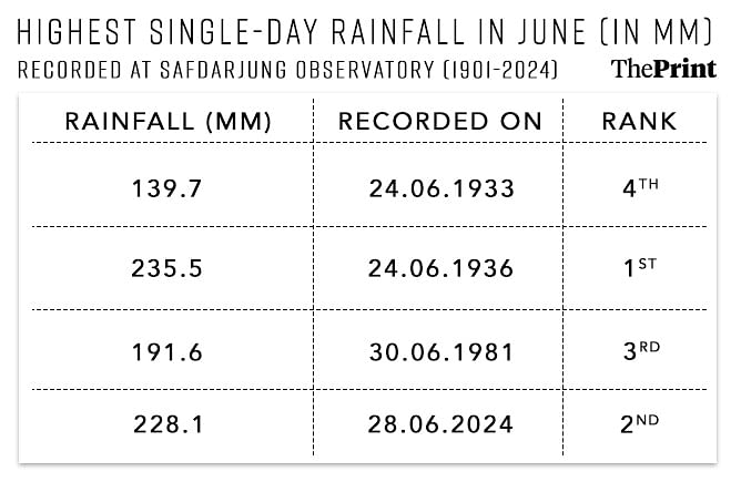
According to the IMD data, Delhi’s representative station Safdarjung received 228.1 mm of rainfall — the highest single-day rainfall record in June since 1936. This marked the arrival of the southwest monsoon in Delhi, Haryana, west Rajasthan, Madhya Pradesh, Chhattisgarh, West Bengal, Jharkhand, Bihar and some parts of east Uttar Pradesh.
“Conditions are likely to become favourable for further advance of southwest monsoon into some more parts of West Rajasthan, remaining parts of Haryana, entire Chandigarh and remaining parts of Punjab, Uttarakhand, Himachal Pradesh, and Jammu during next two to three days,” the IMD said.
Record-breaking rain
The rainfall recorded at Delhi’s Safdarjung weather station Friday narrowly missed the spot for the highest ever. Before this, on June 24, 1936, 235.5 mm of rainfall was recorded.

According to the IMD data, the Lodhi Road observatory recorded 219 mm of rain, followed by Delhi University, which recorded 139 mm of rainfall and Pitampura, which received 138 mm of rain on Friday. Most pockets in central Delhi also recorded above 50 mm of rain.
With a single day’s rain, June this year also covered the rainfall deficit in Delhi and became the third wettest June in the last 124 years — between June 1 and 28. In June of 1936, 415.8 mm of rainfall was recorded, followed by 1933, when 399 mm of rain was recorded.
Friday’s rain came as a relief to the city, which was in the grips of an intense heatwave for the last two months. Since May this year, the daytime temperatures soared to nearly 50 degrees Celsius. The high nighttime temperatures also increased the region’s heat stress.
Short spells of rain recorded earlier this month did not do much to bring relief to residents.
What caused intense rain
The IMD data showed that heavy showers were recorded in most pockets of the city Friday. Most rainfall was also received between 3 am and 5.30 am, after which the intensity reduced.
Experts said that the heavy rainfall in Delhi resulted from two cyclonic circulations, which constitute a swirling motion of wind caused by a low-pressure area, active around the city.
Mahesh Palawat, vice-president (meteorology and climate change) at Skymet Weather, a private weather forecasting service, said the two cyclonic circulations — one over Uttar Pradesh and the other over northwest Rajasthan — created a trough, which was passing through Delhi. This, he said, caused the heavy downpour over the capital.
“We also saw that the clouds over Delhi were getting regenerated, causing intense rains that lasted only for a few hours. It rained early in the morning for a few hours, and then only a few places received light rain,” Palawat said.
In certain cases, clouds over a region tend to “regenerate” because of high humidity levels and temperatures. The combination becomes conducive for consistently forming rain-bearing clouds, which causes heavy rain.
Forecast
IMD scientist Soma Sen said that heavy to very heavy rainfall will continue over the entire north of India for the next two to three days.
“For Delhi also, we have issued a heavy rain warning for tomorrow (Saturday) and the day after tomorrow (Sunday),” Sen said.
Palawat said conditions are conducive to similarly high-intensity showers across Delhi on Sundays.
“Two cyclonic circulations are likely to merge over Delhi again and cause heavy rain,” he said.
(Edited by Madhurita Goswami)


