

")


New Delhi: In 2019, Bhagwan Singh, a 69-year-old resident of northwest Delhi, bought two acres of agricultural land in Kanjhawala village. But five years later, Singh hasn’t managed to get the property registered in his name or complete the mutation process of changing ownership details in the Delhi government’s revenue department records.
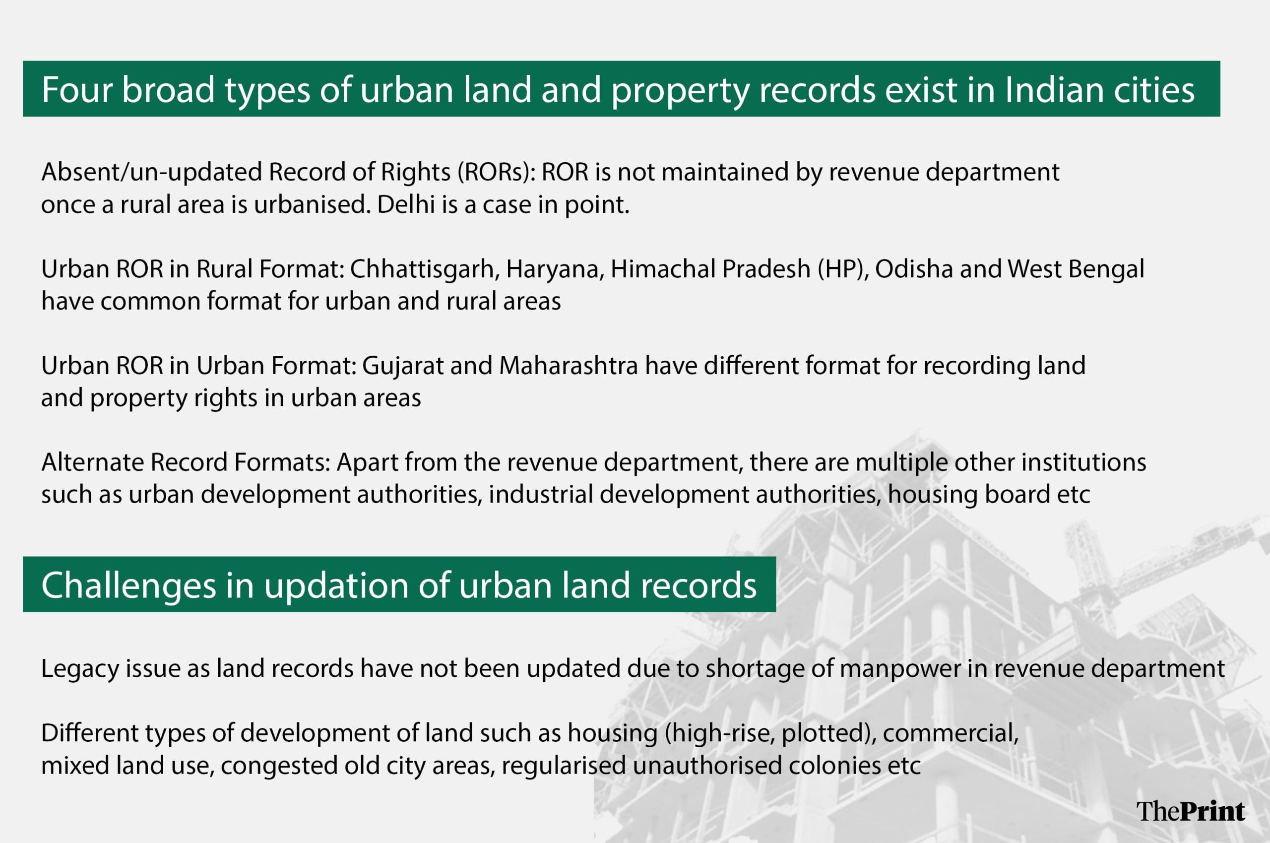
The reason? Kanjhawala was categorised as an urban area in 2018 under a land pooling policy and the Delhi government’s revenue department no longer maintains its land records.
“Once a village is urbanised, land-related details are maintained by development authorities or the municipal corporation. The Delhi government doesn’t maintain any land records for urban areas,” a senior official with the Delhi government’s revenue department told ThePrint.
Singh is among many frustrated landowners struggling with property registration in Kanjhawala, one of 105 villages identified for development under Delhi’s land pooling policy where property mutation has been on hold since 2018 when they were declared urban areas.
“It is creating a lot of problems for the people, as all land deals in the village have not been registered with the government for the past five or six years. Once the land pooling policy is implemented, it will become difficult for us to prove our ownership,” said Singh.
Delhi’s struggles highlight a broader challenge of urban land record management seen across the country—the lack of robust land and property record systems to maintain accurate and updated records.
Only a few states such as Karnataka, Maharashtra and Gujarat have a system of urban land record management in place, but most cities are still grappling with a host of challenges from outdated land records to the involvement of multiple agencies.
Although the property registration system has been streamlined through the computerisation of registration offices, property mutation, which updates corresponding changes in revenue records, is not regularly updated in most cities, according to senior officials with the Department of Land Resources under the Union Rural Development Ministry.
Unlike rural areas where land transactions are not frequent and land records are available, urban areas face multiple challenges in maintaining land records due to frequent property transactions, fraudulent registrations and the rapidly changing nature of land development.
Recognising the need for reform, Union Finance Minister Nirmala Sitharaman announced a nationwide push to digitise urban land and property records in the 2024-25 Budget to standardise record-keeping, simplify processes and bring transparency in land transactions.
In October, the Narendra Modi government launched a pilot project, the National Geospatial Knowledge-based Land Survey of Urban Habitations (NAKSHA), to create updated digitised land records in 150 cities across the country in the next year. The Centre has allocated Rs 5,000 crore for the first phase.
This comes after the successful implementation of two crucial Central government schemes — the Digital India Land Records Modernization Programme (DILRMP) and the Survey of Villages and Mapping with Improvised Technology in Village Areas (SVAMITVA) scheme — to modernise land records in rural areas for agricultural land parcels and residential areas.
“While a lot of work has happened in rural areas to streamline and modernise the land record system, a majority of cities don’t have a proper system in place to maintain land records,” said a senior ministry official.
“The main objective of NAKSHA is to link each land parcel with details about the owner of the land and the type of development on it. For instance, if there is a multi-storeyed apartment on a land parcel, the digitised map will have details about coordinates of the land parcel along with details of its owners.”
With nearly 40 percent of India’s population expected to be living in urban areas by 2030, according to the 2023-24 Economic Survey, and large-scale investment in urban areas, experts say streamlining land and property record systems is essential for the planned development of cities.
In a policy brief titled ‘Urban land and property record systems in India: The case and agenda for reform’ last year, the Indian Institute for Human Settlements (IIHS), an educational and research institution, highlighted the need for cities to maintain urban records.
“The process of such investment-making is generally one ridden with anxiety, primarily on account of uncertainties around titles to land,” IIHS said in the brief authored by Deepika Jha, Manish Dubey and Amlanjyoti Goswami.
“Improved urban land and property record systems can ensure legal recognition and protection of citizens’ interests, address anxieties associated with the transaction process, and reduce land-related disputes in the long run,” it added.
A daunting task
However, unlike rural areas, digitising land records in urban areas will be a daunting task because of a tangled web of problems.
The biggest challenges are the absence of cadastral maps, poorly maintained land records, the complex nature of development—particularly in villages that have been urbanised—and the mushrooming of illegal colonies and slums on government land in most cities.
Land administration and urban planning experts say other challenges include delays in updating records due to a shortage of manpower and a lack of integration with other land-related services, including property sale registration.
“In most cities, cadastral maps are either missing or haven’t been updated. The property record and the ownership of land are not synchronised,” a senior official with the Department of Land Resources (DoLR) under the Union Ministry of Rural Development, which is spearheading the initiative, told ThePrint.
“This results in problems in the mutation of property and land dispute redressal.”
The IIHS policy brief highlighted the reasons for the gaps in urban land record systems.
According to the brief, land records in some states have not been updated after rural areas were declared as urban.
“In some states, the Record of Rights (RoR) is absent or not updated after areas are declared urbanised since revenue departments, who act as custodians for rural land records, view the urban as a municipal or development authority concern,” says the policy brief.
Deepika Jha, one of the brief’s authors, said one of the biggest challenges in many cities is dealing with legacy issues.
“Land records have not been updated on a regular basis due to a shortage of staff and the revenue department, which maintains these records, is not equipped to maintain the records based on what is actually needed to run the city. It doesn’t have details such as type of development (highrise, commercial, etc) on the land, how many flats are in the building, etc,” said Jha.
In urban areas, land changes its form very rapidly, said Jha. “Within a span of three to four decades, we can notice a lot of changes in the type of development on it. For instance, a house can come up on a vacant land and then it can be demolished to pave the way for a multi-storeyed apartment or its land use can change to commercial as the city grows,” said Jha.
NAKSHA to create uniform digitised data
The NAKSHA scheme seeks to address these issues and streamline urban land record systems. The scheme will be rolled out across 27 states and Union Territories.
As part of the initiative, authorities will conduct a survey of an entire city using drones to create cadastral maps marking the boundary of each land parcel.
Subsequently, a team of officials from the state’s rural and urban departments will carry out a field survey to authenticate the accuracy of aerial images and check ownership records to demarcate the boundaries of each land parcel and record property ownership details, the official said.
A DoLR official, who did not want to be identified, said that one of the key challenges in urban areas is the multiplicity of ownership of land.
Unlike rural areas where one residential property is constructed on one parcel of land, cities have group housing societies and apartments, multiple owners of a plot even in residential colonies, mixed land use developments and unauthorised colonies.
To address this issue, the Centre plans to create GIS-based cadastral maps that will include the coordinates of each land parcel and the type of development on it.
“The land records will reflect the coordinates of the land along with ownership details. If there is a group housing society, it will mention the ownership details of the land and the nature of construction on it. If there is unauthorised construction on government land, then land records will not reflect the type of development in them,” said the official.
The states will also have to prepare GIS-ready land parcel maps along with land property details.
“The final maps and land records will be prepared after resolving all disputes and claims. The exercise will start soon and we aim to complete it within a year,” the official said.
Experts say the process of digitisation should be carefully phased.
B.K. Aggarwal, former chief secretary of Himachal Pradesh and author of Land Registration: Global Practices and Lessors for India, said that digitising land records in urban areas should be implemented in phases and the survey approach should be carefully planned.
“For digitising land records in urban areas, the concept of ‘fit for purpose land administration’ should be adopted. It is an international concept for developing countries which recommends that land records should be created as per the requirement,” Aggarwal told ThePrint.
According to him, digitising records is a time-consuming exercise due to the sheer volume of land records.
“There is no point in creating land records, which can’t be used for years. In my opinion, the exercise can be done in parts. Carrying out a survey is easy, but ground-truthing and resolving disputes is a time-consuming task,” Aggarwal said.
“If it takes years to create the land records, then the purpose will be defeated. I think there is a need to carefully plan surveys in cities.”
Also Read: Rajasthan’s elderly are victims of ‘digital murder’. eKYC gaps leave lakhs without pension
Need for digitisation in urban land records
Digitisation of urban land records may be fraught with challenges but experts say it is essential for urban development.
The NITI Aayog in its report titled ‘Reforms in Urban Planning Capacity in India’ said that updated maps and land records are essential for better planning and development of cities.
NITI Aayog said that in urban areas, land faces competing demands due to market forces, social needs and environmental concerns. If a city’s land use plan diverges from the status of land records, it may not be effectively implemented on the ground.
“Such divergences become a potential cause of unnecessary and time-consuming disputes and litigations. Accurate cadastral maps and clarity about property rights are very important for successful planning,” the report said.
“Such maps do not exist with the city functionaries or in the public domain for most Indian cities. This is a big impediment in the planning process.”
With the increase in population, demand for housing is rising in cities. But poorly maintained land records often delay the process of buying private land, developers said.
“Due to lack of clarity about land titles in cities, buying private land becomes a time-consuming process,” said Harshvardhan Bansal, president of the Delhi chapter of the National Real Estate Development Council (NAREDCO).
“Developers have to hire agencies to get land ownership verified to ensure that there are no pending court cases or bank loans against land parcels. This results in delays in important infrastructure projects.”
Bansal further said that there is an urgent need to put in place a land and property record system as redevelopment projects are being planned in cities.
“In Delhi, the lieutenant governor has formed a committee to explore the possibility of undertaking new redevelopment projects. If land ownership records are made available online along with important information such as pending court cases etc, then it will speed up planned development or redevelopment of cities,” said Bansal.
Land rights experts emphasise the need for a system to regularly update land record titles. The absence of updated land records creates problems, particularly when there are court cases or the government plans to acquire land or property for development projects.
Improved urban land and property record systems can ensure legal recognition and protection of citizens’ interests, address anxieties associated with the transaction process, and reduce land-related disputes in the long run.
States experiment with different models for land reforms
Despite the maze of problems in most cities, some states such as Gujarat, Maharashtra and Karnataka have their systems in place while others are experimenting with new digitisation models.
For example, the Madhya Pradesh government started a pilot project last year using drones to prepare geo-referenced land maps along with property details of three different types of residential settlements in urban areas—an old and upscale neighbourhood, a resettlement area, and an urbanised village.
It was an exercise started by the state government much before the Centre conceived the NAKSHA plan.
“We have used drones to prepare the maps of these residential areas and earmark boundaries of each property. This was followed by a door-to-door survey to verify the property ownership details. The exercise is nearing completion,” said a senior official with the Madhya Pradesh government’s revenue department.
Similarly, the Delhi Development Authority (DDA), the land-owning agency in Delhi, has started a survey to streamline land and property records in the national capital.
According to the IIHS policy brief, both Gujarat and Maharashtra use property cards for creating and maintaining separate urban land and property records for cities and inhabited areas. It said the property cards are maintained by the City Survey Division, a separate unit of the state Revenue Department.
The property card has all the details about a land parcel and its owners. Any change in property in case of sale and purchase auto-triggers mutation for which owners have to submit documents.
In Gujarat, too, digitised data is available at survey offices in each city as well as on the state government’s citizen service portal, e-Nagar.
“We have a good system in place in big cities such as Pune, Mumbai etc. Whenever a property sale deed is registered, it automatically triggers change in the land title in revenue records. But this system exists in silos,” Rajendra Gole, deputy director of land records, told ThePrint.
“Under the Centre’s NAKSHA scheme, we plan to implement it in all urban areas and have a common portal.”
(Edited by Sugita Katyal)
Also Read: India has the digital edge to track female foeticide—record pregnancies, put families on radar