


When the Indian Army Wednesday denied BJP MP Tapir Gao’s claim that China was intruding into the Chaglagam and Bishing area of Arunachal Pradesh, I decided to look for anything that might hold as evidence of intrusion. I found no discernible evidence of intrusion in the Chaglagam region of the state. However, based on help from various open-source intelligence, or OSINT, handles, what we ended up detecting is far more serious: not only have the Chinese intruded in the northern region at Bishing about 175 km from Chaglagam, but they have also built a road approximately 1 kilometre deep into the Indian side of the Line of Actual Control. This road enters from the east where the border runs north-south, and runs parallel to the east-west orientation of the border.

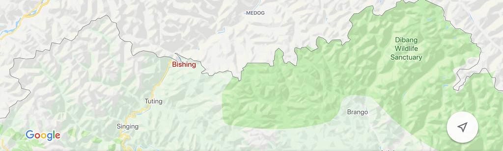


Images 1 to 4 show the general location of the areas we are speaking about: Chaglagam, where we were not able to establish any specific incursion has the red marker, and the grey marker on the top shows the Bishing salient on the Brahmaputra, west of the Dibang Wildlife Sanctuary.

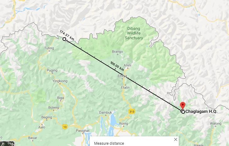
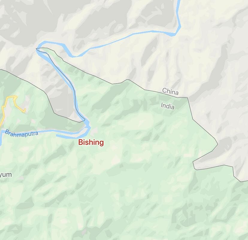
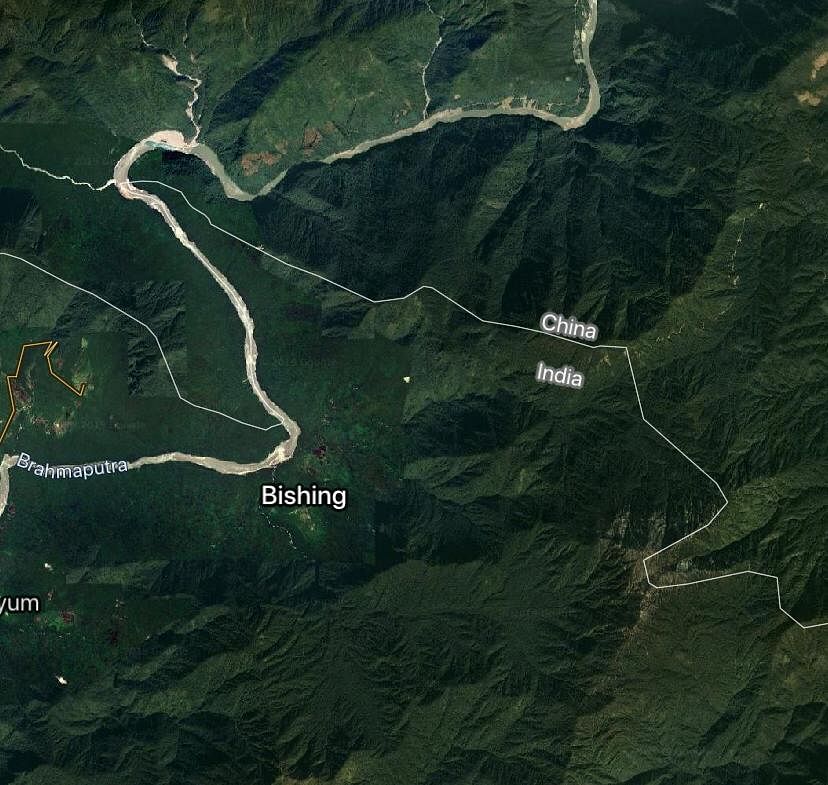
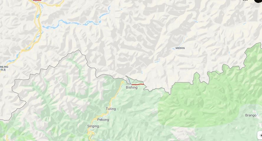
Image 5 shows the distance between the incursion point at Bishing and Chaglagam, which was also part of the MP’s claim, and the incursion point’s relative position to the Dibang Sanctuary.

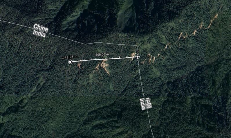

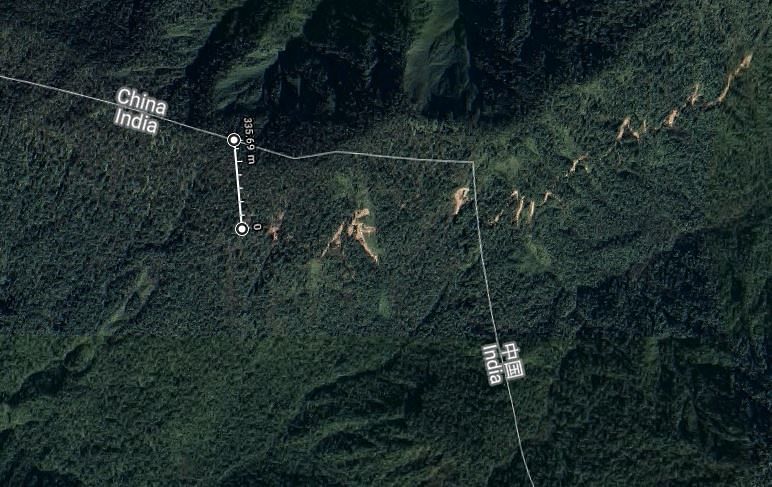
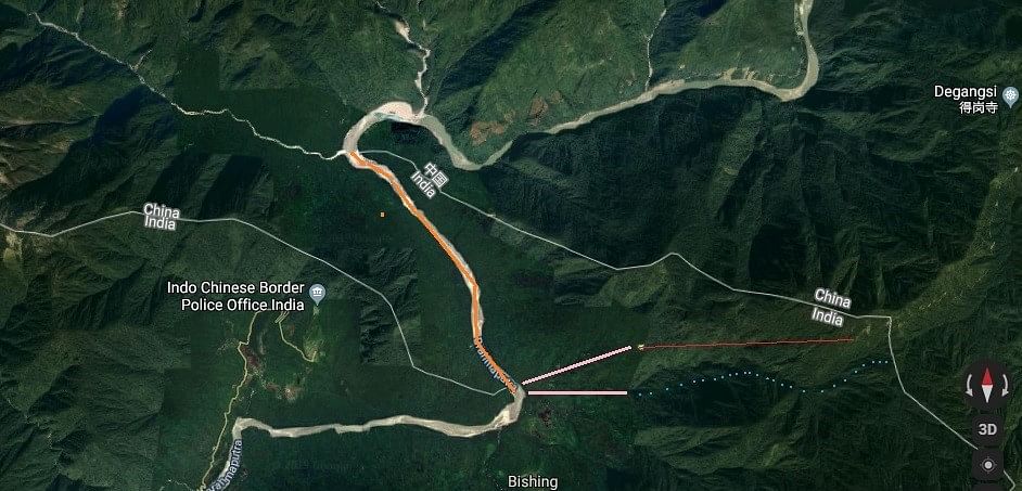
Using Google’s native measurement tool, image 6 shows the road, running from east to west, is 942 meters deep into the Indian territory and runs parallel to the border at an almost consistent depth of 300 to 400 meters (image 7).

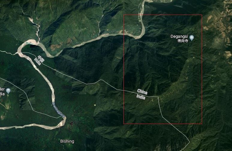
Image 8 shows the topography of the region. The thin trail is visible starting south of Degangsi, while the red marked box can be further expanded into Image 9 (below).

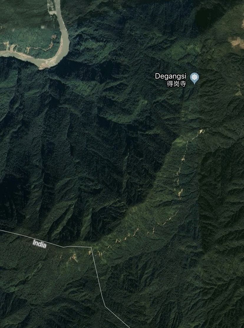
Image 9 shows the thin road entering India just where the border switches from west-east to north-south running parallel to a valley. It may be noted that trade opportunities here are non-existent given the absence of a joining road from the Indian side. This leads to a high probability that the road construction project is about creating facts on the ground.
What are “facts on the ground”? Basically when a border is disputed, the creation of population centres or infrastructure essentially forces a border to be redrawn. Assume for example that China agreed in 2015 that the LAC as is was the border, the fact that they have created infrastructure 1km west and 300 meters south into Indian territory, while India has nothing in the region, would mean that China will essentially insist the LAC be moved south of its constructed infrastructure. This is how Israel also lays claim to much of the West Bank — by creating infrastructure (and population centres) to muddy the border. The question is, what could these facts on the ground portend?

There are three possibilities as shown in image 10 above.
1: This could mean a southwards annexation from the east-west border orientation to gobble up the entire valley until it meets the plain further west (marked by the red line)
2: It could mean establishing further claim on the hill ridge just south of the road and also up to the point where it tapers down into the Brahmaputra plain (marked by a dotted blue line)
3: Maximally, it could mean a full extension up to the Brahmaputra to completely cut off this salient (two possibilities marked in light pink – The first possibility is the road itself is treated as the border and is extended up to the Brahmaputra at the point shown – that is to say an extension of the red line. The second possibility (flowing from option 2 above – China claiming the mountain ridge south of its road as the border) is that it draws the line from the end of the mountain ridge to the Brahmaputra; that is to say as an extension of the blue dotted line.
Note: In this particular salient, the border is the Brahmaputra marked in light orange.

As image 11 above shows, at worst we could be looking at a loss of an entire salient that juts into China as shown. Given the seriousness of the situation, we decided to purchase high-resolution imagery and analyse the time-series imagery to confirm the road was in fact constructed by the Chinese. The results were startling.

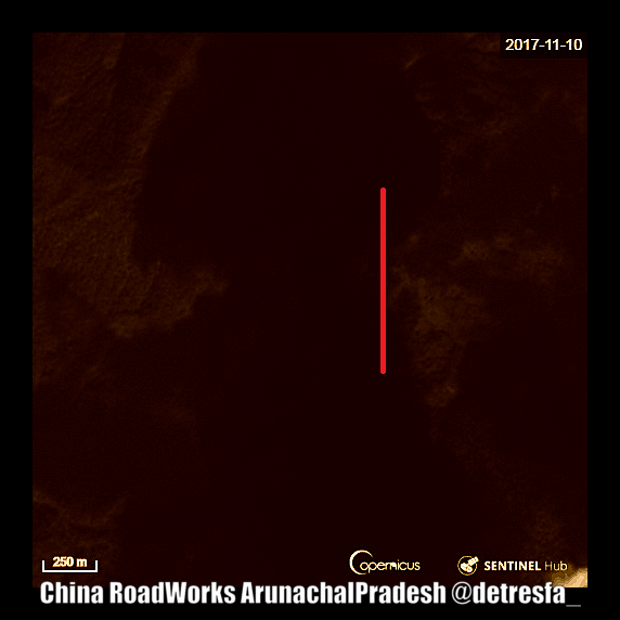
Starting in 2017, this animation (image 12) shows a clear westwards expansion originating from China (the red line marks the border). What is significant about this road is that it is backed by significant infrastructure within China from its starting point on the Brahmaputra and virtually no infrastructure of note on the Indian side.

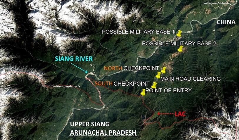
The major points of interest discernible on this road are that it has two possible military bases, two checkpoints, a clearing/gathering area and the final point of entry into India, which as of now are clearly inoperative given the depth of the intrusion (image 13). Below are the high-resolution images of each of these points of interest.

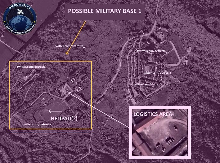
The first is a possible military base on the Brahmaputra (image 14). This shows some clearly developed infrastructure including car and truck fuel stations and construction. Noticeable is the complete lack of civilian presence, huts, etc. The reason we are convinced it is a military base is due to the sheer lack of civilian habitation around it, though it could equally be an innocent outpost, which is just not commercially viable.

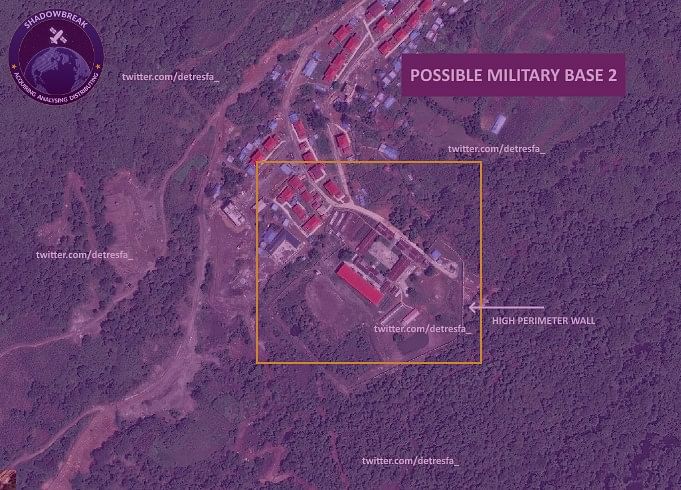
Possible military base two on the other hand (image 15) is much more pronounced: the buildings are mostly large and administrative in nature with excellent quality construction and a significant human presence. Of particular note is the extensive and high perimeter wall separating an administrative area. Given the population outside this administrative area is not high (a hundred or so at most), the size of the buildings seems to indicate a military administrative outpost, built for scaled up operations, if and when desired.

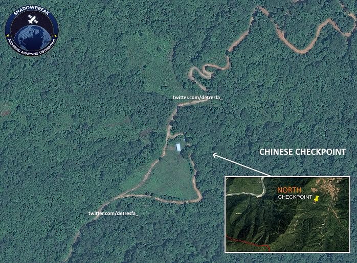
Image 16 shows what we have labelled the North Checkpoint. The opening here has clearly been made much earlier. The greening of the clearing shows that there was not much human or vehicle movement here allowing the grass to grow back. Again, there is a solitary building here with a side road leading from and joining back onto the main road, presumably to not let the oncoming traffic block the main road.

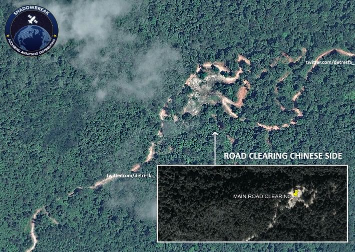
The next point of interest related to the portion of the road still in China is a large artificial clearing (image 17). We are unable to determine the exact purpose of this clearing, given that even time series did not show the presence of construction equipment or camps. However, given the precipitation and rate of flora regrowth, the barrenness of this clearing is important, though we are unable to determine the exact reason, save the prolonged presence of humans and or vehicles.

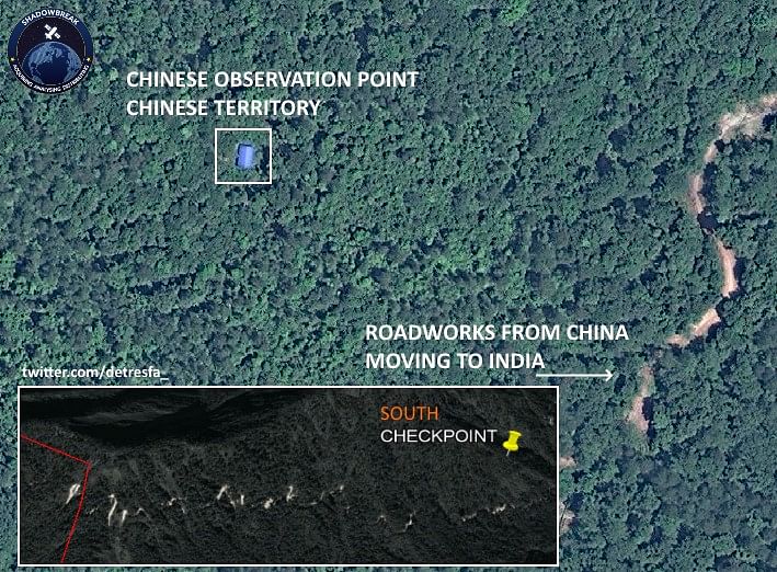
The clearing leads to the “southern checkpoint” (image 18). Given its location atop a relative elevation (as can be seen in the inset), we suspect this to be more of an observation outpost than a checkpoint. The blue roofs are a clear indication of ownership (Indian installations use green corrugated iron while the Chinese use blue).

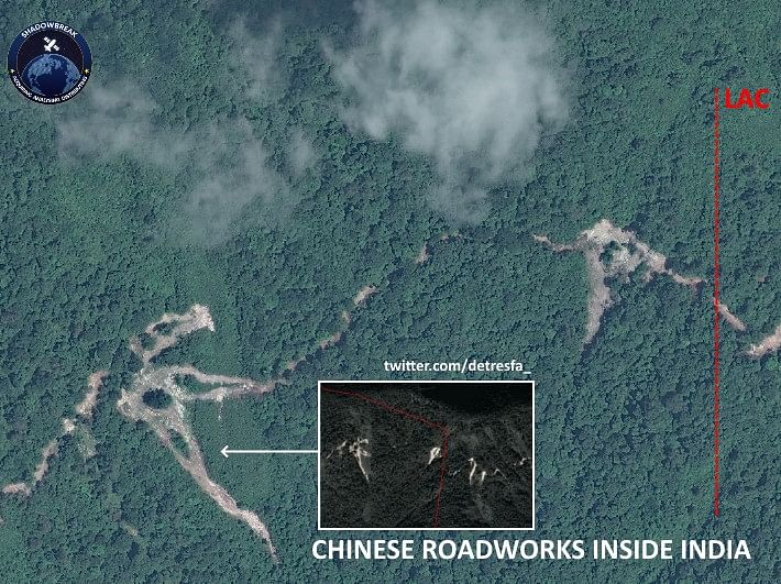
Finally, we come to the border (marked by the red dotted line). Note the complete lack of any Indian presence here in image 19: be it on the border or on the first clearing or the second clearing. As the time series animation in this article showed, these two clearings came up post 2017 clearly as an extension of the Chinese road. It is also important to note here that while the Chinese have expanded the road into Indian territory, they have not built any structure inside India. The road leading further west from the second, larger clearing on the left of the image above goes a further 200-500 metres, although we are unable to plot exactly how far.

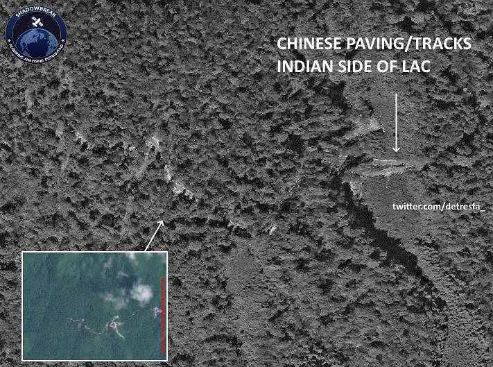
What we can say with absolute certainty is that even though we could not find bulldozers (MP Tapir Gao made a clear claim of bulldozers being used), we did find tell-tale marks (image 20) of bulldozer usage on the westernmost clearing on Indian soil. The east-west orientation of this bulldozer activity is in the same direction as the road that is proceeding further into India. At any rate, the use of some heavy earth moving equipment is obvious, and given there is no suitable access to this point from the Indian side, these bulldozers could have only come from China. This means the Chinese have used heavy earth moving equipment, possibly bulldozers, deep inside Indian territory.
The findings of Chinese intrusion deep into Indian territory, without any challenge or counter from the Indian side, is clear and unambiguous in the Bishing salient. The Chinese have entered at least 1 kilometre into Indian territory, constructed a motorable road using heavy earth moving equipment and all of this has been done systematically and persistently since 2017 at least, without any visible Indian opposition.
This clearly proves BJP MP Tapir Gao’s claim. It is therefore highly likely that his claims regarding an incursion into the Chaglagam sector could also be true. However, as of now, possible incursions in Chaglagam are neither visible to satellite nor backed up by a visible, motorable road or supporting infrastructure on the Chinese side of the border. What remains to be seen is how this situation develops and how it is countered, given the total lack of response from the Indian government to this alarming development since 2017.
Time series animation courtesy: @sentinel_hub and @CopernicusEU
High-resolution images courtesy: @sbreakintl and @detresfa_
The author is a senior fellow at the Institute of Peace and Conflict Studies. He tweets @iyervval. Views are personal.