


Quoting “government sources”, The Indian Express, on 9 April, reported on its front page: India said no to China proposal on pullback from Hot Springs. The proposal to disengage troops from Patrolling Point 15 was made “around the time” the Chinese foreign minister, Wang Yi, visited India on 24-25 March. The proposal was rejected by India as the Chinese wanted our troops to go back to back to Karam Sigh Post, which is approximately 30-35 km, albeit laterally, behind the Line of Actual Control. This would have denied Indian troops access to PP 15 and 16, while the Chinese army withdrew just behind it.
The motive for the “government’s leak” is not clear as the disagreement with respect to PP 15 was evident during the 13th, 14th and 15th Corps Commander Level meetings held on 10 October 2021, 12 January 2022 and 11 March 2022, respectively. Either the government was trying to expose the naive Chinese attempt to herald Wang Yi’s visit as a success or shaping public perception to accept the status quo. The report has not been denied by the government. However, it is also indicative of the uncompromising and tough approach of China with respect to the Chang Chenmo Sector.
We are fast approaching the two-year benchmark with regard to the Chinese intrusions and the resultant standoff in eastern Ladakh. Disengagement with buffer zones (predominantly on our side of the LAC) with no patrolling/deployment/ development of infrastructure, has taken place in the Galwan River, north and south of Pangong Tso and Gogra/Changlung Nala. China continues to occupy the intrusion areas in Depsang Plains, between PP 15 and 16 and south of Demchok in Charding-Ninglung Nala.
There has been no official briefing with maps/satellite imagery in the last two years. The public has no knowledge of the terrain and the operational situation, and the government gets away with denial and obfuscation. I explain the strategic significance of the Chang Chenmo Sector and why China is adopting an uncompromising stand.
Also Read: China’s PLA now has more say in weapon development, procurement. India stuck for 8 years
Significance of the Chang Chenmo Sector
Chang Chenmo Sector is the gateway to the southern approaches to Aksai Chin and this is where the first clash took place between India and the Peoples Liberation Army on 21 October 1959 (National Police Day), when a Central Reserve Police Force patrol of 20 personnel was ambushed at Kongka La. Ten CRPF jawans were killed and seven were taken prisoners of war. In this sector, the LAC and the 1959 Claim Line coincide, and as such, there was no area of differing perception prior to May 2020. The PLA had captured this area in 1962 but after the war, it unilaterally withdrew back to the 1959 Claim Line.

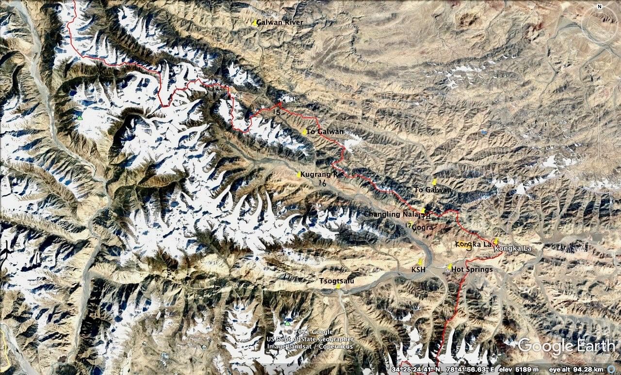
Three approaches from this sector lead to Aksai Chin. One approach runs east from Kongka La to Lanak La, through which the Tibet-Xinjiang National Highway G219 passes. Two approaches are to the north from the Kugrang River via Changlung Nala (P17 and 17A) and 30 kilometres upstream via Jianan Pass (PP16 and 15). Both these approaches lead to the upper reaches of the Galwan River in the vicinity of Samzungling. In 1962, our troops moved via Changlung Nala to set up a post that fought a heroic battle. Using these approaches, we can cut off 70-80 kilometres of the Galwan River Valley and neutralise any attempt by the PLA to cut off the Darbuk-Shyok-Daulat Beg Oldi Road via PP14.
From the Chinese side, two highways to the north-east and east lead to Aksai Chin. To the north, two roads connect it to the Galwan River Valley for interoperability. To the south, it is connected by a road to Khurnak Fort and now via a new bridge to the south of Pangong Tso permitting interoperability.
Chang Chenmo Sector is connected to Lukung at the northern tip of Pangong Tso through a 100-kilometre-long road via Marsimik La pass. This road can be cut-off at Hot Springs, Tsogtsalu and at Phobrang via Ane La pass. The 1959 Claim Line is a cartographic marvel based on exceptional terrain evaluation. Unless we take offensive action to alter its status, large chunks of our territory ahead of the main defences can be isolated and captured. Terrain configuration and quantum of troops force us to hold main defences well back on dominating heights that are approximately 80 kilometres behind the LAC in this sector.
In order to protect this vast forward zone and also develop infrastructure for offensive operations, we have been aggressively developing roads right up to the LAC since 2007. The development of roads and border infrastructure was given greater impetus by the Narendra Modi government in the last eight years. We developed a 40 kilometres-long road in the Kugrang River, from which two feeder roads were being developed from PP16 to Jianan Pass/PP 15 and from PP17 to PP17A.
We made the cardinal mistake of not deploying troops prior to the development of border infrastructure in sensitive areas. We were so cavalier that we did not even deploy the Indo-Tibetan Border Police posts to act as tripwires. Routine periodic patrolling continued as it has been in the last 60 years. Our premise was probably based on the assumption that the deployment of troops would raise China’s heckles. But heckles were raised and China perceived border development as a threat. This was the immediate casus belli for the PLA offensive manoeuvre in April and May 2020.
Also Read: Fear of China stealing US’ F-35 wreckage & tech just sensational media speculation
Operational situation in Hot Springs
In May 2020, India had ITBP posts at Karam Singh Hill, Gogra/PP17 and at Hot Springs west of Kongka La. It needs to be clarified that the landmark ‘Hot Springs’ has been loosely used by government sources as well as the media. There are a number of hot springs in the area. The original name was derived from the hot spring in the Changlung Nala on the Chinese side of the LAC. There is only one post known as Hot Springs west of Kongka La wrongly marked as ‘Gogra’ on Google Maps. Gogra is a famous pasture land in the vicinity of PP17 to the north of Karam Singh Hill.
Given the terrain configuration and our extremely thin deployment, the PLA simply walked into these areas where we did not have any troops deployed. From Jianan Pass/PP15, the PLA intruded approximately four kilometres between PP15 and 16. In Changlung Nala the intrusion was approximately three kilometres to come in eyeball contact with our post at Gogra/PP17. These two intrusions blocked the construction of feeder roads to PP15 and PP17A. The higher intrusion areas dominate the lower Kugrang River Valley and in event of hostilities would act as the firm base to capture it. The Chinese claimed the intrusion areas as actual alignment of the LAC/1959 Claim Line implying that India had come across the same over the years. There was also a minor intrusion from the east and south at Hot Springs to prevent the development of the road towards Kongka La. Disengagement in this area took place in July 2020.
In the 12th Corps Commander Level Talks on 31 July 2021, China and India agreed to disengage in the area of Gogra/PP17. The PLA has pulled back across the LAC at PP17A. The Modi government has not acknowledged it but it is my assessment that a buffer zone between PP17 and PP17A has been agreed to, which is almost entirely on our side of the LAC. In my view, the Chinese agreed to disengagement in this area as it tactically holds dominating positions and can come back at will.
Three rounds of Corps Commander Level talks — 10 October 2021, 12 January 2022, and 11 March 2022 — have been held to disengage from Jianan Pass/PP15 but the impasse has not been broken. The Chinese insist on a 30 km-long buffer zone from PP15 to PP 17, entirely on our side of the LAC, which is not acceptable to us. This was the proposal that The Indian Express referred to.
China had a clear strategic short term aim to prevent the development of border infrastructure in sensitive areas and secure the 1959 Claim Line in areas that we were controlling/patrolling before May 2020. It has managed to do so without firing a shot in all areas except the Indus Valley from Demchok to Fukche, which historically has been left alone due to settled villages.
China agreed to a compromise with respect to the north bank of Pangong Tso, due to the terrain leverage we had after securing the Kailash Range. It viewed this as a standalone agreement and is unlikely to disengage from Depsang Plains, PP 15 and Charding-Ninglung Nala unless we cede vast buffer zones in our territory. Capability differential, unfavourable terrain configuration and risk of escalation to a limited war, virtually rule out a military option. It is better to swallow the bitter pill and get the best bargain with respect to buffer zones through negotiations, until we are in a position to economically and militarily challenge China.
Lt Gen H S Panag PVSM, AVSM (R) served in the Indian Army for 40 years. He was GOC in C Northern Command and Central Command. Post retirement, he was Member of Armed Forces Tribunal. Views are personal.