

Ninong Ering’s tweet implied that a barrier dam created on Yarlung Tsanpo as a result of landslide in Tibet would cause floods in Arunachal and Assam.
New Delhi: A tweet posted by an Arunachal Pradesh MP about a possible barrier dam breach on the Yarlung Tsangpo — as the Brahmaputra river is known on the Tibetan side — has triggered flood panic in the northeast.
So much so that the Centre has rushed National Disaster Response Force (NDRF) teams to the region. But a close study of satellite images of the region indicate that the fear could be misplaced.
On Thursday, Ninong Ering, MP from the Arunachal East constituency, tweeted that there was a landslide in Tibet, which could create an artificial dam on Yarlung Tsangpo. The tweet implied that this could have devastating effects on the downstream areas in Arunachal Pradesh in the event of any breach of this barrier dam.
Wrote to @SushmaSwaraj Ji and @arjunrammeghwal Ji on the issue of blockade by Yarlung zangbo which is leading towards drying up of rivers in Arunachal. Attached are pics of letter and drying rivers along Tuting and Pasighat area.
Hope @PMOIndia takes required action immediately. pic.twitter.com/44guZAqe9S
— Ninong Ering (@ninong_erring) October 18, 2018
The MP also claimed to have written to External Affairs Minister Sushama Swaraj and Minister of State for Water Resources Arjun Ram Meghwal seeking their intervention in the matter.
How the rumour spread
The tweet by Ering caused widespread panic because just a week ago a barrier dam, formed on the Jinsha river, a tributary of the Yangtze, had forced large-scale evacuations in border regions of Tibet with Sichuan.
Following Ering’s tweet, local media outlets published reports about a possible dam breach on Yarlung Tsangpo, posting images of the Jinsha barrier dam and its slush.
What actually happened
The event that caused the entire fiasco had taken place at a location called Mainling, about 40 km from Nyingchi, a major military town opposite India’s Tuting sector.
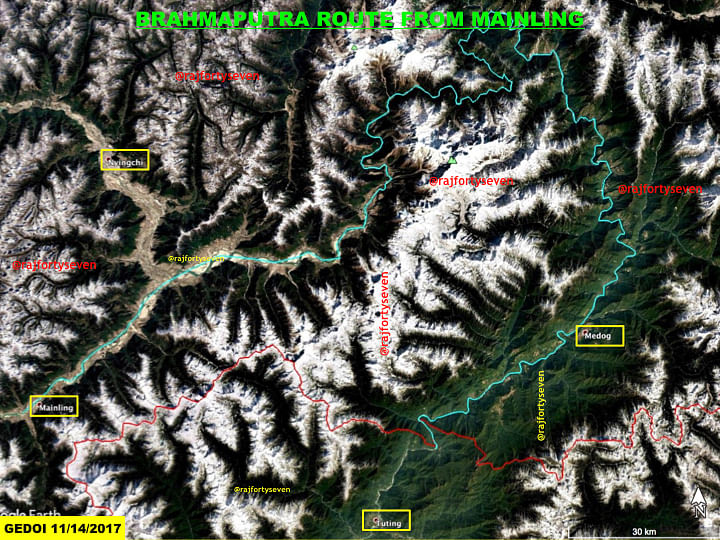
The Brahmaputra has to travel 360 km from Mainling to the Indian border and then another 240 km to reach Pasighat in Arunachal. The total distance covered is more than 600 km.
The Brahmaputra, called Siang in Arunachal Pradesh, suddenly widens from 500 m to 700 m, then to 1.8 km within a stretch of 15 km. It means that even if the sudden gush of water reaches Pasighat, the water level will recede immediately due widening of the river over the 15-km stretch.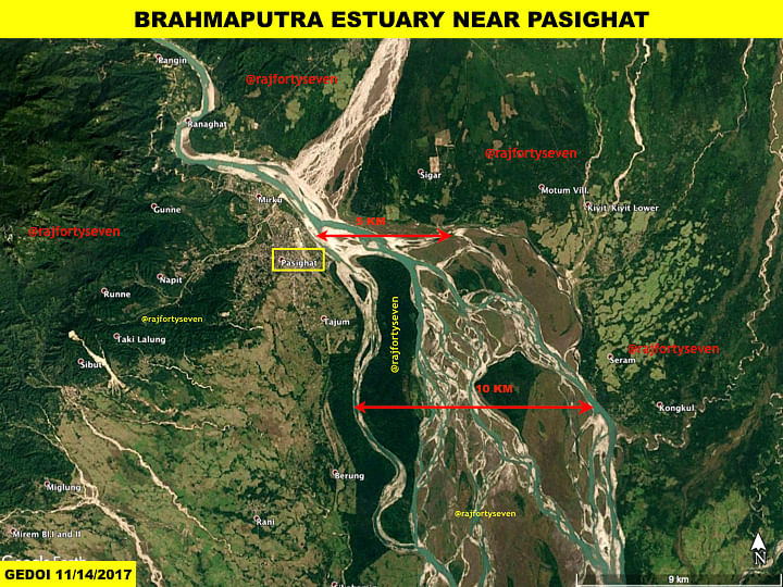
Assessment
It’s not very difficult to understand that if any barrier dam is breached before Mainling, it will spread water first in Mainling valley, then to Nyingchi before moving another 300 km through numerous gorges losing its speed.
The Pasighat Hydrological Station monitoring the Brahmaputra waters has issued a hydrograph showing a water level rise from 151 m (normal) to 152.5 m — an increase of 1.5 m, which was below even the warning level.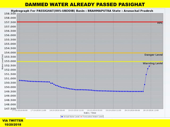
If this amount of water spreads over a 10-km stretch, there would hardly be any effect on downstream areas.
The logical move by India would be to first assess the situation and react only if any significant development is observed in Chinese towns of Nyingchi, about 300 km from India, and at Metok, near the Indian border.
What so ever be, people’s used many comments, regarding Siang river water, level, I m staying in such a place, from where I can see The river Siang water level is rising or not. People’s make unnecessary comments. Today in the morning, for hours water level increased. But now it is ok time 8:41 pm dated 20/10/2018