

The Brahmaputra is getting naturally dammed up in Tibet, leading to a dual fear — first it will dry up, then release a ‘water bomb’ when it breaches the ‘dam’.
New Delhi: The flood scare over the Brahmaputra in Arunachal Pradesh is over. As ThePrint had analysed with satellite imagery and data, the ‘crises’ around the corner were exaggerated.
Ninong Ering, the MP from Arunachal East, had tweeted about two potential ‘crises’ due to landslides across the border — first, the river would get dammed up naturally, reducing the flow of water into India, and then a ‘water bomb’ would be released once the ‘dam’ was breached.
Also read: How a tweet by an Arunachal Pradesh MP created flood scare in northeast
But neither happened. The dammed water has crossed Pasighat Hydrological Station in East Siang district safely.
Yet, it’s important to understand what caused this damming up of the Brahmaputra, and if there could be potential risk in the future.
The barrier dam
The longest and deepest canyon in the world is Brahmaputra Canyon between Mt Namcha Barwa and Mt Gyala Peri.
Gyala Peri, along with Sedong Ri and Tiba Kangri, form a gorge southwards. The gorge has four glaciers, forming a funnel before their waters join the Brahmaputra.
The mountains in this Himalayan region — being very brittle and seismically active — have faced many landslides, avalanches and combinations of both.
In the last week of December 2017, small landslides along the gorge of Sedong Ri combined with wasted glaciers debris possibly created a natural barrier dam at 29°44’53.11” N 94°56’15.88” E.
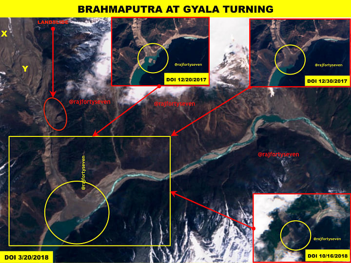
Satellite images from 30 December 2017 suggest that the barrier dam did not hold for long, so there was no alarm last year.
However, images from March, June and October 2018 very vividly show that the major portion of the barrier dam continued to hold.
The status of the barrier dam remains same as on 16 October 2018, observed from the latest satellite image of 21 October 2018.
Gyala village
Gyala or Gyala Dzong is a small village with about 30 households (10 of them across the river). It is probably the last village in Mainling county.
During the entire crisis of October 2018, the water levels did not reach the village and remained much below.
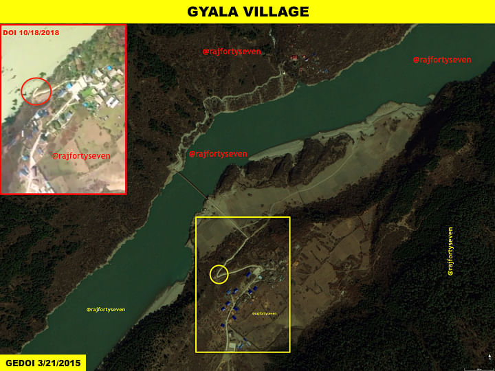
The rise in water levels measured on Google Earth is less than 30m. The canyon — of approximately 250m width — would need to form a reservoir about 65 km long for it to hold 484 million cubic metres (MCM) of water.
Also read: Modi-Xi agree on sharing water data on Brahmaputra, satellites show why it is ‘impossible’
Obviously, the figure of 300 MCM received from China on first day, and later 484 MCM, were highly exaggerated. This was later confirmed from hydrography at all downstream stations below Tuting in India.
It is unfathomable why China put out such extremely high figures, but it did create a panic in India.
Daling bridge damaged
The Daling bridge, located about 22 km upstream from the Gyala barrier dam, was damaged during this crisis.
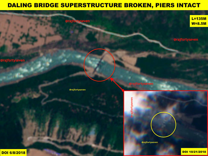
The bridge, 135 metres long and constructed in 2015, was the only structure damaged in the entire canyon. The damage caught on satellite imagery indicates a very poor engineering design, as only the superstructure is observed strewn about in span slabs.
The bridges further upstream were not damaged, indicating the length of the reservoir formed by the Gyala barrier dam to be approximately 25 kms.
Considering an average width of 150m and a height of 20m at most, the water contained in the reservoir would have been 75 MCM and not 484 MCM.
Likely to recur
A study of the satellite images shows there’s a strong likelihood that such an event will be repeated at the same location.
The four glaciers emanating southwards from the ridge line formed by Tiba Kangri, Sedong Ri and Gyala Peri are almost two kilometres wide when they converge.
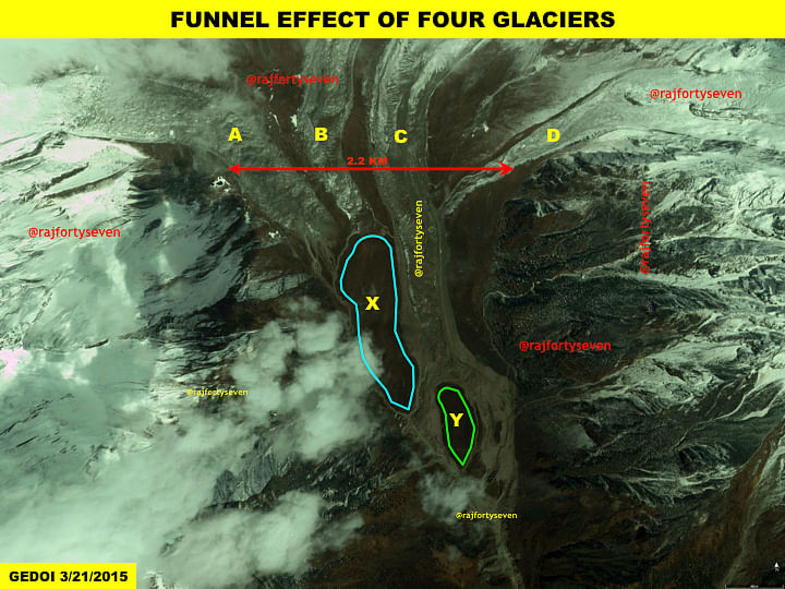
The first two glaciers A & B are blocked by landmass X, which is much higher than the two glaciers. The landmass Y blocks the C & D glaciers, although the main glacier C, known as Sedong Ri glacier, is bifurcated around the landmass.
Clearly, the glaciers are pushing the landmasses X & Y towards the river. The movement of glaciers is quite slow, but seismic activity may trigger a slide of these large landmasses, blocking the flow into the Brahmaputra.
Minor landslides along the gorge and heavy snowballing — triggering large avalanches — may trigger such an occurrence.
India needs to monitor this area and the entire Brahmaputra canyon very closely, to ensure safety of its citizens without creating panic.
*This article was updated to include new information about the broken Daling bridge.